Property Record
615 Nc Highway 66 S, Kernersville, NC 27284
NEARBY LISTINGS FOR SALE OR LEASE
Property Detail
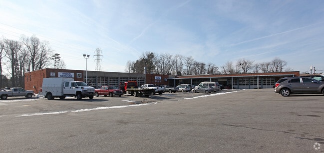
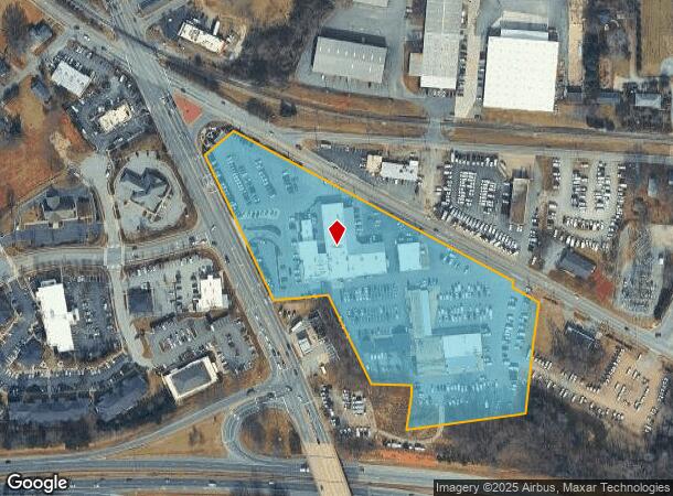
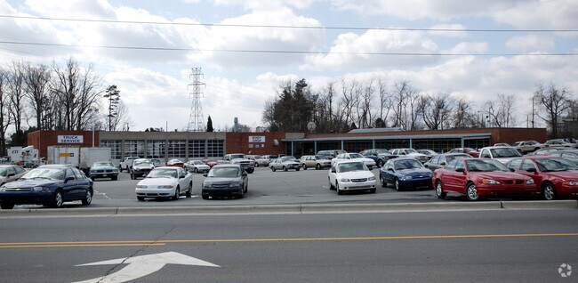
615 Nc Highway 66 S
Winston-Salem, NC
Parks Chevrolet Truck Body Sh
6886-52-8219
PARKS CHEVROLET TRUCK BODY SH LO:105A BL:2116 BU:1
Commercialnec
Forsyth
X
North Carolina
3710688600J
105a
2023
8.71 AC
2025
Kernersville
003202
Greensboro/Winston-Salem
488 SF
DEMOGRAPHICS near 615 Nc Highway 66 S
1 Mile
3 Mile
5 Mile
2024 Total Population
5,453
29,322
61,184
2029 Population
5,644
30,480
63,391
Pop Growth 2024-2029
+ 3.50%
+ 3.95%
+ 3.61%
Average Age
41
42
42
2024 Total Households
2,659
12,900
25,379
HH Growth 2024-2029
+ 3.50%
+ 3.97%
+ 3.67%
Median Household Inc
$42,463
$63,826
$76,043
Avg Household Size
2.00
2.20
2.40
2024 Avg HH Vehicles
2.00
2.00
2.00
Median Home Value
$198,691
$240,434
$240,361
Median Year Built
1980
1988
1991
Nearby Places
Map Layers
Map Styles
 Street
 Aerial
- Restaurants
- Banks
- Shops
- Fitness
- Groceries
PUBLIC TRANSPORTATION
AIRPORT
Piedmont Triad International
DRIVE
WALK
Distance
Piedmont Triad International
20 min
12.9 mi
Nearby Properties
Address
Land Use
TOTAL SIZE
Lot Size
Zoning
Address
Land Use
TOTAL SIZE
Lot Size
Zoning
179,681 SF
38.53 AC
MBP
Address
Land Use
TOTAL SIZE
Lot Size
Zoning
274,486 SF
30.31 AC
MBP
Address
Land Use
TOTAL SIZE
Lot Size
Zoning
1,001,670 SF
94.34 AC
BI
Address
Land Use
TOTAL SIZE
Lot Size
Zoning
667,440 SF
53.44 AC
BI
Address
Land Use
TOTAL SIZE
Lot Size
Zoning
122,848 SF
22.70 AC
RM18-S
Address
Land Use
TOTAL SIZE
Lot Size
Zoning
777,963 SF
133.64 AC
BI
Address
Land Use
TOTAL SIZE
Lot Size
Zoning
576,252 SF
59.82 AC
GI,LI
Address
Land Use
TOTAL SIZE
Lot Size
Zoning
79,154 SF
9.36 AC
TND-S
Address
Land Use
TOTAL SIZE
Lot Size
Zoning
93,691 SF
15.40 AC
MU-S
Address
Land Use
TOTAL SIZE
Lot Size
Zoning
254,290 SF
21.12 AC
RM-12
Address
Land Use
TOTAL SIZE
Lot Size
Zoning
350,268 SF
30.53 AC
BI
Address
Land Use
TOTAL SIZE
Lot Size
Zoning
70,113 SF
19.06 AC
RM18-S
Address
Land Use
TOTAL SIZE
Lot Size
Zoning
115,838 SF
14.41 AC
GI-C
Address
Land Use
TOTAL SIZE
Lot Size
Zoning
129,895 SF
30.33 AC
RM18
Address
Land Use
TOTAL SIZE
Lot Size
Zoning
202,539 SF
23.70 AC
HB-S
Address
Land Use
TOTAL SIZE
Lot Size
Zoning
275,040 SF
28 AC
BI
Address
Land Use
TOTAL SIZE
Lot Size
Zoning
87,741 SF
15.44 AC
RM18
Address
Land Use
TOTAL SIZE
Lot Size
Zoning
545,857 SF
51.60 AC
GI
Address
Land Use
TOTAL SIZE
Lot Size
Zoning
39,959 SF
11.29 AC
GB-S
Address
Land Use
TOTAL SIZE
Lot Size
Zoning
451.32 AC
MU-C
Address
Land Use
TOTAL SIZE
Lot Size
Zoning
258,154 SF
39.55 AC
GI
Address
Land Use
TOTAL SIZE
Lot Size
Zoning
244,562 SF
29.92 AC
BI
Address
Land Use
TOTAL SIZE
Lot Size
Zoning
277,250 SF
30.15 AC
GI
Address
Land Use
TOTAL SIZE
Lot Size
Zoning
136,068 SF
19.46 AC
HB-S
Address
Land Use
TOTAL SIZE
Lot Size
Zoning
121,981 SF
14.48 AC
HB-S
Address
Land Use
TOTAL SIZE
Lot Size
Zoning
109,169 SF
40.18 AC
RS30
Address
Land Use
TOTAL SIZE
Lot Size
Zoning
83,774 SF
7.51 AC
GB-S
Address
Land Use
TOTAL SIZE
Lot Size
Zoning
74,608 SF
8.68 AC
MBP
Address
Land Use
TOTAL SIZE
Lot Size
Zoning
160,179 SF
23.75 AC
LI-C,RS20
Address
Land Use
TOTAL SIZE
Lot Size
Zoning
603,494 SF
48.87 AC
LI
The World's #1 Commercial Real Estate Marketplace
Connect with us
© 2025 CoStar Group
The information above has been obtained from sources believed reliable. While we do not doubt its accuracy we have not verified it and make no guarantee, warranty or representation about it. It is your responsibility to independently confirm its accuracy and completeness. Any projections, opinions, assumptions, or estimates used are for example only and do not represent the current or future performance of the property. The value of this transaction to you depends on tax and other factors which should be evaluated by your tax, financial, and legal advisors. You and your advisors should conduct a careful, independent investigation of the property to determine to your satisfaction the suitability of the property for your needs.