Property Record
615 Odlin Rd, Bangor, ME 04401
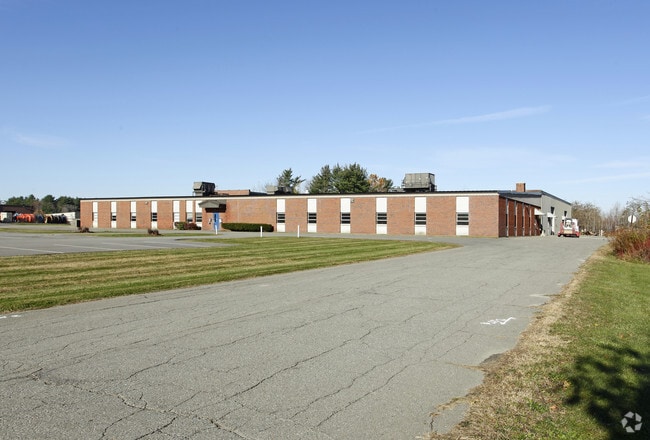

Property Detail
615 Odlin Rd
BANG-000018R-000000-000002
Penobscot
Officebuilding
Maine
I&S
2
B and X Area of moderate flood hazard, usually the area between the limits of the 100-year and 500-year floods.
17 AC
2025
Maine North & Bangor
2025
Other Market Areas
000700
Bangor, ME
39,972 SF
NEARBY LISTINGS FOR SALE OR LEASE
-
-
View all Bangor listings for lease on LoopNet.com
DEMOGRAPHICS near 615 Odlin Rd
1 mile
3 mile
5 mile
2025 Total Population
20
23,302
51,535
2030 Population
23
23,994
52,493
Pop Growth 2025-2030
+ 15.00%
+ 2.97%
+ 1.86%
Average Age
45
43
43
2025 Total Households
9
10,837
22,817
HH Growth 2025-2030
+ 11.11%
+ 3.10%
+ 1.87%
Median Household Inc
$59,999
$59,885
$65,744
Avg Household Size
1.90
2.00
2.10
2025 Avg HH Vehicles
2.00
1.00
2.00
Median Home Value
$250,000
$245,934
$257,326
Median Year Built
2011
1959
1968
Nearby Places
Map Layers
Map Styles
 Street
 Aerial
Layers
 Traffic
 Biking
Places
Listings with unknown addresses are not visible on the map
- Restaurants
- Banks
- Shops
- Fitness
- Groceries
PUBLIC TRANSPORTATION
AIRPORT
Bangor International
Drive
Walk
Distance
Bangor International
8 min
3.0 mi
Freight Ports
Searsport, ME
Drive
Walk
Distance
Searsport, ME
50 min
32.0 mi
SALE & LEASE HISTORY
LISTING DATE
SALE/LEASE

Sep 25, 2016
For Lease
Jul 05, 2022
For Lease
Nearby Properties
Address
Land Use
TOTAL SIZE
Lot Size
Zoning
Address
Land Use
TOTAL SIZE
Lot Size
Zoning
466.65 AC
ADD
Address
Land Use
TOTAL SIZE
Lot Size
Zoning
609,180 SF
6.68 AC
USD
Address
Land Use
TOTAL SIZE
Lot Size
Zoning
Address
Land Use
TOTAL SIZE
Lot Size
Zoning
243,694 SF
2.95 AC
G&ISD
Address
Land Use
TOTAL SIZE
Lot Size
Zoning
6.37 AC
UID
Address
Land Use
TOTAL SIZE
Lot Size
Zoning
87,750 SF
ADD
Address
Land Use
TOTAL SIZE
Lot Size
Zoning
400 SF
3.44 AC
WDD
Address
Land Use
TOTAL SIZE
Lot Size
Zoning
100,800 SF
1.34 AC
DDD
Address
Land Use
TOTAL SIZE
Lot Size
Zoning
12,950 SF
23.39 AC
31 - I
Address
Land Use
TOTAL SIZE
Lot Size
Zoning
168,615 SF
19.44 AC
MDR-1
Address
Land Use
TOTAL SIZE
Lot Size
Zoning
115,044 SF
13.30 AC
G&ISD
Address
Land Use
TOTAL SIZE
Lot Size
Zoning
38 AC
G&ISD
Address
Land Use
TOTAL SIZE
Lot Size
Zoning
Address
Land Use
TOTAL SIZE
Lot Size
Zoning
110,031 SF
3.81 AC
GC&S
Address
Land Use
TOTAL SIZE
Lot Size
Zoning
184,000 SF
16.43 AC
31 - I
Address
Land Use
TOTAL SIZE
Lot Size
Zoning
119,930 SF
11.51 AC
S&PS
Address
Land Use
TOTAL SIZE
Lot Size
Zoning
7 AC
WDD
Address
Land Use
TOTAL SIZE
Lot Size
Zoning
144,000 SF
111.04 AC
32 - I
Address
Land Use
TOTAL SIZE
Lot Size
Zoning
109,507 SF
1.96 AC
G&ISD
Address
Land Use
TOTAL SIZE
Lot Size
Zoning
32,570 SF
1.38 AC
G&ISD
Address
Land Use
TOTAL SIZE
Lot Size
Zoning
246,766 SF
22.44 AC
S&PS
Address
Land Use
TOTAL SIZE
Lot Size
Zoning
13.58 AC
INDUST
Address
Land Use
TOTAL SIZE
Lot Size
Zoning
39.32 AC
CB
Address
Land Use
TOTAL SIZE
Lot Size
Zoning
69,703 SF
7.92 AC
USD
Address
Land Use
TOTAL SIZE
Lot Size
Zoning
66,333 SF
5.31 AC
GC&S
Address
Land Use
TOTAL SIZE
Lot Size
Zoning
2.50 AC
IND
Address
Land Use
TOTAL SIZE
Lot Size
Zoning
76,143 SF
1.20 AC
ADD
Address
Land Use
TOTAL SIZE
Lot Size
Zoning
56,910 SF
15 AC
G&ISD
Address
Land Use
TOTAL SIZE
Lot Size
Zoning
55,514 SF
1.86 AC
G&ISD
Address
Land Use
TOTAL SIZE
Lot Size
Zoning
33,608 SF
18.10 AC
G&ISD
The World's #1 Commercial Real Estate Marketplace
Connect with us
© 2026 CoStar Group
The information above has been obtained from sources believed reliable. While we do not doubt its accuracy we have not verified it and make no guarantee, warranty or representation about it. It is your responsibility to independently confirm its accuracy and completeness. Any projections, opinions, assumptions, or estimates used are for example only and do not represent the current or future performance of the property. The value of this transaction to you depends on tax and other factors which should be evaluated by your tax, financial, and legal advisors. You and your advisors should conduct a careful, independent investigation of the property to determine to your satisfaction the suitability of the property for your needs.