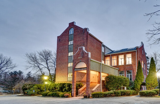
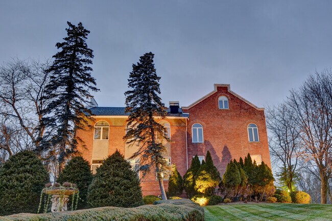
Property Record
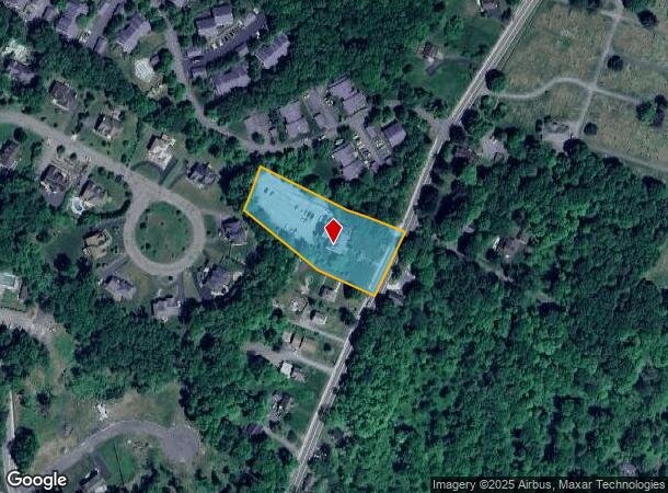
615 State Route 32, Highland Mills, NY 10930

Current Lease Availabilities
NEARBY LISTINGS FOR SALE OR LEASE
Property Detail
615 State Route 32
New York-Jersey City-White Plains, NY-NJ
Wpc Associates
335809-241-000-0001-020.000-0000
WS ST HWY 32
Commercialnec
Orange
X
New York
36071C0501E
20.00
2024
1.60 AC
2024
Newburgh
013500
Northern New Jersey
DEMOGRAPHICS near 615 State Route 32
1 Mile
3 Mile
5 Mile
2024 Total Population
5,773
51,151
75,861
2029 Population
5,883
52,695
77,935
Pop Growth 2024-2029
+ 1.91%
+ 3.02%
+ 2.73%
Average Age
38
26
30
2024 Total Households
1,866
11,402
19,280
HH Growth 2024-2029
+ 1.77%
+ 3.26%
+ 2.83%
Median Household Inc
$129,112
$66,134
$84,625
Avg Household Size
3.00
4.30
3.80
2024 Avg HH Vehicles
2.00
1.00
2.00
Median Home Value
$337,219
$434,478
$390,073
Median Year Built
1985
1996
1987
Nearby Places
- Restaurants
- Banks
- Shops
- Fitness
- Groceries
PUBLIC TRANSPORTATION
COMMUTER RAIL
Harriman (Bergen County/Port Jervis Line - NJ Transit Commuter Rail (NJ Transit), Main/Port Jervis Line - NJ Transit Commuter Rail (NJ Transit))
DRIVE
WALK
Distance
Harriman (Bergen County/Port Jervis Line - NJ Transit Commuter Rail (NJ Transit), Main/Port Jervis Line - NJ Transit Commuter Rail (NJ Transit))
12 min
5.1 mi
Salisbury Mills Cornwall (Bergen County/Port Jervis Line - NJ Transit Commuter Rail (NJ Transit), Main/Port Jervis Line - NJ Transit Commuter Rail (NJ Transit))
DRIVE
WALK
Distance
Salisbury Mills Cornwall (Bergen County/Port Jervis Line - NJ Transit Commuter Rail (NJ Transit), Main/Port Jervis Line - NJ Transit Commuter Rail (NJ Transit))
18 min
8.8 mi
AIRPORT
New York Stewart International
DRIVE
WALK
Distance
New York Stewart International
23 min
13.7 mi
Westchester County
DRIVE
WALK
Distance
Westchester County
66 min
47.5 mi
Freight Ports
Maher Terminal
DRIVE
WALK
Distance
Maher Terminal
80 min
55.4 mi
Nearby Properties
Address
Land Use
TOTAL SIZE
Lot Size
Zoning
Address
Land Use
TOTAL SIZE
Lot Size
Zoning
143.60 AC
LIO
Address
Land Use
TOTAL SIZE
Lot Size
Zoning
114.40 AC
Address
Land Use
TOTAL SIZE
Lot Size
Zoning
235,455 SF
51.70 AC
IB
Address
Land Use
TOTAL SIZE
Lot Size
Zoning
Address
Land Use
TOTAL SIZE
Lot Size
Zoning
7.30 AC
LIO
Address
Land Use
TOTAL SIZE
Lot Size
Zoning
31,507 SF
10.50 AC
UR-M
Address
Land Use
TOTAL SIZE
Lot Size
Zoning
7.50 AC
RQTRA
Address
Land Use
TOTAL SIZE
Lot Size
Zoning
23,534 SF
6.60 AC
PD
Address
Land Use
TOTAL SIZE
Lot Size
Zoning
39,235 SF
6.40 AC
Address
Land Use
TOTAL SIZE
Lot Size
Zoning
Address
Land Use
TOTAL SIZE
Lot Size
Zoning
1,476 SF
946.79 AC
R3A
Address
Land Use
TOTAL SIZE
Lot Size
Zoning
88,240 SF
3.02 AC
R-1
Address
Land Use
TOTAL SIZE
Lot Size
Zoning
113,910 SF
15 AC
PD
Address
Land Use
TOTAL SIZE
Lot Size
Zoning
159,857 SF
24.59 AC
LI
Address
Land Use
TOTAL SIZE
Lot Size
Zoning
Address
Land Use
TOTAL SIZE
Lot Size
Zoning
103,908 SF
7.40 AC
I
Address
Land Use
TOTAL SIZE
Lot Size
Zoning
92,868 SF
1.22 AC
PD
Address
Land Use
TOTAL SIZE
Lot Size
Zoning
88,855 SF
5 AC
PD
Address
Land Use
TOTAL SIZE
Lot Size
Zoning
7.60 AC
Address
Land Use
TOTAL SIZE
Lot Size
Zoning
5.20 AC
IB
Address
Land Use
TOTAL SIZE
Lot Size
Zoning
126,112 SF
3.30 AC
R-1
Address
Land Use
TOTAL SIZE
Lot Size
Zoning
15,686 SF
4.60 AC
IB
Address
Land Use
TOTAL SIZE
Lot Size
Zoning
16.80 AC
Address
Land Use
TOTAL SIZE
Lot Size
Zoning
117,855 SF
3.20 AC
PD
Address
Land Use
TOTAL SIZE
Lot Size
Zoning
110,219 SF
10.88 AC
LI
Address
Land Use
TOTAL SIZE
Lot Size
Zoning
12.10 AC
IB
Address
Land Use
TOTAL SIZE
Lot Size
Zoning
114,667 SF
22.50 AC
PD
Address
Land Use
TOTAL SIZE
Lot Size
Zoning
9.60 AC
Address
Land Use
TOTAL SIZE
Lot Size
Zoning
105,554 SF
2.90 AC
R-1
Address
Land Use
TOTAL SIZE
Lot Size
Zoning
14.40 AC
The World's #1 Commercial Real Estate Marketplace
Connect with us
© 2025 CoStar Group
The information above has been obtained from sources believed reliable. While we do not doubt its accuracy we have not verified it and make no guarantee, warranty or representation about it. It is your responsibility to independently confirm its accuracy and completeness. Any projections, opinions, assumptions, or estimates used are for example only and do not represent the current or future performance of the property. The value of this transaction to you depends on tax and other factors which should be evaluated by your tax, financial, and legal advisors. You and your advisors should conduct a careful, independent investigation of the property to determine to your satisfaction the suitability of the property for your needs.