Property Record
615 State Rt 23, Pompton Plains, NJ 07444
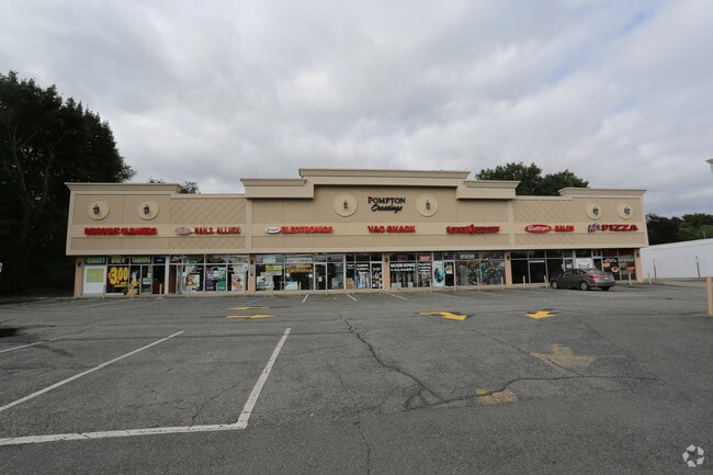

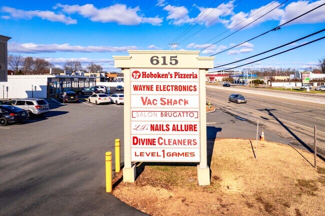
Property Detail
615 State Rt 23
Newark, NJ
ADDITIONAL LOTS: IRR
31-01404-0000-00010
Morris
Commercialnec
New Jersey
C-2
10
AE The base floodplain where base flood elevations are provided. AE Zones are now used on new format FIRMs instead of A1-A30 Zones.
1.13 AC
2024
Eastern Morris
2025
Northern New Jersey
040200
NEARBY LISTINGS FOR SALE OR LEASE
DEMOGRAPHICS near 615 State Rt 23
1 mile
3 mile
5 mile
2025 Total Population
7,908
64,991
145,931
2030 Population
8,150
67,179
150,809
Pop Growth 2025-2030
+ 3.06%
+ 3.37%
+ 3.34%
Average Age
42
44
44
2025 Total Households
2,619
23,941
53,885
HH Growth 2025-2030
+ 3.05%
+ 3.15%
+ 3.18%
Median Household Inc
$154,977
$134,041
$129,167
Avg Household Size
2.90
2.60
2.60
2025 Avg HH Vehicles
2.00
2.00
2.00
Median Home Value
$590,133
$576,560
$574,116
Median Year Built
1955
1966
1967
Nearby Places
Map Layers
Map Styles
 Street
 Aerial
Layers
 Traffic
 Biking
Places
Listings with unknown addresses are not visible on the map
- Restaurants
- Banks
- Shops
- Fitness
- Groceries
PUBLIC TRANSPORTATION
COMMUTER RAIL
Lincoln Park (Montclair-Boonton Line - NJ Transit Commuter Rail (NJ Transit))
Drive
Walk
Distance
Lincoln Park (Montclair-Boonton Line - NJ Transit Commuter Rail (NJ Transit))
9 min
4.4 mi
Mountain View (Montclair-Boonton Line - NJ Transit Commuter Rail (NJ Transit))
Drive
Walk
Distance
Mountain View (Montclair-Boonton Line - NJ Transit Commuter Rail (NJ Transit))
7 min
4.8 mi
AIRPORT
Newark Liberty International
Drive
Walk
Distance
Newark Liberty International
32 min
27.0 mi
LaGuardia
Drive
Walk
Distance
LaGuardia
48 min
35.0 mi
Westchester County
Drive
Walk
Distance
Westchester County
63 min
47.9 mi
Freight Ports
Maher Terminal
Drive
Walk
Distance
Maher Terminal
39 min
26.8 mi
SALE & LEASE HISTORY
LISTING DATE
SALE/LEASE

Oct 10, 2025
For Lease
Oct 04, 2018
For Lease
Jan 29, 2025
For Sale
Nearby Properties
Address
Land Use
TOTAL SIZE
Lot Size
Zoning
Address
Land Use
TOTAL SIZE
Lot Size
Zoning
143.16 AC
PUD
Address
Land Use
TOTAL SIZE
Lot Size
Zoning
21.99 AC
H
Address
Land Use
TOTAL SIZE
Lot Size
Zoning
10.88 AC
Address
Land Use
TOTAL SIZE
Lot Size
Zoning
18.76 AC
C-3
Address
Land Use
TOTAL SIZE
Lot Size
Zoning
264,080 SF
44.44 AC
HB
Address
Land Use
TOTAL SIZE
Lot Size
Zoning
32.21 AC
R-15
Address
Land Use
TOTAL SIZE
Lot Size
Zoning
5,880 SF
17.46 AC
I
Address
Land Use
TOTAL SIZE
Lot Size
Zoning
334,755 SF
107.89 AC
Address
Land Use
TOTAL SIZE
Lot Size
Zoning
41.71 AC
C-4
Address
Land Use
TOTAL SIZE
Lot Size
Zoning
25,064 SF
14.53 AC
HB
Address
Land Use
TOTAL SIZE
Lot Size
Zoning
131,306 SF
14.40 AC
HB
Address
Land Use
TOTAL SIZE
Lot Size
Zoning
259,919 SF
48.14 AC
Address
Land Use
TOTAL SIZE
Lot Size
Zoning
9.08 AC
H-C
Address
Land Use
TOTAL SIZE
Lot Size
Zoning
7.58 AC
R-4
Address
Land Use
TOTAL SIZE
Lot Size
Zoning
9.28 AC
R-11
Address
Land Use
TOTAL SIZE
Lot Size
Zoning
10.07 AC
R-15
Address
Land Use
TOTAL SIZE
Lot Size
Zoning
109,848 SF
14.01 AC
HB
Address
Land Use
TOTAL SIZE
Lot Size
Zoning
12.24 AC
H-C
Address
Land Use
TOTAL SIZE
Lot Size
Zoning
8.87 AC
RA1
Address
Land Use
TOTAL SIZE
Lot Size
Zoning
6.30 AC
I-2
Address
Land Use
TOTAL SIZE
Lot Size
Zoning
13.72 AC
RO
Address
Land Use
TOTAL SIZE
Lot Size
Zoning
82,061 SF
12.39 AC
R-15
Address
Land Use
TOTAL SIZE
Lot Size
Zoning
634 SF
14.76 AC
H
Address
Land Use
TOTAL SIZE
Lot Size
Zoning
6.95 AC
I-2
Address
Land Use
TOTAL SIZE
Lot Size
Zoning
357,779 SF
16.98 AC
Address
Land Use
TOTAL SIZE
Lot Size
Zoning
34.77 AC
R-15
Address
Land Use
TOTAL SIZE
Lot Size
Zoning
5.89 AC
R-9
Address
Land Use
TOTAL SIZE
Lot Size
Zoning
434 SF
53.04 AC
I-3
Address
Land Use
TOTAL SIZE
Lot Size
Zoning
145,639 SF
27.40 AC
Address
Land Use
TOTAL SIZE
Lot Size
Zoning
103,650 SF
4.81 AC
I-1
The World's #1 Commercial Real Estate Marketplace
Connect with us
© 2026 CoStar Group
The information above has been obtained from sources believed reliable. While we do not doubt its accuracy we have not verified it and make no guarantee, warranty or representation about it. It is your responsibility to independently confirm its accuracy and completeness. Any projections, opinions, assumptions, or estimates used are for example only and do not represent the current or future performance of the property. The value of this transaction to you depends on tax and other factors which should be evaluated by your tax, financial, and legal advisors. You and your advisors should conduct a careful, independent investigation of the property to determine to your satisfaction the suitability of the property for your needs.