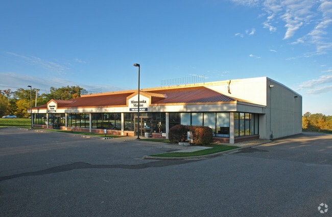
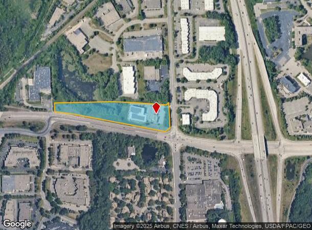
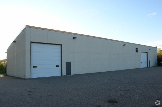
Property Record
6150 Baker Rd, Minnetonka, MN 55345
NEARBY LISTINGS FOR SALE OR LEASE
Property Detail
6150 Baker Rd
34-117-22-43-0015
Unplatted 34 117 22
Industrialgeneral
UNPLATTED 34 117 22 THAT PART OF THE SW 1/4 OF SE 1/4 LYING SLY OF THE SLY LINE OF THE PLAT OF CULLIGAN INDUSTRIAL PARK AND ITS ELY EXT THOF AND LYING NLY OF THE NLY T
X
Hennepin
27053C0339F
Minnesota
2024
5.80 AC
2024
I-494 Corridor
026208
Minneapolis/St Paul
15,504 SF
Minneapolis-St. Paul-Bloomington, MN-WI
DEMOGRAPHICS near 6150 Baker Rd
1 Mile
3 Mile
5 Mile
2024 Total Population
3,286
57,052
168,399
2029 Population
3,224
56,218
166,431
Pop Growth 2024-2029
(1.89%)
(1.46%)
(1.17%)
Average Age
43
42
42
2024 Total Households
1,445
24,963
69,920
HH Growth 2024-2029
(2.08%)
(1.52%)
(1.28%)
Median Household Inc
$95,188
$94,926
$106,411
Avg Household Size
2.10
2.20
2.30
2024 Avg HH Vehicles
2.00
2.00
2.00
Median Home Value
$396,621
$381,839
$432,315
Median Year Built
1985
1980
1980
Nearby Places
Map Layers
Map Styles
 Street
 Aerial
- Restaurants
- Banks
- Shops
- Fitness
- Groceries
PUBLIC TRANSPORTATION
AIRPORT
Minneapolis-St Paul International/Wold-Chamberlain
DRIVE
WALK
Distance
Minneapolis-St Paul International/Wold-Chamberlain
21 min
14.1 mi
Freight Ports
Port Milwaukee
DRIVE
WALK
Distance
Port Milwaukee
389 min
349.3 mi
SALE & LEASE HISTORY
LISTING DATE
SALE/LEASE

Sep 25, 2016
For Lease
Sep 25, 2016
For Lease
Sep 24, 2016
For Sale
Sep 23, 2016
For Sale
Nearby Properties
Address
Land Use
TOTAL SIZE
Lot Size
Zoning
Address
Land Use
TOTAL SIZE
Lot Size
Zoning
49,799 SF
4.96 AC
Address
Land Use
TOTAL SIZE
Lot Size
Zoning
7.68 AC
Address
Land Use
TOTAL SIZE
Lot Size
Zoning
4.89 AC
Address
Land Use
TOTAL SIZE
Lot Size
Zoning
6.83 AC
Address
Land Use
TOTAL SIZE
Lot Size
Zoning
Address
Land Use
TOTAL SIZE
Lot Size
Zoning
49,757 SF
2.88 AC
Address
Land Use
TOTAL SIZE
Lot Size
Zoning
0.90 AC
Address
Land Use
TOTAL SIZE
Lot Size
Zoning
3.07 AC
Address
Land Use
TOTAL SIZE
Lot Size
Zoning
4.84 AC
Address
Land Use
TOTAL SIZE
Lot Size
Zoning
138,997 SF
14.03 AC
OFC
Address
Land Use
TOTAL SIZE
Lot Size
Zoning
136,782 SF
6.17 AC
Address
Land Use
TOTAL SIZE
Lot Size
Zoning
4.55 AC
Address
Land Use
TOTAL SIZE
Lot Size
Zoning
3.15 AC
Address
Land Use
TOTAL SIZE
Lot Size
Zoning
233,320 SF
17.37 AC
PUD
Address
Land Use
TOTAL SIZE
Lot Size
Zoning
93,982 SF
9.33 AC
OFC
Address
Land Use
TOTAL SIZE
Lot Size
Zoning
226,252 SF
5.40 AC
Address
Land Use
TOTAL SIZE
Lot Size
Zoning
38.20 AC
Address
Land Use
TOTAL SIZE
Lot Size
Zoning
175,506 SF
14.32 AC
Address
Land Use
TOTAL SIZE
Lot Size
Zoning
10.01 AC
RM25
Address
Land Use
TOTAL SIZE
Lot Size
Zoning
314,234 SF
2.31 AC
RM25
Address
Land Use
TOTAL SIZE
Lot Size
Zoning
327,536 SF
4.76 AC
CCOM
Address
Land Use
TOTAL SIZE
Lot Size
Zoning
181,201 SF
8.30 AC
OFC
Address
Land Use
TOTAL SIZE
Lot Size
Zoning
73,905 SF
11.66 AC
B3
Address
Land Use
TOTAL SIZE
Lot Size
Zoning
41,398 SF
6.78 AC
PUD
Address
Land Use
TOTAL SIZE
Lot Size
Zoning
32,373 SF
3.82 AC
PUD
Address
Land Use
TOTAL SIZE
Lot Size
Zoning
122,801 SF
8.41 AC
RM25
Address
Land Use
TOTAL SIZE
Lot Size
Zoning
13.43 AC
Address
Land Use
TOTAL SIZE
Lot Size
Zoning
7.30 AC
RM25
Address
Land Use
TOTAL SIZE
Lot Size
Zoning
5.77 AC
RM25
Address
Land Use
TOTAL SIZE
Lot Size
Zoning
325,341 SF
35.31 AC
C-REG
The World's #1 Commercial Real Estate Marketplace
Connect with us
© 2025 CoStar Group
The information above has been obtained from sources believed reliable. While we do not doubt its accuracy we have not verified it and make no guarantee, warranty or representation about it. It is your responsibility to independently confirm its accuracy and completeness. Any projections, opinions, assumptions, or estimates used are for example only and do not represent the current or future performance of the property. The value of this transaction to you depends on tax and other factors which should be evaluated by your tax, financial, and legal advisors. You and your advisors should conduct a careful, independent investigation of the property to determine to your satisfaction the suitability of the property for your needs.