Property Record
6150 Library Rd, Bethel Park, PA 15102
NEARBY LISTINGS FOR SALE OR LEASE
-
-
View all Bethel Park listings for sale on LoopNet.com
Property Detail
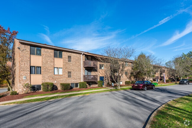
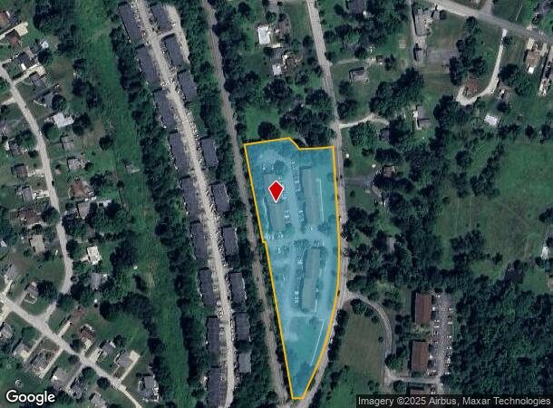
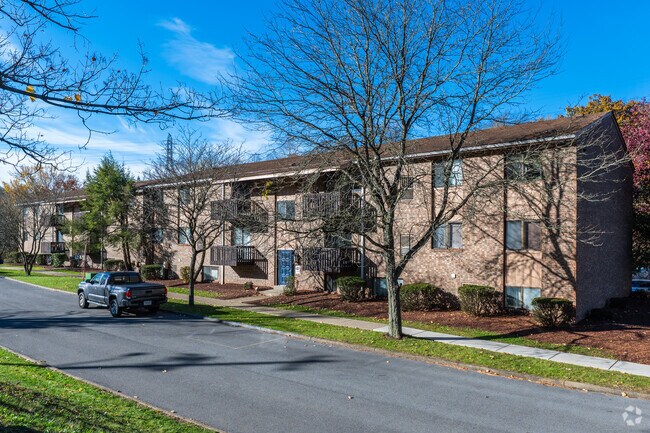
6150 Library Rd
Pittsburgh, PA
Sandy Creek Plan
0887-A-00260-0000-00
SANDY CREEK PLAN #1 IRREG LOT 820.85X309.66X864.43 LIBRARY RD 3-2 STY BRK APT BLDGS #6150-6172
Apartment
Allegheny
AE
Pennsylvania
42125C0220E
260
2024
11.05 AC
2025
Outlying South Allegheny
475304
Pittsburgh
DEMOGRAPHICS near 6150 Library Rd
1 Mile
3 Mile
5 Mile
2024 Total Population
8,494
47,385
132,941
2029 Population
8,359
46,599
130,634
Pop Growth 2024-2029
(1.59%)
(1.66%)
(1.74%)
Average Age
44
44
43
2024 Total Households
3,607
19,061
53,367
HH Growth 2024-2029
(1.69%)
(1.74%)
(1.82%)
Median Household Inc
$94,794
$104,984
$101,588
Avg Household Size
2.30
2.40
2.40
2024 Avg HH Vehicles
2.00
2.00
2.00
Median Home Value
$228,975
$249,256
$259,941
Median Year Built
1971
1970
1967
Nearby Places
Map Layers
Map Styles
 Street
 Aerial
- Restaurants
- Banks
- Shops
- Fitness
- Groceries
PUBLIC TRANSPORTATION
TRANSIT/SUBWAY
Sandy Creek (47L Library - Port Authority of Allegheny County Light Rail (The "T"))
DRIVE
WALK
Distance
Sandy Creek (47L Library - Port Authority of Allegheny County Light Rail (The "T"))
0 min
11 min
0.0 mi
West Library (47L Library - Port Authority of Allegheny County Light Rail (The "T"))
DRIVE
WALK
Distance
West Library (47L Library - Port Authority of Allegheny County Light Rail (The "T"))
0 min
4 min
0.2 mi
Beagle (47L Library - Port Authority of Allegheny County Light Rail (The "T"))
DRIVE
WALK
Distance
Beagle (47L Library - Port Authority of Allegheny County Light Rail (The "T"))
1 min
10 min
0.5 mi
King's School (47L Library - Port Authority of Allegheny County Light Rail (The "T"))
DRIVE
WALK
Distance
King's School (47L Library - Port Authority of Allegheny County Light Rail (The "T"))
2 min
19 min
1.0 mi
AIRPORT
Pittsburgh International
DRIVE
WALK
Distance
Pittsburgh International
42 min
22.1 mi
Freight Ports
Port of Baltimore
DRIVE
WALK
Distance
Port of Baltimore
280 min
241.5 mi
Nearby Properties
Address
Land Use
TOTAL SIZE
Lot Size
Zoning
Address
Land Use
TOTAL SIZE
Lot Size
Zoning
73.76 AC
Address
Land Use
TOTAL SIZE
Lot Size
Zoning
237.75 AC
Address
Land Use
TOTAL SIZE
Lot Size
Zoning
101.91 AC
Address
Land Use
TOTAL SIZE
Lot Size
Zoning
58.24 AC
Address
Land Use
TOTAL SIZE
Lot Size
Zoning
Address
Land Use
TOTAL SIZE
Lot Size
Zoning
11.58 AC
Address
Land Use
TOTAL SIZE
Lot Size
Zoning
16,000 SF
18.37 AC
Address
Land Use
TOTAL SIZE
Lot Size
Zoning
2,179 SF
1,497.30 AC
Address
Land Use
TOTAL SIZE
Lot Size
Zoning
43.24 AC
Address
Land Use
TOTAL SIZE
Lot Size
Zoning
Address
Land Use
TOTAL SIZE
Lot Size
Zoning
9.45 AC
Address
Land Use
TOTAL SIZE
Lot Size
Zoning
Address
Land Use
TOTAL SIZE
Lot Size
Zoning
Address
Land Use
TOTAL SIZE
Lot Size
Zoning
9.70 AC
Address
Land Use
TOTAL SIZE
Lot Size
Zoning
10.54 AC
Address
Land Use
TOTAL SIZE
Lot Size
Zoning
4.42 AC
Address
Land Use
TOTAL SIZE
Lot Size
Zoning
7.04 AC
Address
Land Use
TOTAL SIZE
Lot Size
Zoning
41,000 SF
136.09 AC
Address
Land Use
TOTAL SIZE
Lot Size
Zoning
10.62 AC
Address
Land Use
TOTAL SIZE
Lot Size
Zoning
633.88 AC
Address
Land Use
TOTAL SIZE
Lot Size
Zoning
11.25 AC
Address
Land Use
TOTAL SIZE
Lot Size
Zoning
36.16 AC
Address
Land Use
TOTAL SIZE
Lot Size
Zoning
1.49 AC
Address
Land Use
TOTAL SIZE
Lot Size
Zoning
19.24 AC
Address
Land Use
TOTAL SIZE
Lot Size
Zoning
26,493 SF
4.17 AC
Address
Land Use
TOTAL SIZE
Lot Size
Zoning
16.74 AC
Address
Land Use
TOTAL SIZE
Lot Size
Zoning
5.15 AC
Address
Land Use
TOTAL SIZE
Lot Size
Zoning
Address
Land Use
TOTAL SIZE
Lot Size
Zoning
21.17 AC
Address
Land Use
TOTAL SIZE
Lot Size
Zoning
6.58 AC
The World's #1 Commercial Real Estate Marketplace
Connect with us
© 2026 CoStar Group
The information above has been obtained from sources believed reliable. While we do not doubt its accuracy we have not verified it and make no guarantee, warranty or representation about it. It is your responsibility to independently confirm its accuracy and completeness. Any projections, opinions, assumptions, or estimates used are for example only and do not represent the current or future performance of the property. The value of this transaction to you depends on tax and other factors which should be evaluated by your tax, financial, and legal advisors. You and your advisors should conduct a careful, independent investigation of the property to determine to your satisfaction the suitability of the property for your needs.