Property Record
6150 State Road 70 E, Bradenton, FL 34203
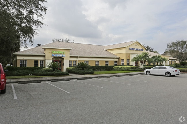

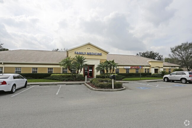
Property Detail
6150 State Road 70 E
17322-2015-9
UNIT C 6150 SR 70 A CONDOMINIUM PI#17322.2015/9
Officecondo
MANATEE
PD-C
Florida
B and X Area of moderate flood hazard, usually the area between the limits of the 100-year and 500-year floods.
c
2024
0.13 AC
2025
Manatee
002005
Tampa/St Petersburg
5,434 SF
North Port-Bradenton-Sarasota, FL
NEARBY LISTINGS FOR SALE OR LEASE
DEMOGRAPHICS near 6150 State Road 70 E
1 mile
3 mile
5 mile
2025 Total Population
5,068
43,501
158,016
2030 Population
5,758
48,635
176,097
Pop Growth 2025-2030
+ 13.61%
+ 11.80%
+ 11.44%
Average Age
56
52
46
2025 Total Households
2,573
19,543
67,154
HH Growth 2025-2030
+ 13.68%
+ 12.02%
+ 11.68%
Median Household Inc
$75,908
$97,491
$86,758
Avg Household Size
1.90
2.20
2.30
2025 Avg HH Vehicles
2.00
2.00
2.00
Median Home Value
$369,078
$460,582
$450,792
Median Year Built
1995
2000
2000
Nearby Places
Map Layers
Map Styles
 Street
 Aerial
Transit
 Traffic
 Biking
Places
Listings with unknown addresses are not visible on the map
- Restaurants
- Banks
- Shops
- Fitness
- Groceries
PUBLIC TRANSPORTATION
AIRPORT
Sarasota/Bradenton International
Drive
Walk
Distance
Sarasota/Bradenton International
18 min
9.8 mi
Freight Ports
Port Manatee
Drive
Walk
Distance
Port Manatee
27 min
18.6 mi
Nearby Properties
Address
Land Use
TOTAL SIZE
Lot Size
Zoning
Address
Land Use
TOTAL SIZE
Lot Size
Zoning
385,610 SF
32.65 AC
RMF-6 MULT
Address
Land Use
TOTAL SIZE
Lot Size
Zoning
483,594 SF
23.32 AC
PD-MU
Address
Land Use
TOTAL SIZE
Lot Size
Zoning
384,346 SF
56.41 AC
PD-PI
Address
Land Use
TOTAL SIZE
Lot Size
Zoning
303,515 SF
36.98 AC
PD-MU
Address
Land Use
TOTAL SIZE
Lot Size
Zoning
241,504 SF
27.72 AC
A GENERAL
Address
Land Use
TOTAL SIZE
Lot Size
Zoning
343,415 SF
31.02 AC
PD-C
Address
Land Use
TOTAL SIZE
Lot Size
Zoning
227,842 SF
12.97 AC
PD-C
Address
Land Use
TOTAL SIZE
Lot Size
Zoning
296,983 SF
34.84 AC
PD-MU
Address
Land Use
TOTAL SIZE
Lot Size
Zoning
29,566 SF
1.17 AC
PD-PI
Address
Land Use
TOTAL SIZE
Lot Size
Zoning
10,389 SF
57.58 AC
PD-RV
Address
Land Use
TOTAL SIZE
Lot Size
Zoning
124,129 SF
23.29 AC
PDC
Address
Land Use
TOTAL SIZE
Lot Size
Zoning
94,206 SF
10.62 AC
PD-C
Address
Land Use
TOTAL SIZE
Lot Size
Zoning
121,771 SF
28.17 AC
A-1 SUBURB
Address
Land Use
TOTAL SIZE
Lot Size
Zoning
310,215 SF
134.06 AC
A GENERAL
Address
Land Use
TOTAL SIZE
Lot Size
Zoning
220,685 SF
27.21 AC
PD-C
Address
Land Use
TOTAL SIZE
Lot Size
Zoning
180,648 SF
21.97 AC
PD-MU
Address
Land Use
TOTAL SIZE
Lot Size
Zoning
10,094 SF
51.90 AC
PD-RV
Address
Land Use
TOTAL SIZE
Lot Size
Zoning
92,466 SF
18.80 AC
A-1 SUBURB
Address
Land Use
TOTAL SIZE
Lot Size
Zoning
88,713 SF
8.70 AC
PD-C
Address
Land Use
TOTAL SIZE
Lot Size
Zoning
160,767 SF
15.63 AC
PD-C
Address
Land Use
TOTAL SIZE
Lot Size
Zoning
53,884 SF
2.33 AC
PD-C
Address
Land Use
TOTAL SIZE
Lot Size
Zoning
104,470 SF
13.22 AC
PD-I
Address
Land Use
TOTAL SIZE
Lot Size
Zoning
66,718 SF
6.56 AC
PD-R
Address
Land Use
TOTAL SIZE
Lot Size
Zoning
114,511 SF
3.53 AC
PD-C
Address
Land Use
TOTAL SIZE
Lot Size
Zoning
78,512 SF
10.59 AC
PD-C,PD-R
Address
Land Use
TOTAL SIZE
Lot Size
Zoning
115,076 SF
8.10 AC
PD-C
Address
Land Use
TOTAL SIZE
Lot Size
Zoning
131,767 SF
21.28 AC
PD-MU
Address
Land Use
TOTAL SIZE
Lot Size
Zoning
115,637 SF
9.31 AC
PD-C
Address
Land Use
TOTAL SIZE
Lot Size
Zoning
112,246 SF
13.01 AC
NC-M NBRHD
Address
Land Use
TOTAL SIZE
Lot Size
Zoning
66,708 SF
29.55 AC
PD-MU
The World's #1 Commercial Real Estate Marketplace
Connect with us
© 2026 CoStar Group
The information above has been obtained from sources believed reliable. While we do not doubt its accuracy we have not verified it and make no guarantee, warranty or representation about it. It is your responsibility to independently confirm its accuracy and completeness. Any projections, opinions, assumptions, or estimates used are for example only and do not represent the current or future performance of the property. The value of this transaction to you depends on tax and other factors which should be evaluated by your tax, financial, and legal advisors. You and your advisors should conduct a careful, independent investigation of the property to determine to your satisfaction the suitability of the property for your needs.