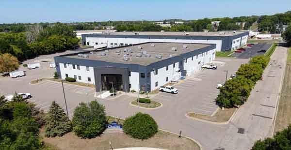
Property Record
6150 W 110Th St, Minneapolis, MN 55438

NEARBY LISTINGS FOR SALE OR LEASE
Property Detail
6150 W 110Th St
Minneapolis-St. Paul-Bloomington, MN-WI
Nesbitt Industrial Park 3Rd Addn
32-116-21-44-0012
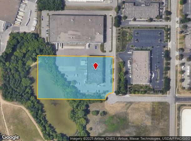
Lot 2, Block 1, Nesbitt Industrial Park 3rd Addition, County of Hennepin, State of Minnesota. Torren
Industrialgeneral
Hennepin
X
Minnesota
27053C0461F
2
2024
5.82 AC
2024
Southwest
025909
Minneapolis/St Paul
DEMOGRAPHICS near 6150 W 110Th St
1 Mile
3 Mile
5 Mile
2024 Total Population
8,806
47,612
160,928
2029 Population
8,704
47,214
162,045
Pop Growth 2024-2029
(1.16%)
(0.84%)
+ 0.69%
Average Age
43
43
41
2024 Total Households
3,670
19,579
65,238
HH Growth 2024-2029
(1.23%)
(0.99%)
+ 0.38%
Median Household Inc
$81,222
$96,088
$93,851
Avg Household Size
2.20
2.30
2.40
2024 Avg HH Vehicles
2.00
2.00
2.00
Median Home Value
$376,721
$357,579
$346,616
Median Year Built
1982
1978
1980
Nearby Places
Map Layers
Map Styles
 Street
 Aerial
- Restaurants
- Banks
- Shops
- Fitness
- Groceries
PUBLIC TRANSPORTATION
AIRPORT
Minneapolis-St Paul International/Wold-Chamberlain
DRIVE
WALK
Distance
Minneapolis-St Paul International/Wold-Chamberlain
21 min
12.1 mi
Freight Ports
Port Milwaukee
DRIVE
WALK
Distance
Port Milwaukee
389 min
349.2 mi
SALE & LEASE HISTORY
LISTING DATE
SALE/LEASE

Sep 21, 2023
For Lease
May 12, 2017
For Lease
Feb 20, 2018
For Sale
Feb 02, 2018
For Lease
Aug 04, 2023
For Sale
Aug 04, 2023
For Lease
Nearby Properties
Address
Land Use
TOTAL SIZE
Lot Size
Zoning
Address
Land Use
TOTAL SIZE
Lot Size
Zoning
114,152 SF
18.42 AC
Address
Land Use
TOTAL SIZE
Lot Size
Zoning
581,195 SF
37 AC
Address
Land Use
TOTAL SIZE
Lot Size
Zoning
105,658 SF
18.80 AC
Address
Land Use
TOTAL SIZE
Lot Size
Zoning
45,147 SF
11.24 AC
Address
Land Use
TOTAL SIZE
Lot Size
Zoning
85,614 SF
11.77 AC
Address
Land Use
TOTAL SIZE
Lot Size
Zoning
88,213 SF
3.77 AC
Address
Land Use
TOTAL SIZE
Lot Size
Zoning
102,132 SF
15.02 AC
Address
Land Use
TOTAL SIZE
Lot Size
Zoning
436,995 SF
22.36 AC
Address
Land Use
TOTAL SIZE
Lot Size
Zoning
70,904 SF
17.42 AC
Address
Land Use
TOTAL SIZE
Lot Size
Zoning
83,736 SF
11.69 AC
Address
Land Use
TOTAL SIZE
Lot Size
Zoning
43,038 SF
10.81 AC
Address
Land Use
TOTAL SIZE
Lot Size
Zoning
310,400 SF
18.60 AC
Address
Land Use
TOTAL SIZE
Lot Size
Zoning
217,534 SF
18.77 AC
Address
Land Use
TOTAL SIZE
Lot Size
Zoning
136,535 SF
4.99 AC
Address
Land Use
TOTAL SIZE
Lot Size
Zoning
122,765 SF
4.58 AC
Address
Land Use
TOTAL SIZE
Lot Size
Zoning
369,600 SF
20.22 AC
Address
Land Use
TOTAL SIZE
Lot Size
Zoning
150,867 SF
100.29 AC
Address
Land Use
TOTAL SIZE
Lot Size
Zoning
47,509 SF
4.64 AC
Address
Land Use
TOTAL SIZE
Lot Size
Zoning
206,005 SF
13.97 AC
Address
Land Use
TOTAL SIZE
Lot Size
Zoning
75,339 SF
3.99 AC
Address
Land Use
TOTAL SIZE
Lot Size
Zoning
153,796 SF
17.93 AC
Address
Land Use
TOTAL SIZE
Lot Size
Zoning
216,770 SF
39.23 AC
Address
Land Use
TOTAL SIZE
Lot Size
Zoning
340,588 SF
16.54 AC
Address
Land Use
TOTAL SIZE
Lot Size
Zoning
131,612 SF
17.80 AC
Address
Land Use
TOTAL SIZE
Lot Size
Zoning
13.99 AC
Address
Land Use
TOTAL SIZE
Lot Size
Zoning
52,466 SF
5.31 AC
Address
Land Use
TOTAL SIZE
Lot Size
Zoning
123,085 SF
10.11 AC
Address
Land Use
TOTAL SIZE
Lot Size
Zoning
131,704 SF
9.83 AC
Address
Land Use
TOTAL SIZE
Lot Size
Zoning
39,160 SF
4.95 AC
Address
Land Use
TOTAL SIZE
Lot Size
Zoning
144,730 SF
14.22 AC
The World's #1 Commercial Real Estate Marketplace
Connect with us
© 2025 CoStar Group
The information above has been obtained from sources believed reliable. While we do not doubt its accuracy we have not verified it and make no guarantee, warranty or representation about it. It is your responsibility to independently confirm its accuracy and completeness. Any projections, opinions, assumptions, or estimates used are for example only and do not represent the current or future performance of the property. The value of this transaction to you depends on tax and other factors which should be evaluated by your tax, financial, and legal advisors. You and your advisors should conduct a careful, independent investigation of the property to determine to your satisfaction the suitability of the property for your needs.