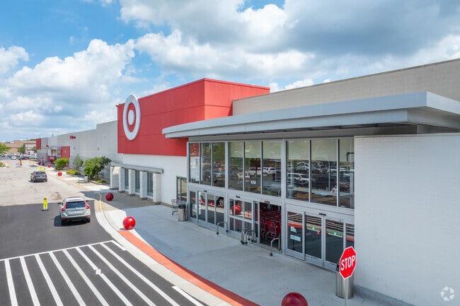
Property Record
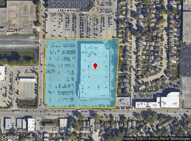
6150 W Touhy Ave, Niles, IL 60714

NEARBY LISTINGS FOR SALE OR LEASE
Property Detail
6150 W Touhy Ave
10-29-307-015-0000
Touhy Avenue Industrial Subdivision
Commercialbuilding
Cook
X
Illinois
17031C0244J
9.92 AC
2023
Near North
2025
Chicago
808100
Chicago-Naperville-Elgin, IL-IN-WI
122,489 SF
DEMOGRAPHICS near 6150 W Touhy Ave
1 Mile
3 Mile
5 Mile
2024 Total Population
6,203
182,732
594,323
2029 Population
5,970
176,612
572,493
Pop Growth 2024-2029
(3.76%)
(3.35%)
(3.67%)
Average Age
45
43
42
2024 Total Households
2,272
67,711
217,926
HH Growth 2024-2029
(4.09%)
(3.73%)
(4.02%)
Median Household Inc
$113,078
$92,607
$84,227
Avg Household Size
2.60
2.60
2.60
2024 Avg HH Vehicles
2.00
2.00
2.00
Median Home Value
$457,738
$373,864
$368,086
Median Year Built
1954
1955
1955
Nearby Places
Map Layers
Map Styles
 Street
 Aerial
- Restaurants
- Banks
- Shops
- Fitness
- Groceries
PUBLIC TRANSPORTATION
AIRPORT
Chicago O'Hare International
DRIVE
WALK
Distance
Chicago O'Hare International
16 min
8.5 mi
Chicago Midway International
DRIVE
WALK
Distance
Chicago Midway International
33 min
18.8 mi
Nearby Properties
Address
Land Use
TOTAL SIZE
Lot Size
Zoning
Address
Land Use
TOTAL SIZE
Lot Size
Zoning
999,808 SF
50.13 AC
Address
Land Use
TOTAL SIZE
Lot Size
Zoning
240,942 SF
15.94 AC
PD 72
Address
Land Use
TOTAL SIZE
Lot Size
Zoning
203,090 SF
7.96 AC
Address
Land Use
TOTAL SIZE
Lot Size
Zoning
24.49 AC
Address
Land Use
TOTAL SIZE
Lot Size
Zoning
Address
Land Use
TOTAL SIZE
Lot Size
Zoning
414,878 SF
20.79 AC
Address
Land Use
TOTAL SIZE
Lot Size
Zoning
172,500 SF
2.42 AC
Address
Land Use
TOTAL SIZE
Lot Size
Zoning
10.24 AC
Address
Land Use
TOTAL SIZE
Lot Size
Zoning
16.27 AC
Address
Land Use
TOTAL SIZE
Lot Size
Zoning
429,949 SF
16.06 AC
Address
Land Use
TOTAL SIZE
Lot Size
Zoning
9.38 AC
PD 1179,PO
Address
Land Use
TOTAL SIZE
Lot Size
Zoning
315,373 SF
26.19 AC
Address
Land Use
TOTAL SIZE
Lot Size
Zoning
92,457 SF
4.09 AC
Address
Land Use
TOTAL SIZE
Lot Size
Zoning
284,708 SF
17.74 AC
Address
Land Use
TOTAL SIZE
Lot Size
Zoning
231,865 SF
3.16 AC
Address
Land Use
TOTAL SIZE
Lot Size
Zoning
43,765 SF
2.79 AC
Address
Land Use
TOTAL SIZE
Lot Size
Zoning
486,884 SF
16.41 AC
Address
Land Use
TOTAL SIZE
Lot Size
Zoning
424,257 SF
Address
Land Use
TOTAL SIZE
Lot Size
Zoning
269,500 SF
11.03 AC
Address
Land Use
TOTAL SIZE
Lot Size
Zoning
98,185 SF
4.66 AC
Address
Land Use
TOTAL SIZE
Lot Size
Zoning
5.60 AC
Address
Land Use
TOTAL SIZE
Lot Size
Zoning
19.42 AC
Address
Land Use
TOTAL SIZE
Lot Size
Zoning
351,666 SF
12.78 AC
Address
Land Use
TOTAL SIZE
Lot Size
Zoning
629,244 SF
11.07 AC
RS-2
Address
Land Use
TOTAL SIZE
Lot Size
Zoning
166,728 SF
11.79 AC
Address
Land Use
TOTAL SIZE
Lot Size
Zoning
43,750 SF
1.19 AC
B1-1
Address
Land Use
TOTAL SIZE
Lot Size
Zoning
320,535 SF
12.44 AC
Address
Land Use
TOTAL SIZE
Lot Size
Zoning
Address
Land Use
TOTAL SIZE
Lot Size
Zoning
358,324 SF
16.05 AC
Address
Land Use
TOTAL SIZE
Lot Size
Zoning
195,849 SF
6.55 AC
The World's #1 Commercial Real Estate Marketplace
Connect with us
© 2026 CoStar Group
The information above has been obtained from sources believed reliable. While we do not doubt its accuracy we have not verified it and make no guarantee, warranty or representation about it. It is your responsibility to independently confirm its accuracy and completeness. Any projections, opinions, assumptions, or estimates used are for example only and do not represent the current or future performance of the property. The value of this transaction to you depends on tax and other factors which should be evaluated by your tax, financial, and legal advisors. You and your advisors should conduct a careful, independent investigation of the property to determine to your satisfaction the suitability of the property for your needs.