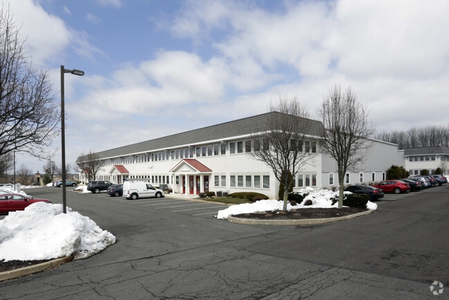
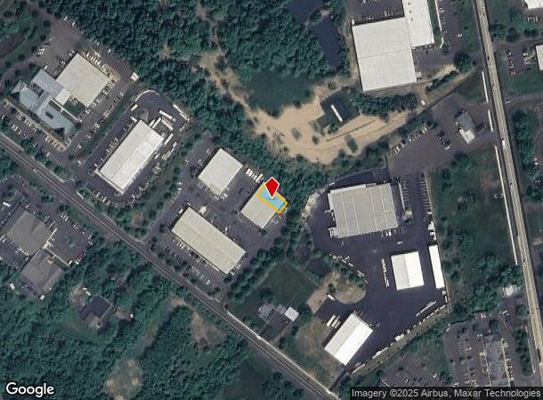
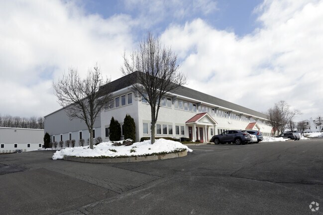
Property Record
6101 Kellers Church Rd, Pipersville, PA 18947

Current Lease Availabilities
NEARBY LISTINGS FOR SALE OR LEASE
-
-
View all Pipersville listings for lease on LoopNet.com
Property Detail
6101 Kellers Church Rd
34-004-007-004-012
Plumstead Commons Condo
Commercialcondominium
UNIT 12 BLDG 3 PLUMSTEAD COMMONS CONDO
X
Bucks
42017C0169J
Pennsylvania
2024
0.09 AC
2025
Bucks
104204
Philadelphia
4,032 SF
Philadelphia-Camden-Wilmington, PA-NJ-DE-MD
DEMOGRAPHICS near 6101 Kellers Church Rd
1 Mile
3 Mile
5 Mile
2024 Total Population
1,876
12,190
35,771
2029 Population
1,857
12,072
35,463
Pop Growth 2024-2029
(1.01%)
(0.97%)
(0.86%)
Average Age
41
41
42
2024 Total Households
637
4,278
13,080
HH Growth 2024-2029
(1.10%)
(1.03%)
(0.87%)
Median Household Inc
$117,788
$125,680
$122,795
Avg Household Size
2.90
2.80
2.70
2024 Avg HH Vehicles
2.00
2.00
2.00
Median Home Value
$444,047
$469,524
$497,492
Median Year Built
1992
1990
1989
Nearby Places
Map Layers
Map Styles
 Street
 Aerial
- Restaurants
- Banks
- Shops
- Fitness
- Groceries
PUBLIC TRANSPORTATION
AIRPORT
Lehigh Valley International
DRIVE
WALK
Distance
Lehigh Valley International
53 min
32.8 mi
Freight Ports
Port of Philadelphia
DRIVE
WALK
Distance
Port of Philadelphia
1 min
28.6 mi
Nearby Properties
Address
Land Use
TOTAL SIZE
Lot Size
Zoning
Address
Land Use
TOTAL SIZE
Lot Size
Zoning
515 SF
128.48 AC
R1
Address
Land Use
TOTAL SIZE
Lot Size
Zoning
66,008 SF
13.28 AC
C3
Address
Land Use
TOTAL SIZE
Lot Size
Zoning
234,274 SF
24.12 AC
C4
Address
Land Use
TOTAL SIZE
Lot Size
Zoning
72,320 SF
17.82 AC
I
Address
Land Use
TOTAL SIZE
Lot Size
Zoning
561,638 SF
36.65 AC
RO
Address
Land Use
TOTAL SIZE
Lot Size
Zoning
61,059 SF
11.43 AC
I
Address
Land Use
TOTAL SIZE
Lot Size
Zoning
25,008 SF
4.05 AC
I
Address
Land Use
TOTAL SIZE
Lot Size
Zoning
78,057 SF
10.50 AC
I
Address
Land Use
TOTAL SIZE
Lot Size
Zoning
36,664 SF
5.10 AC
I
Address
Land Use
TOTAL SIZE
Lot Size
Zoning
49,383 SF
4.45 AC
I
Address
Land Use
TOTAL SIZE
Lot Size
Zoning
32,754 SF
8.03 AC
C2
Address
Land Use
TOTAL SIZE
Lot Size
Zoning
39,541 SF
12.96 AC
I
Address
Land Use
TOTAL SIZE
Lot Size
Zoning
39,797 SF
10.38 AC
C2
Address
Land Use
TOTAL SIZE
Lot Size
Zoning
30,295 SF
4.11 AC
I
Address
Land Use
TOTAL SIZE
Lot Size
Zoning
4,980 SF
3.36 AC
C2
Address
Land Use
TOTAL SIZE
Lot Size
Zoning
49,460 SF
3.03 AC
C4
Address
Land Use
TOTAL SIZE
Lot Size
Zoning
35,152 SF
10.55 AC
C2
Address
Land Use
TOTAL SIZE
Lot Size
Zoning
16,288 SF
3.13 AC
C2
Address
Land Use
TOTAL SIZE
Lot Size
Zoning
64,000 SF
8 AC
C2
Address
Land Use
TOTAL SIZE
Lot Size
Zoning
17,132 SF
35.10 AC
Address
Land Use
TOTAL SIZE
Lot Size
Zoning
19,120 SF
5.13 AC
C2
Address
Land Use
TOTAL SIZE
Lot Size
Zoning
54,680 SF
4.82 AC
I
Address
Land Use
TOTAL SIZE
Lot Size
Zoning
12,000 SF
28.87 AC
I
Address
Land Use
TOTAL SIZE
Lot Size
Zoning
10,875 SF
3.16 AC
C4
Address
Land Use
TOTAL SIZE
Lot Size
Zoning
32,212 SF
24.79 AC
I
Address
Land Use
TOTAL SIZE
Lot Size
Zoning
11,108 SF
3.45 AC
C2
Address
Land Use
TOTAL SIZE
Lot Size
Zoning
19,900 SF
3.19 AC
I
Address
Land Use
TOTAL SIZE
Lot Size
Zoning
2.73 AC
I
Address
Land Use
TOTAL SIZE
Lot Size
Zoning
25,600 SF
2.87 AC
I
The World's #1 Commercial Real Estate Marketplace
Connect with us
© 2025 CoStar Group
The information above has been obtained from sources believed reliable. While we do not doubt its accuracy we have not verified it and make no guarantee, warranty or representation about it. It is your responsibility to independently confirm its accuracy and completeness. Any projections, opinions, assumptions, or estimates used are for example only and do not represent the current or future performance of the property. The value of this transaction to you depends on tax and other factors which should be evaluated by your tax, financial, and legal advisors. You and your advisors should conduct a careful, independent investigation of the property to determine to your satisfaction the suitability of the property for your needs.