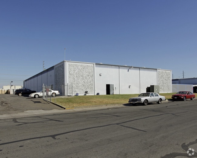
Property Record
6161 27Th St, Sacramento, CA 95822


Current Lease Availabilities
NEARBY LISTINGS FOR SALE OR LEASE
Property Detail
6161 27Th St
036-0052-018
BEING A PORTION OF THE EAST ONE-HALF OF THE SOUTHWEST ONE-QUARTER OF SECTION 30, TOWNSHIP 8 NORTH, RANGE 5 EAST, MOUNT DIABLO
Warehouse
Sacramento
X
California
06067C0190H
2.90 AC
2024
South Sacramento
2025
Sacramento
004100
Sacramento--Roseville--Arden-Arcade, CA
48,100 SF
DEMOGRAPHICS near 6161 27Th St
1 Mile
3 Mile
5 Mile
2024 Total Population
17,261
183,561
399,540
2029 Population
17,396
184,852
403,051
Pop Growth 2024-2029
+ 0.78%
+ 0.70%
+ 0.88%
Average Age
36
38
38
2024 Total Households
5,454
63,355
148,965
HH Growth 2024-2029
+ 0.75%
+ 0.68%
+ 1.02%
Median Household Inc
$53,570
$64,629
$71,510
Avg Household Size
3.10
2.80
2.50
2024 Avg HH Vehicles
2.00
2.00
2.00
Median Home Value
$335,599
$414,408
$460,683
Median Year Built
1961
1964
1970
Nearby Places
Map Layers
Map Styles
 Street
 Aerial
- Restaurants
- Banks
- Shops
- Fitness
- Groceries
PUBLIC TRANSPORTATION
COMMUTER RAIL
DRIVE
WALK
Distance
14 min
8.1 mi
AIRPORT
Sacramento International
DRIVE
WALK
Distance
Sacramento International
29 min
18.9 mi
Freight Ports
Port of Stockton
DRIVE
WALK
Distance
Port of Stockton
53 min
43.1 mi
Nearby Properties
Address
Land Use
TOTAL SIZE
Lot Size
Zoning
Address
Land Use
TOTAL SIZE
Lot Size
Zoning
299,943 SF
4.95 AC
H
Address
Land Use
TOTAL SIZE
Lot Size
Zoning
1.33 AC
R-1
Address
Land Use
TOTAL SIZE
Lot Size
Zoning
1.15 AC
R-1
Address
Land Use
TOTAL SIZE
Lot Size
Zoning
12.70 AC
SC-PUD
Address
Land Use
TOTAL SIZE
Lot Size
Zoning
253,984 SF
11.58 AC
R-2B-PUD
Address
Land Use
TOTAL SIZE
Lot Size
Zoning
2.59 AC
OB-R
Address
Land Use
TOTAL SIZE
Lot Size
Zoning
1.15 AC
R-1
Address
Land Use
TOTAL SIZE
Lot Size
Zoning
213,260 SF
14.35 AC
R-3-R
Address
Land Use
TOTAL SIZE
Lot Size
Zoning
53,386 SF
7.75 AC
C-2-SPD
Address
Land Use
TOTAL SIZE
Lot Size
Zoning
64,082 SF
2.38 AC
R-1
Address
Land Use
TOTAL SIZE
Lot Size
Zoning
213,445 SF
18.25 AC
SC
Address
Land Use
TOTAL SIZE
Lot Size
Zoning
267,580 SF
16.12 AC
R-1A
Address
Land Use
TOTAL SIZE
Lot Size
Zoning
58.59 AC
R-1
Address
Land Use
TOTAL SIZE
Lot Size
Zoning
122,668 SF
3.10 AC
C-4 R-3 R-
Address
Land Use
TOTAL SIZE
Lot Size
Zoning
66,372 SF
0.38 AC
C-2
Address
Land Use
TOTAL SIZE
Lot Size
Zoning
Address
Land Use
TOTAL SIZE
Lot Size
Zoning
102,930 SF
4.87 AC
R-3
Address
Land Use
TOTAL SIZE
Lot Size
Zoning
181,766 SF
4.79 AC
R-4-PUD R-
Address
Land Use
TOTAL SIZE
Lot Size
Zoning
95,548 SF
24.25 AC
R-1
Address
Land Use
TOTAL SIZE
Lot Size
Zoning
227,396 SF
15.76 AC
R-2A-R-EA-
Address
Land Use
TOTAL SIZE
Lot Size
Zoning
91,586 SF
6.03 AC
R-3-R
Address
Land Use
TOTAL SIZE
Lot Size
Zoning
95,427 SF
7.07 AC
LC
Address
Land Use
TOTAL SIZE
Lot Size
Zoning
100,704 SF
5.63 AC
RD-20
Address
Land Use
TOTAL SIZE
Lot Size
Zoning
84,087 SF
4.11 AC
R-3-R
Address
Land Use
TOTAL SIZE
Lot Size
Zoning
162,259 SF
12.73 AC
R-3
Address
Land Use
TOTAL SIZE
Lot Size
Zoning
100,787 SF
8.78 AC
SPA
Address
Land Use
TOTAL SIZE
Lot Size
Zoning
53,967 SF
8.77 AC
SC-PUD
Address
Land Use
TOTAL SIZE
Lot Size
Zoning
129,305 SF
9.37 AC
C-2-SPD
Address
Land Use
TOTAL SIZE
Lot Size
Zoning
55,537 SF
3.67 AC
SC-PUD
Address
Land Use
TOTAL SIZE
Lot Size
Zoning
85,429 SF
3.67 AC
F C-2-R
The World's #1 Commercial Real Estate Marketplace
Connect with us
© 2025 CoStar Group
The information above has been obtained from sources believed reliable. While we do not doubt its accuracy we have not verified it and make no guarantee, warranty or representation about it. It is your responsibility to independently confirm its accuracy and completeness. Any projections, opinions, assumptions, or estimates used are for example only and do not represent the current or future performance of the property. The value of this transaction to you depends on tax and other factors which should be evaluated by your tax, financial, and legal advisors. You and your advisors should conduct a careful, independent investigation of the property to determine to your satisfaction the suitability of the property for your needs.