Property Record
6155 Highway 90, Milton, FL 32570

NEARBY LISTINGS FOR SALE OR LEASE
-
-
View all Milton listings for sale on LoopNet.com
Property Detail
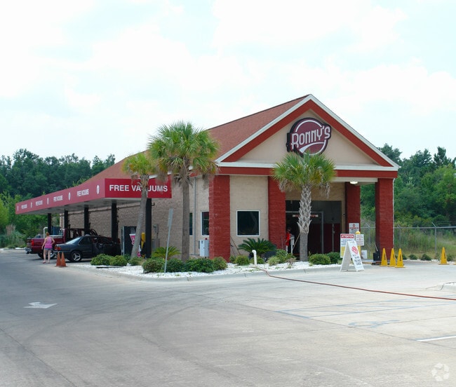
6155 Highway 90
08-1N-28-0000-01200-0000
COM 540.3 FT S54*57 W OF PT 120.22 FT S OF NE CORN SE4 SE4 TH S35*03E 200 FT TH S54*57W 200 FT TO POB TH S35*03E 200 FT TH S54*57W 200 FT TH N35* 03W 400 FT TO S LI HWY 90 TH N 54*57E 200 FT TH S35*03E 200 FT TO POB AS DES IN OR 3692 PG 1840 (LEGAL D
Carwash
Santa Rosa
X
Florida
12113C0427H
1.03 AC
2024
Avalon Beach/Milton
2025
Pensacola
010712
Pensacola-Ferry Pass-Brent, FL
8,670 SF
DEMOGRAPHICS near 6155 Highway 90
1 Mile
3 Mile
5 Mile
2024 Total Population
3,349
29,462
58,561
2029 Population
3,830
33,732
67,248
Pop Growth 2024-2029
+ 14.36%
+ 14.49%
+ 14.83%
Average Age
39
40
40
2024 Total Households
1,261
11,399
22,459
HH Growth 2024-2029
+ 14.67%
+ 14.83%
+ 15.17%
Median Household Inc
$73,348
$73,027
$72,770
Avg Household Size
2.60
2.50
2.60
2024 Avg HH Vehicles
2.00
2.00
2.00
Median Home Value
$157,967
$214,426
$226,328
Median Year Built
1990
1990
1992
Nearby Places
Map Layers
Map Styles
 Street
 Aerial
- Restaurants
- Banks
- Shops
- Fitness
- Groceries
PUBLIC TRANSPORTATION
AIRPORT
Pensacola International
DRIVE
WALK
Distance
Pensacola International
27 min
17.3 mi
Freight Ports
Port of Mobile
DRIVE
WALK
Distance
Port of Mobile
1 min
58.2 mi
SALE & LEASE HISTORY
LISTING DATE
SALE/LEASE

Dec 29, 2022
For Sale
Nearby Properties
Address
Land Use
TOTAL SIZE
Lot Size
Zoning
Address
Land Use
TOTAL SIZE
Lot Size
Zoning
118,887 SF
19.24 AC
HCD
Address
Land Use
TOTAL SIZE
Lot Size
Zoning
173,250 SF
28.91 AC
C1
Address
Land Use
TOTAL SIZE
Lot Size
Zoning
8,223 SF
40 AC
Address
Land Use
TOTAL SIZE
Lot Size
Zoning
130,603 SF
14.30 AC
R2
Address
Land Use
TOTAL SIZE
Lot Size
Zoning
102,921 SF
5 AC
R3
Address
Land Use
TOTAL SIZE
Lot Size
Zoning
113,178 SF
8.61 AC
HCD
Address
Land Use
TOTAL SIZE
Lot Size
Zoning
151,842 SF
14.28 AC
C2
Address
Land Use
TOTAL SIZE
Lot Size
Zoning
113,652 SF
9.52 AC
C2
Address
Land Use
TOTAL SIZE
Lot Size
Zoning
199,775 SF
8.83 AC
HCD
Address
Land Use
TOTAL SIZE
Lot Size
Zoning
113,899 SF
3.05 AC
HCD
Address
Land Use
TOTAL SIZE
Lot Size
Zoning
82,878 SF
9.07 AC
HCD
Address
Land Use
TOTAL SIZE
Lot Size
Zoning
76.81 AC
R1
Address
Land Use
TOTAL SIZE
Lot Size
Zoning
98,250 SF
49.63 AC
HCD
Address
Land Use
TOTAL SIZE
Lot Size
Zoning
147,443 SF
11.44 AC
I1
Address
Land Use
TOTAL SIZE
Lot Size
Zoning
39,570 SF
0.36 AC
C1
Address
Land Use
TOTAL SIZE
Lot Size
Zoning
81,150 SF
4.86 AC
HCD
Address
Land Use
TOTAL SIZE
Lot Size
Zoning
68,026 SF
2.07 AC
RC1
Address
Land Use
TOTAL SIZE
Lot Size
Zoning
48,210 SF
8.98 AC
C2
Address
Land Use
TOTAL SIZE
Lot Size
Zoning
115,095 SF
7.44 AC
HCD
Address
Land Use
TOTAL SIZE
Lot Size
Zoning
16,903 SF
11 AC
AG-RR
Address
Land Use
TOTAL SIZE
Lot Size
Zoning
91,887 SF
10.83 AC
C1
Address
Land Use
TOTAL SIZE
Lot Size
Zoning
10 AC
R1A
Address
Land Use
TOTAL SIZE
Lot Size
Zoning
9.61 AC
R1
Address
Land Use
TOTAL SIZE
Lot Size
Zoning
37,820 SF
16.98 AC
HCD
Address
Land Use
TOTAL SIZE
Lot Size
Zoning
51,760 SF
5.50 AC
HCD
Address
Land Use
TOTAL SIZE
Lot Size
Zoning
40,142 SF
5.28 AC
R3
Address
Land Use
TOTAL SIZE
Lot Size
Zoning
41,105 SF
8.16 AC
HCD
Address
Land Use
TOTAL SIZE
Lot Size
Zoning
43,312 SF
15 AC
HCD
Address
Land Use
TOTAL SIZE
Lot Size
Zoning
46,613 SF
5.72 AC
C1
The World's #1 Commercial Real Estate Marketplace
Connect with us
© 2025 CoStar Group
The information above has been obtained from sources believed reliable. While we do not doubt its accuracy we have not verified it and make no guarantee, warranty or representation about it. It is your responsibility to independently confirm its accuracy and completeness. Any projections, opinions, assumptions, or estimates used are for example only and do not represent the current or future performance of the property. The value of this transaction to you depends on tax and other factors which should be evaluated by your tax, financial, and legal advisors. You and your advisors should conduct a careful, independent investigation of the property to determine to your satisfaction the suitability of the property for your needs.