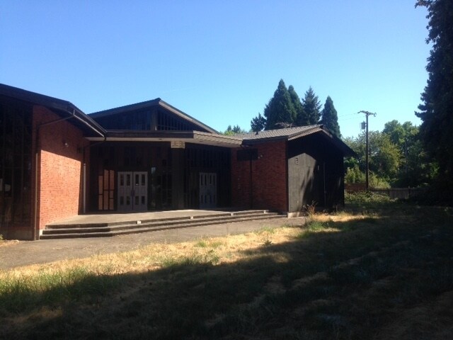
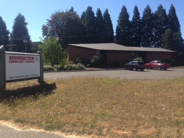
Property Record
6155 Thurston Rd, Springfield, OR 97478


Property Detail
6155 Thurston Rd
Eugene-Springfield, OR
PARTITION PLAT 2000-P1387 PCL 1 TL 00511
1666807
Lane
Commercialnec
Oregon
LD
511
B and X Area of moderate flood hazard, usually the area between the limits of the 100-year and 500-year floods.
1.52 AC
0
Lane County
2025
Portland
001803
NEARBY LISTINGS FOR SALE OR LEASE
-
-
View all Springfield listings for sale on LoopNet.com
DEMOGRAPHICS near 6155 Thurston Rd
1 mile
3 mile
5 mile
2025 Total Population
9,770
30,371
53,814
2030 Population
9,642
30,059
53,300
Pop Growth 2025-2030
(1.31%)
(1.03%)
(0.96%)
Average Age
41
40
41
2025 Total Households
3,659
11,264
20,760
HH Growth 2025-2030
(1.45%)
(1.14%)
(1.03%)
Median Household Inc
$77,317
$78,794
$76,755
Avg Household Size
2.60
2.60
2.50
2025 Avg HH Vehicles
2.00
2.00
2.00
Median Home Value
$381,317
$377,419
$383,951
Median Year Built
1977
1979
1975
Nearby Places
Map Layers
Map Styles
 Street
 Aerial
Layers
 Traffic
 Biking
Places
Listings with unknown addresses are not visible on the map
- Restaurants
- Banks
- Shops
- Fitness
- Groceries
PUBLIC TRANSPORTATION
COMMUTER RAIL
Drive
Walk
Distance
16 min
9.5 mi
AIRPORT
Mahlon Sweet Field
Drive
Walk
Distance
Mahlon Sweet Field
30 min
18.1 mi
SALE & LEASE HISTORY
LISTING DATE
SALE/LEASE

Sep 23, 2016
For Sale
Nearby Properties
Address
Land Use
TOTAL SIZE
Lot Size
Zoning
Address
Land Use
TOTAL SIZE
Lot Size
Zoning
Address
Land Use
TOTAL SIZE
Lot Size
Zoning
179 AC
E30
Address
Land Use
TOTAL SIZE
Lot Size
Zoning
50.28 AC
LD
Address
Land Use
TOTAL SIZE
Lot Size
Zoning
27.44 AC
LD
Address
Land Use
TOTAL SIZE
Lot Size
Zoning
11.12 AC
HI
Address
Land Use
TOTAL SIZE
Lot Size
Zoning
5.39 AC
LD
Address
Land Use
TOTAL SIZE
Lot Size
Zoning
3.58 AC
HD
Address
Land Use
TOTAL SIZE
Lot Size
Zoning
13.84 AC
HD
Address
Land Use
TOTAL SIZE
Lot Size
Zoning
9.23 AC
LD
Address
Land Use
TOTAL SIZE
Lot Size
Zoning
18.70 AC
E30
Address
Land Use
TOTAL SIZE
Lot Size
Zoning
7.78 AC
LD
Address
Land Use
TOTAL SIZE
Lot Size
Zoning
5.88 AC
LD
Address
Land Use
TOTAL SIZE
Lot Size
Zoning
119.04 AC
E30
Address
Land Use
TOTAL SIZE
Lot Size
Zoning
4.47 AC
CC
Address
Land Use
TOTAL SIZE
Lot Size
Zoning
8.06 AC
HD
Address
Land Use
TOTAL SIZE
Lot Size
Zoning
7.79 AC
E30
Address
Land Use
TOTAL SIZE
Lot Size
Zoning
9.93 AC
LD
Address
Land Use
TOTAL SIZE
Lot Size
Zoning
32.97 AC
E30
Address
Land Use
TOTAL SIZE
Lot Size
Zoning
3.49 AC
HI
Address
Land Use
TOTAL SIZE
Lot Size
Zoning
46.87 AC
E30
Address
Land Use
TOTAL SIZE
Lot Size
Zoning
2.20 AC
HD
Address
Land Use
TOTAL SIZE
Lot Size
Zoning
5.63 AC
LD
Address
Land Use
TOTAL SIZE
Lot Size
Zoning
3.28 AC
CC
Address
Land Use
TOTAL SIZE
Lot Size
Zoning
1,312 SF
4.93 AC
CC
Address
Land Use
TOTAL SIZE
Lot Size
Zoning
4.68 AC
CC
Address
Land Use
TOTAL SIZE
Lot Size
Zoning
132.96 AC
E30
Address
Land Use
TOTAL SIZE
Lot Size
Zoning
3.59 AC
CC
Address
Land Use
TOTAL SIZE
Lot Size
Zoning
3.36 AC
CC
Address
Land Use
TOTAL SIZE
Lot Size
Zoning
11.28 AC
LD
Address
Land Use
TOTAL SIZE
Lot Size
Zoning
12.89 AC
LD
The World's #1 Commercial Real Estate Marketplace
Connect with us
© 2026 CoStar Group
The information above has been obtained from sources believed reliable. While we do not doubt its accuracy we have not verified it and make no guarantee, warranty or representation about it. It is your responsibility to independently confirm its accuracy and completeness. Any projections, opinions, assumptions, or estimates used are for example only and do not represent the current or future performance of the property. The value of this transaction to you depends on tax and other factors which should be evaluated by your tax, financial, and legal advisors. You and your advisors should conduct a careful, independent investigation of the property to determine to your satisfaction the suitability of the property for your needs.