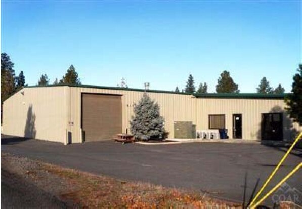
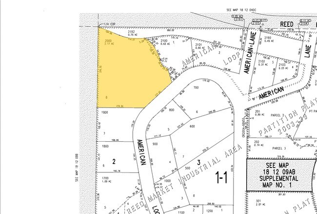
Property Record
61573 American Loop, Bend, OR 97702

Property Detail
61573 American Loop
159675
REED MARKET INDUSTRIAL AREA BLOCK 2 LOT 8
Industrialgeneral
Deschutes
IL
Oregon
B and X Area of moderate flood hazard, usually the area between the limits of the 100-year and 500-year floods.
8
2025
2.17 AC
2025
Deschutes County
002002
Portland
30,357 SF
Bend, OR
NEARBY LISTINGS FOR SALE OR LEASE
DEMOGRAPHICS near 61573 American Loop
1 mile
3 mile
5 mile
2025 Total Population
11,762
70,586
108,762
2030 Population
12,011
72,199
111,388
Pop Growth 2025-2030
+ 2.12%
+ 2.29%
+ 2.41%
Average Age
38
41
41
2025 Total Households
4,784
29,517
44,273
HH Growth 2025-2030
+ 2.01%
+ 2.25%
+ 2.39%
Median Household Inc
$80,866
$93,386
$102,485
Avg Household Size
2.40
2.30
2.40
2025 Avg HH Vehicles
2.00
2.00
2.00
Median Home Value
$581,967
$718,350
$760,488
Median Year Built
1997
1998
2000
Nearby Places
Map Layers
Map Styles
 Street
 Aerial
Transit
 Traffic
 Biking
Places
Listings with unknown addresses are not visible on the map
- Restaurants
- Banks
- Shops
- Fitness
- Groceries
PUBLIC TRANSPORTATION
AIRPORT
Roberts Field
Drive
Walk
Distance
Roberts Field
29 min
18.8 mi
Freight Ports
Port of Portland
Drive
Walk
Distance
Port of Portland
237 min
180.3 mi
Nearby Properties
Address
Land Use
TOTAL SIZE
Lot Size
Zoning
Address
Land Use
TOTAL SIZE
Lot Size
Zoning
61,869 SF
35.14 AC
RH
Address
Land Use
TOTAL SIZE
Lot Size
Zoning
35.14 AC
Address
Land Use
TOTAL SIZE
Lot Size
Zoning
116,476 SF
35.14 AC
RH
Address
Land Use
TOTAL SIZE
Lot Size
Zoning
10,490 SF
35.14 AC
RH
Address
Land Use
TOTAL SIZE
Lot Size
Zoning
144,000 SF
35.14 AC
RH
Address
Land Use
TOTAL SIZE
Lot Size
Zoning
35.14 AC
RH
Address
Land Use
TOTAL SIZE
Lot Size
Zoning
144,000 SF
35.14 AC
RH
Address
Land Use
TOTAL SIZE
Lot Size
Zoning
35.14 AC
RH
Address
Land Use
TOTAL SIZE
Lot Size
Zoning
11,947 SF
35.14 AC
RH
Address
Land Use
TOTAL SIZE
Lot Size
Zoning
35.14 AC
RH
Address
Land Use
TOTAL SIZE
Lot Size
Zoning
35.14 AC
Address
Land Use
TOTAL SIZE
Lot Size
Zoning
35.14 AC
RH
Address
Land Use
TOTAL SIZE
Lot Size
Zoning
35.14 AC
RH
Address
Land Use
TOTAL SIZE
Lot Size
Zoning
35.14 AC
RH
Address
Land Use
TOTAL SIZE
Lot Size
Zoning
144,000 SF
35.14 AC
RH
Address
Land Use
TOTAL SIZE
Lot Size
Zoning
35.14 AC
Address
Land Use
TOTAL SIZE
Lot Size
Zoning
35.14 AC
RH
Address
Land Use
TOTAL SIZE
Lot Size
Zoning
3.74 AC
MR
Address
Land Use
TOTAL SIZE
Lot Size
Zoning
25,574 SF
3.74 AC
MR
Address
Land Use
TOTAL SIZE
Lot Size
Zoning
27,863 SF
4.23 AC
MU
Address
Land Use
TOTAL SIZE
Lot Size
Zoning
318,598 SF
9.77 AC
RS
Address
Land Use
TOTAL SIZE
Lot Size
Zoning
201,150 SF
3.75 AC
RH
Address
Land Use
TOTAL SIZE
Lot Size
Zoning
166,371 SF
2.52 AC
MU
Address
Land Use
TOTAL SIZE
Lot Size
Zoning
199,892 SF
19.16 AC
CG
Address
Land Use
TOTAL SIZE
Lot Size
Zoning
115,973 SF
73.55 AC
UA
Address
Land Use
TOTAL SIZE
Lot Size
Zoning
1.04 AC
CB
Address
Land Use
TOTAL SIZE
Lot Size
Zoning
201,575 SF
1.04 AC
CB
Address
Land Use
TOTAL SIZE
Lot Size
Zoning
165,048 SF
4.68 AC
RM
Address
Land Use
TOTAL SIZE
Lot Size
Zoning
1,248 SF
5.04 AC
RM
Address
Land Use
TOTAL SIZE
Lot Size
Zoning
129,449 SF
2.91 AC
MR
The World's #1 Commercial Real Estate Marketplace
Connect with us
© 2026 CoStar Group
The information above has been obtained from sources believed reliable. While we do not doubt its accuracy we have not verified it and make no guarantee, warranty or representation about it. It is your responsibility to independently confirm its accuracy and completeness. Any projections, opinions, assumptions, or estimates used are for example only and do not represent the current or future performance of the property. The value of this transaction to you depends on tax and other factors which should be evaluated by your tax, financial, and legal advisors. You and your advisors should conduct a careful, independent investigation of the property to determine to your satisfaction the suitability of the property for your needs.