Property Record
616 E Main St, Lansdale, PA 19446

Save to a Folder
{{folder.Name}}
{{folder.ListingIds.length}} Properties
{{folder.ListingIds.length}} Property
Create a New Folder
Property Detail
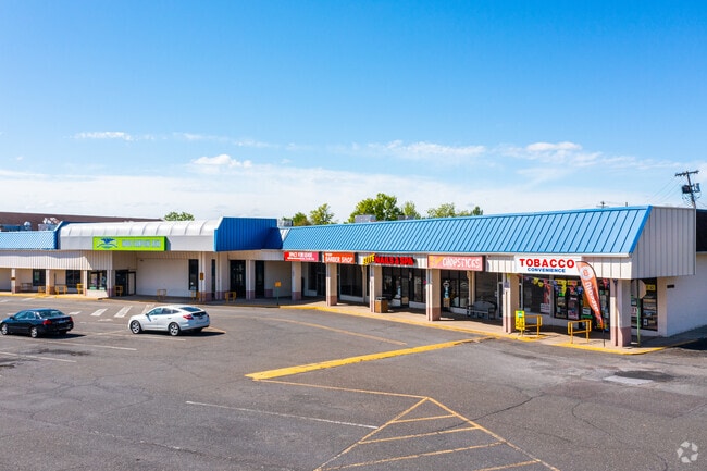
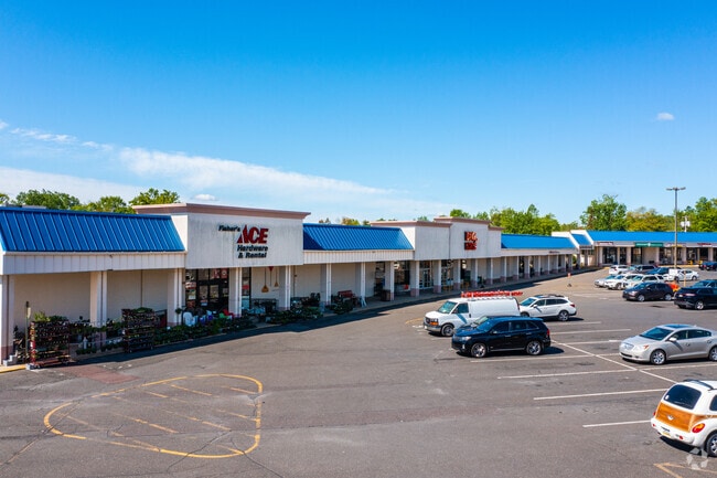
616 E Main St
11-00-10284-001
ASSESSOR BLOCK-UNIT NUMBER 52-32
Regionalshoppingcenterormallwithanchorstore
MONTGOMERY
C
Pennsylvania
B and X Area of moderate flood hazard, usually the area between the limits of the 100-year and 500-year floods.
32
2026
11.99 AC
2026
West Montgomery County
200903
Philadelphia
161,256 SF
Philadelphia-Camden-Wilmington, PA-NJ-DE-MD
NEARBY LISTINGS FOR SALE OR LEASE
DEMOGRAPHICS near 616 E Main St
1 mile
3 mile
5 mile
2025 Total Population
14,969
77,293
156,205
2030 Population
15,205
78,408
159,909
Pop Growth 2025-2030
+ 1.58%
+ 1.44%
+ 2.37%
Average Age
41
43
43
2025 Total Households
5,905
30,123
59,712
HH Growth 2025-2030
+ 1.49%
+ 1.36%
+ 2.22%
Median Household Inc
$88,326
$105,388
$111,446
Avg Household Size
2.40
2.50
2.50
2025 Avg HH Vehicles
2.00
2.00
2.00
Median Home Value
$375,299
$447,882
$483,829
Median Year Built
1965
1977
1982
Nearby Places
Map Layers
Map Styles
 Street
 Aerial
Layers
 Traffic
 Biking
Places
Listings with unknown addresses are not visible on the map
- Restaurants
- Banks
- Shops
- Fitness
- Groceries
PUBLIC TRANSPORTATION
COMMUTER RAIL
Pennbrook (R5 - Southeastern Pennsylvania Transportation Authority Regional Rail (SEPTA Regional Rail))
Drive
Walk
Distance
Pennbrook (R5 - Southeastern Pennsylvania Transportation Authority Regional Rail (SEPTA Regional Rail))
3 min
16 min
0.9 mi
Lansdale (R5 - Southeastern Pennsylvania Transportation Authority Regional Rail (SEPTA Regional Rail))
Drive
Walk
Distance
Lansdale (R5 - Southeastern Pennsylvania Transportation Authority Regional Rail (SEPTA Regional Rail))
3 min
19 min
1.0 mi
AIRPORT
Trenton Mercer
Drive
Walk
Distance
Trenton Mercer
56 min
35.6 mi
Philadelphia International
Drive
Walk
Distance
Philadelphia International
57 min
38.3 mi
Freight Ports
Port of Philadelphia
Drive
Walk
Distance
Port of Philadelphia
38 min
22.8 mi
SALE & LEASE HISTORY
LISTING DATE
SALE/LEASE

Sep 25, 2016
For Lease
Jul 24, 2025
For Sale
Jul 09, 2018
For Lease
Nearby Properties
Address
Land Use
TOTAL SIZE
Lot Size
Zoning
Address
Land Use
TOTAL SIZE
Lot Size
Zoning
7,622,512 SF
315.44 AC
LI
Address
Land Use
TOTAL SIZE
Lot Size
Zoning
1,727,070 SF
91.78 AC
LI
Address
Land Use
TOTAL SIZE
Lot Size
Zoning
519,907 SF
91.44 AC
R125
Address
Land Use
TOTAL SIZE
Lot Size
Zoning
258,179 SF
65.34 AC
IN
Address
Land Use
TOTAL SIZE
Lot Size
Zoning
404,986 SF
22.21 AC
I
Address
Land Use
TOTAL SIZE
Lot Size
Zoning
268,288 SF
30.59 AC
RA
Address
Land Use
TOTAL SIZE
Lot Size
Zoning
444,426 SF
30 AC
GA
Address
Land Use
TOTAL SIZE
Lot Size
Zoning
629,336 SF
31.74 AC
IN
Address
Land Use
TOTAL SIZE
Lot Size
Zoning
1,127,663 SF
14.16 AC
RS
Address
Land Use
TOTAL SIZE
Lot Size
Zoning
657,589 SF
100.81 AC
MF3A
Address
Land Use
TOTAL SIZE
Lot Size
Zoning
264,549 SF
40.75 AC
E
Address
Land Use
TOTAL SIZE
Lot Size
Zoning
319,136 SF
18.35 AC
HDR
Address
Land Use
TOTAL SIZE
Lot Size
Zoning
301,431 SF
41.90 AC
S
Address
Land Use
TOTAL SIZE
Lot Size
Zoning
517,834 SF
31.33 AC
GA
Address
Land Use
TOTAL SIZE
Lot Size
Zoning
283,615 SF
9.43 AC
LI
Address
Land Use
TOTAL SIZE
Lot Size
Zoning
245,104 SF
31.21 AC
C
Address
Land Use
TOTAL SIZE
Lot Size
Zoning
203,378 SF
24.65 AC
RC
Address
Land Use
TOTAL SIZE
Lot Size
Zoning
225,154 SF
6.38 AC
B
Address
Land Use
TOTAL SIZE
Lot Size
Zoning
985,663 SF
64.82 AC
RC
Address
Land Use
TOTAL SIZE
Lot Size
Zoning
334,450 SF
18.86 AC
GA
Address
Land Use
TOTAL SIZE
Lot Size
Zoning
139,081 SF
15.20 AC
LI
Address
Land Use
TOTAL SIZE
Lot Size
Zoning
142,336 SF
3.17 AC
RS
Address
Land Use
TOTAL SIZE
Lot Size
Zoning
131,631 SF
18.12 AC
SC
Address
Land Use
TOTAL SIZE
Lot Size
Zoning
337,074 SF
12.92 AC
A
Address
Land Use
TOTAL SIZE
Lot Size
Zoning
289,681 SF
4.75 AC
BPO
Address
Land Use
TOTAL SIZE
Lot Size
Zoning
233,730 SF
19.10 AC
GA
Address
Land Use
TOTAL SIZE
Lot Size
Zoning
333,600 SF
24.72 AC
LI
Address
Land Use
TOTAL SIZE
Lot Size
Zoning
256,889 SF
4.05 AC
I
Address
Land Use
TOTAL SIZE
Lot Size
Zoning
216,017 SF
16 AC
GA
Address
Land Use
TOTAL SIZE
Lot Size
Zoning
207,306 SF
14.50 AC
GA
The World's #1 Commercial Real Estate Marketplace
Connect with us
© 2026 CoStar Group
The information above has been obtained from sources believed reliable. While we do not doubt its accuracy we have not verified it and make no guarantee, warranty or representation about it. It is your responsibility to independently confirm its accuracy and completeness. Any projections, opinions, assumptions, or estimates used are for example only and do not represent the current or future performance of the property. The value of this transaction to you depends on tax and other factors which should be evaluated by your tax, financial, and legal advisors. You and your advisors should conduct a careful, independent investigation of the property to determine to your satisfaction the suitability of the property for your needs.