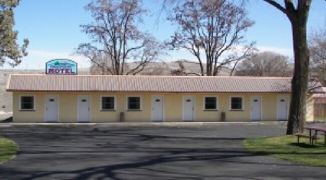
Property Record
616 Mill St, Maupin, OR 97037

Property Detail
616 Mill St
The Dalles, OR
SECTION 32 TOWNSHIP 4S RANGE 14E QUARTER CD PRCL 1900 MAPTAX LOT: 04S14 E32CD01900 00
11886
Wasco
Commercialnec
Oregon
RC
0.41 AC
2025
Oregon East Area
2025
Other Market Areas
970800
NEARBY LISTINGS FOR SALE OR LEASE
-
-
View all Maupin listings for sale on LoopNet.com
DEMOGRAPHICS near 616 Mill St
1 mile
3 mile
5 mile
2025 Total Population
767
809
845
2030 Population
806
850
888
Pop Growth 2025-2030
+ 5.08%
+ 5.07%
+ 5.09%
Average Age
49
49
49
2025 Total Households
337
355
372
HH Growth 2025-2030
+ 5.04%
+ 5.07%
+ 4.84%
Median Household Inc
$57,045
$56,521
$57,083
Avg Household Size
2.20
2.20
2.20
2025 Avg HH Vehicles
2.00
2.00
2.00
Median Home Value
$319,388
$318,627
$319,444
Median Year Built
1981
1981
1981
Nearby Places
Map Layers
Map Styles
 Street
 Aerial
Layers
 Traffic
 Biking
Places
Listings with unknown addresses are not visible on the map
- Restaurants
- Banks
- Shops
- Fitness
- Groceries
SALE & LEASE HISTORY
LISTING DATE
SALE/LEASE

Sep 22, 2017
For Sale
Sep 22, 2017
For Sale
Dec 03, 2023
For Sale
Apr 16, 2019
For Sale
Nearby Properties
Address
Land Use
TOTAL SIZE
Lot Size
Zoning
Address
Land Use
TOTAL SIZE
Lot Size
Zoning
2.41 AC
Address
Land Use
TOTAL SIZE
Lot Size
Zoning
3.58 AC
LDR
Address
Land Use
TOTAL SIZE
Lot Size
Zoning
1.75 AC
MDR
Address
Land Use
TOTAL SIZE
Lot Size
Zoning
1,340 SF
0.17 AC
MDR
Address
Land Use
TOTAL SIZE
Lot Size
Zoning
4,768 SF
14.50 AC
A180
Address
Land Use
TOTAL SIZE
Lot Size
Zoning
0.12 AC
MDR
Address
Land Use
TOTAL SIZE
Lot Size
Zoning
4.06 AC
HDR
Address
Land Use
TOTAL SIZE
Lot Size
Zoning
2,959 SF
586.66 AC
Address
Land Use
TOTAL SIZE
Lot Size
Zoning
7,955 SF
288.79 AC
A180
Address
Land Use
TOTAL SIZE
Lot Size
Zoning
0.41 AC
Address
Land Use
TOTAL SIZE
Lot Size
Zoning
4.93 AC
I INDUSTRI
Address
Land Use
TOTAL SIZE
Lot Size
Zoning
3,624 SF
0.32 AC
RC
Address
Land Use
TOTAL SIZE
Lot Size
Zoning
3,572 SF
832.81 AC
A180
Address
Land Use
TOTAL SIZE
Lot Size
Zoning
6.14 AC
I INDUSTRI
Address
Land Use
TOTAL SIZE
Lot Size
Zoning
0.88 AC
RC
Address
Land Use
TOTAL SIZE
Lot Size
Zoning
0.13 AC
GC
Address
Land Use
TOTAL SIZE
Lot Size
Zoning
784.02 AC
A180
Address
Land Use
TOTAL SIZE
Lot Size
Zoning
0.46 AC
GC
Address
Land Use
TOTAL SIZE
Lot Size
Zoning
5,040 SF
120 AC
A180
Address
Land Use
TOTAL SIZE
Lot Size
Zoning
2,308 SF
158.18 AC
A180
Address
Land Use
TOTAL SIZE
Lot Size
Zoning
1,419 SF
0.34 AC
RC
Address
Land Use
TOTAL SIZE
Lot Size
Zoning
1,409 SF
1.98 AC
MDR
Address
Land Use
TOTAL SIZE
Lot Size
Zoning
0.45 AC
RC
Address
Land Use
TOTAL SIZE
Lot Size
Zoning
0.41 AC
MDR
Address
Land Use
TOTAL SIZE
Lot Size
Zoning
0.23 AC
GC
Address
Land Use
TOTAL SIZE
Lot Size
Zoning
1.08 AC
Address
Land Use
TOTAL SIZE
Lot Size
Zoning
0.04 AC
GC
Address
Land Use
TOTAL SIZE
Lot Size
Zoning
0.29 AC
MDR
The World's #1 Commercial Real Estate Marketplace
Connect with us
© 2026 CoStar Group
The information above has been obtained from sources believed reliable. While we do not doubt its accuracy we have not verified it and make no guarantee, warranty or representation about it. It is your responsibility to independently confirm its accuracy and completeness. Any projections, opinions, assumptions, or estimates used are for example only and do not represent the current or future performance of the property. The value of this transaction to you depends on tax and other factors which should be evaluated by your tax, financial, and legal advisors. You and your advisors should conduct a careful, independent investigation of the property to determine to your satisfaction the suitability of the property for your needs.