Property Record
616 Nw Broad St, Lyons, GA 30436


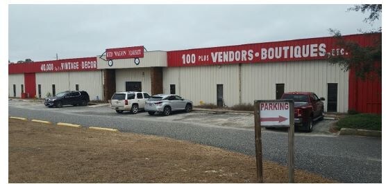

Property Detail
616 Nw Broad St
C40A-003
5.35 AC-2 COMM BLDGS-616 NW BROAD ST
Storebuilding
Toombs
COMMERCIAL
Georgia
B and X Area of moderate flood hazard, usually the area between the limits of the 100-year and 500-year floods.
5.35 AC
2025
Georgia South Area
2025
Other Market Areas
970202
Vidalia, GA
39,240 SF
NEARBY LISTINGS FOR SALE OR LEASE
-
-
View all Lyons listings for sale on LoopNet.com
DEMOGRAPHICS near 616 Nw Broad St
1 mile
3 mile
5 mile
2025 Total Population
1,137
6,277
16,552
2030 Population
1,156
6,388
16,884
Pop Growth 2025-2030
+ 1.67%
+ 1.77%
+ 2.01%
Average Age
42
39
40
2025 Total Households
445
2,481
6,545
HH Growth 2025-2030
+ 1.80%
+ 1.69%
+ 1.99%
Median Household Inc
$85,795
$55,357
$49,491
Avg Household Size
2.40
2.50
2.40
2025 Avg HH Vehicles
2.00
2.00
2.00
Median Home Value
$129,807
$112,743
$136,685
Median Year Built
1982
1978
1978
Nearby Places
Map Layers
Map Styles
 Street
 Aerial
Transit
 Traffic
 Biking
Places
Listings with unknown addresses are not visible on the map
- Restaurants
- Banks
- Shops
- Fitness
- Groceries
SALE & LEASE HISTORY
LISTING DATE
SALE/LEASE

Feb 06, 2018
For Sale
Nearby Properties
Address
Land Use
TOTAL SIZE
Lot Size
Zoning
Address
Land Use
TOTAL SIZE
Lot Size
Zoning
10,960 SF
1.03 AC
RESIDENTIA
Address
Land Use
TOTAL SIZE
Lot Size
Zoning
194,662 SF
20.17 AC
RESIDENTIA
Address
Land Use
TOTAL SIZE
Lot Size
Zoning
61,865 SF
6.56 AC
RESIDENTIA
Address
Land Use
TOTAL SIZE
Lot Size
Zoning
6,672 SF
4.82 AC
RESIDENTIA
Address
Land Use
TOTAL SIZE
Lot Size
Zoning
82,078 SF
45.80 AC
RESIDENTIA
Address
Land Use
TOTAL SIZE
Lot Size
Zoning
467,851 SF
48.13 AC
RESIDENTIA
Address
Land Use
TOTAL SIZE
Lot Size
Zoning
266,226 SF
27.02 AC
RESIDENTIA
Address
Land Use
TOTAL SIZE
Lot Size
Zoning
100,303 SF
102.82 AC
RESIDENTIA
Address
Land Use
TOTAL SIZE
Lot Size
Zoning
88,219 SF
80.25 AC
RESIDENTIA
Address
Land Use
TOTAL SIZE
Lot Size
Zoning
35,403 SF
13.25 AC
RESIDENTIA
Address
Land Use
TOTAL SIZE
Lot Size
Zoning
44,716 SF
8.83 AC
RESIDENTIA
Address
Land Use
TOTAL SIZE
Lot Size
Zoning
209,643 SF
22.05 AC
COMMERCIAL
Address
Land Use
TOTAL SIZE
Lot Size
Zoning
359,856 SF
18.72 AC
UNZONED RU
Address
Land Use
TOTAL SIZE
Lot Size
Zoning
58,006 SF
2.94 AC
RESIDENTIA
Address
Land Use
TOTAL SIZE
Lot Size
Zoning
100,932 SF
12.71 AC
RESIDENTIA
Address
Land Use
TOTAL SIZE
Lot Size
Zoning
18,078 SF
67.43 AC
COMMERCIAL
Address
Land Use
TOTAL SIZE
Lot Size
Zoning
50,668 SF
2.07 AC
RESIDENTIA
Address
Land Use
TOTAL SIZE
Lot Size
Zoning
108,953 SF
12.58 AC
COMMERCIAL
Address
Land Use
TOTAL SIZE
Lot Size
Zoning
135,715 SF
10.42 AC
COMMERCIAL
Address
Land Use
TOTAL SIZE
Lot Size
Zoning
119,047 SF
6 AC
COMMERCIAL
Address
Land Use
TOTAL SIZE
Lot Size
Zoning
15,340 SF
18.80 AC
RESIDENTIA
Address
Land Use
TOTAL SIZE
Lot Size
Zoning
44,352 SF
1.61 AC
COMMERCIAL
Address
Land Use
TOTAL SIZE
Lot Size
Zoning
37,293 SF
9.77 AC
COMMERCIAL
Address
Land Use
TOTAL SIZE
Lot Size
Zoning
60,000 SF
8.29 AC
COMMERCIAL
Address
Land Use
TOTAL SIZE
Lot Size
Zoning
30,054 SF
6.30 AC
COMMERCIAL
Address
Land Use
TOTAL SIZE
Lot Size
Zoning
31,416 SF
2.66 AC
RESIDENTIA
Address
Land Use
TOTAL SIZE
Lot Size
Zoning
51,337 SF
9.06 AC
COMMERCIAL
Address
Land Use
TOTAL SIZE
Lot Size
Zoning
18,249 SF
15.63 AC
RESIDENTIA
Address
Land Use
TOTAL SIZE
Lot Size
Zoning
30,320 SF
7.85 AC
RESIDENTIA
Address
Land Use
TOTAL SIZE
Lot Size
Zoning
5,343 SF
4.24 AC
RESIDENTIA
The World's #1 Commercial Real Estate Marketplace
Connect with us
© 2026 CoStar Group
The information above has been obtained from sources believed reliable. While we do not doubt its accuracy we have not verified it and make no guarantee, warranty or representation about it. It is your responsibility to independently confirm its accuracy and completeness. Any projections, opinions, assumptions, or estimates used are for example only and do not represent the current or future performance of the property. The value of this transaction to you depends on tax and other factors which should be evaluated by your tax, financial, and legal advisors. You and your advisors should conduct a careful, independent investigation of the property to determine to your satisfaction the suitability of the property for your needs.