Property Record
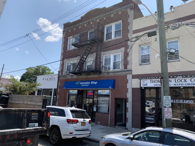
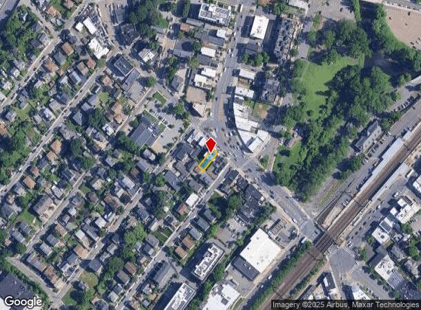
616 Old White Plains Rd, Mamaroneck, NY 10543
NEARBY LISTINGS FOR SALE OR LEASE
Property Detail
616 Old White Plains Rd
3203-008-000-00023-000-0572
Map Of The Village Washingtonville
Commercialofficeresidentialmixeduse
Westchester
AE
New York
36119C0353F
0.07 AC
2025
Larchmont/Mamaroneck
2024
Westchester/So Connecticut
007200
New York-Jersey City-White Plains, NY-NJ
5,502 SF
DEMOGRAPHICS near 616 Old White Plains Rd
1 Mile
3 Mile
5 Mile
2024 Total Population
18,342
84,587
266,733
2029 Population
17,743
82,673
261,666
Pop Growth 2024-2029
(3.27%)
(2.26%)
(1.90%)
Average Age
41
41
41
2024 Total Households
6,851
29,665
95,242
HH Growth 2024-2029
(3.33%)
(2.36%)
(1.91%)
Median Household Inc
$130,044
$176,417
$135,666
Avg Household Size
2.60
2.80
2.70
2024 Avg HH Vehicles
2.00
2.00
2.00
Median Home Value
$739,583
$915,488
$790,024
Median Year Built
1953
1954
1952
Nearby Places
- Restaurants
- Banks
- Shops
- Fitness
- Groceries
SALE & LEASE HISTORY
LISTING DATE
SALE/LEASE

Jan 24, 2020
For Sale
Nearby Properties
Address
Land Use
TOTAL SIZE
Lot Size
Zoning
Address
Land Use
TOTAL SIZE
Lot Size
Zoning
Address
Land Use
TOTAL SIZE
Lot Size
Zoning
413,946 SF
20.27 AC
Address
Land Use
TOTAL SIZE
Lot Size
Zoning
Address
Land Use
TOTAL SIZE
Lot Size
Zoning
Address
Land Use
TOTAL SIZE
Lot Size
Zoning
Address
Land Use
TOTAL SIZE
Lot Size
Zoning
125,010 SF
4.02 AC
Address
Land Use
TOTAL SIZE
Lot Size
Zoning
21.33 AC
Address
Land Use
TOTAL SIZE
Lot Size
Zoning
118,723 SF
3.45 AC
Address
Land Use
TOTAL SIZE
Lot Size
Zoning
82,895 SF
23.03 AC
A2
Address
Land Use
TOTAL SIZE
Lot Size
Zoning
188.31 AC
Address
Land Use
TOTAL SIZE
Lot Size
Zoning
67.51 AC
Address
Land Use
TOTAL SIZE
Lot Size
Zoning
1,056 SF
42.50 AC
PB
Address
Land Use
TOTAL SIZE
Lot Size
Zoning
5COMMUND
Address
Land Use
TOTAL SIZE
Lot Size
Zoning
5.57 AC
AA1
Address
Land Use
TOTAL SIZE
Lot Size
Zoning
48,499 SF
8.52 AC
A2/A3
Address
Land Use
TOTAL SIZE
Lot Size
Zoning
61,606 SF
19.99 AC
A4/A3
Address
Land Use
TOTAL SIZE
Lot Size
Zoning
11,951 SF
24.88 AC
Address
Land Use
TOTAL SIZE
Lot Size
Zoning
132,505 SF
5.53 AC
R6
Address
Land Use
TOTAL SIZE
Lot Size
Zoning
6.31 AC
R-5 SFR
Address
Land Use
TOTAL SIZE
Lot Size
Zoning
37,187 SF
2.62 AC
Address
Land Use
TOTAL SIZE
Lot Size
Zoning
Address
Land Use
TOTAL SIZE
Lot Size
Zoning
34,454 SF
216.47 AC
Address
Land Use
TOTAL SIZE
Lot Size
Zoning
99,502 SF
11.97 AC
Address
Land Use
TOTAL SIZE
Lot Size
Zoning
74,147 SF
2.76 AC
Address
Land Use
TOTAL SIZE
Lot Size
Zoning
48,240 SF
3.89 AC
Address
Land Use
TOTAL SIZE
Lot Size
Zoning
64,966 SF
4.92 AC
R20
Address
Land Use
TOTAL SIZE
Lot Size
Zoning
68,022 SF
4.31 AC
Address
Land Use
TOTAL SIZE
Lot Size
Zoning
76,258 SF
4.22 AC
R7.5
Address
Land Use
TOTAL SIZE
Lot Size
Zoning
92,960 SF
11.39 AC
Address
Land Use
TOTAL SIZE
Lot Size
Zoning
62,664 SF
3.50 AC
The World's #1 Commercial Real Estate Marketplace
Connect with us
© 2025 CoStar Group
The information above has been obtained from sources believed reliable. While we do not doubt its accuracy we have not verified it and make no guarantee, warranty or representation about it. It is your responsibility to independently confirm its accuracy and completeness. Any projections, opinions, assumptions, or estimates used are for example only and do not represent the current or future performance of the property. The value of this transaction to you depends on tax and other factors which should be evaluated by your tax, financial, and legal advisors. You and your advisors should conduct a careful, independent investigation of the property to determine to your satisfaction the suitability of the property for your needs.