Property Record
6160 E Sam Houston Pkwy N, Houston, TX 77049
NEARBY LISTINGS FOR SALE OR LEASE
Property Detail
6160 E Sam Houston Pkwy N
1258950010001
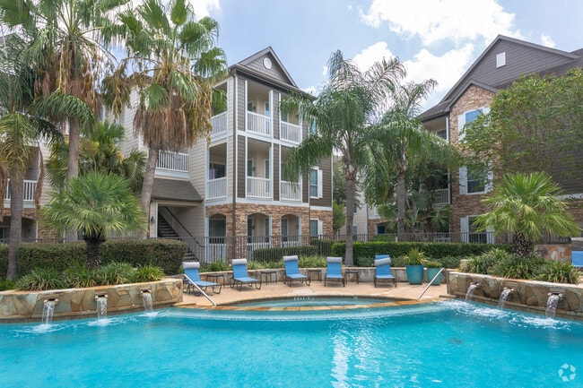
Stone Park Apts
Apartment
RESERVE BLK 1 (BLDGS 1 THRU 16) STONE PARK APTS
X
Harris
48201C0710M
Texas
2024
8.29 AC
2025
North Shore
252201
Houston
197,953 SF
Houston-The Woodlands-Sugar Land, TX
DEMOGRAPHICS near 6160 E Sam Houston Pkwy N
1 Mile
3 Mile
5 Mile
2024 Total Population
12,685
102,800
167,211
2029 Population
12,762
104,463
170,369
Pop Growth 2024-2029
+ 0.61%
+ 1.62%
+ 1.89%
Average Age
35
34
33
2024 Total Households
3,954
31,294
50,727
HH Growth 2024-2029
+ 0.53%
+ 1.53%
+ 1.82%
Median Household Inc
$75,904
$57,908
$54,741
Avg Household Size
3.10
3.20
3.20
2024 Avg HH Vehicles
2.00
2.00
2.00
Median Home Value
$207,335
$158,266
$153,570
Median Year Built
2002
1986
1986
Nearby Places
Map Layers
Map Styles
 Street
 Aerial
- Restaurants
- Banks
- Shops
- Fitness
- Groceries
PUBLIC TRANSPORTATION
AIRPORT
George Bush Intcntl/Houston
DRIVE
WALK
Distance
George Bush Intcntl/Houston
25 min
19.7 mi
William P Hobby
DRIVE
WALK
Distance
William P Hobby
35 min
20.2 mi
Freight Ports
Port of Houston
DRIVE
WALK
Distance
Port of Houston
21 min
12.2 mi
Nearby Properties
Address
Land Use
TOTAL SIZE
Lot Size
Zoning
Address
Land Use
TOTAL SIZE
Lot Size
Zoning
Address
Land Use
TOTAL SIZE
Lot Size
Zoning
409.44 AC
Address
Land Use
TOTAL SIZE
Lot Size
Zoning
1,056.36 AC
Address
Land Use
TOTAL SIZE
Lot Size
Zoning
183.58 AC
Address
Land Use
TOTAL SIZE
Lot Size
Zoning
36.04 AC
Address
Land Use
TOTAL SIZE
Lot Size
Zoning
1,403,952 SF
48.81 AC
Address
Land Use
TOTAL SIZE
Lot Size
Zoning
337,331 SF
56.09 AC
Address
Land Use
TOTAL SIZE
Lot Size
Zoning
699,448 SF
46.40 AC
Address
Land Use
TOTAL SIZE
Lot Size
Zoning
760,851 SF
41.87 AC
Address
Land Use
TOTAL SIZE
Lot Size
Zoning
671,363 SF
61.27 AC
Address
Land Use
TOTAL SIZE
Lot Size
Zoning
331,284 SF
15.15 AC
Address
Land Use
TOTAL SIZE
Lot Size
Zoning
277,486 SF
15.42 AC
Address
Land Use
TOTAL SIZE
Lot Size
Zoning
271,428 SF
10.57 AC
Address
Land Use
TOTAL SIZE
Lot Size
Zoning
225,124 SF
10.20 AC
Address
Land Use
TOTAL SIZE
Lot Size
Zoning
202,544 SF
4.06 AC
Address
Land Use
TOTAL SIZE
Lot Size
Zoning
485,662 SF
48.80 AC
Address
Land Use
TOTAL SIZE
Lot Size
Zoning
248,293 SF
13.20 AC
Address
Land Use
TOTAL SIZE
Lot Size
Zoning
212,558 SF
52.87 AC
Address
Land Use
TOTAL SIZE
Lot Size
Zoning
526,975 SF
21.08 AC
Address
Land Use
TOTAL SIZE
Lot Size
Zoning
168,348 SF
108.41 AC
Address
Land Use
TOTAL SIZE
Lot Size
Zoning
227,679 SF
13.31 AC
Address
Land Use
TOTAL SIZE
Lot Size
Zoning
110,900 SF
18.01 AC
Address
Land Use
TOTAL SIZE
Lot Size
Zoning
330,927 SF
82.08 AC
Address
Land Use
TOTAL SIZE
Lot Size
Zoning
208,648 SF
8.99 AC
Address
Land Use
TOTAL SIZE
Lot Size
Zoning
392.95 AC
Address
Land Use
TOTAL SIZE
Lot Size
Zoning
537,768 SF
12.46 AC
Address
Land Use
TOTAL SIZE
Lot Size
Zoning
377,109 SF
17.36 AC
Address
Land Use
TOTAL SIZE
Lot Size
Zoning
48.81 AC
Address
Land Use
TOTAL SIZE
Lot Size
Zoning
246,277 SF
10.91 AC
The World's #1 Commercial Real Estate Marketplace
Connect with us
© 2026 CoStar Group
The information above has been obtained from sources believed reliable. While we do not doubt its accuracy we have not verified it and make no guarantee, warranty or representation about it. It is your responsibility to independently confirm its accuracy and completeness. Any projections, opinions, assumptions, or estimates used are for example only and do not represent the current or future performance of the property. The value of this transaction to you depends on tax and other factors which should be evaluated by your tax, financial, and legal advisors. You and your advisors should conduct a careful, independent investigation of the property to determine to your satisfaction the suitability of the property for your needs.