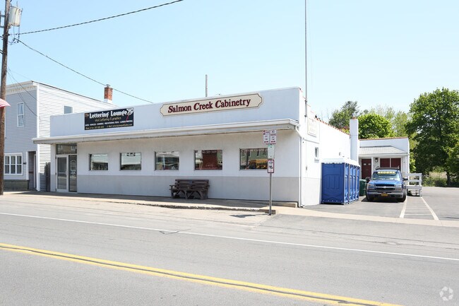
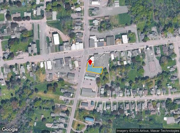
Property Record
6160 State Route 21, Williamson, NY 14589
NEARBY LISTINGS FOR SALE OR LEASE
-
-
View all Williamson listings for lease on LoopNet.com
Property Detail
6160 State Route 21
Rochester, NY
33117-12-929508
544600-065-117-0012-959-512-0000
Wayne
Commercialofficeresidentialmixeduse
New York
2025
959.512
2024
0.21 AC
020402
Wayne County
3,286 SF
Rochester
DEMOGRAPHICS near 6160 State Route 21
1 Mile
3 Mile
5 Mile
2024 Total Population
2,174
5,078
12,493
2029 Population
2,125
4,985
12,378
Pop Growth 2024-2029
(2.25%)
(1.83%)
(0.92%)
Average Age
42
43
43
2024 Total Households
928
2,115
5,107
HH Growth 2024-2029
(2.37%)
(1.94%)
(0.98%)
Median Household Inc
$67,177
$69,420
$69,107
Avg Household Size
2.30
2.40
2.40
2024 Avg HH Vehicles
2.00
2.00
2.00
Median Home Value
$137,123
$150,201
$157,238
Median Year Built
1960
1962
1966
Nearby Places
- Restaurants
- Banks
- Shops
- Fitness
- Groceries
PUBLIC TRANSPORTATION
AIRPORT
Frederick Douglass/Greater Rochester International
DRIVE
WALK
Distance
Frederick Douglass/Greater Rochester International
43 min
29.7 mi
Freight Ports
Albany, NY Port
DRIVE
WALK
Distance
Albany, NY Port
248 min
202.7 mi
SALE & LEASE HISTORY
LISTING DATE
SALE/LEASE

Sep 25, 2016
For Lease
Aug 28, 2018
For Lease
Nearby Properties
Address
Land Use
TOTAL SIZE
Lot Size
Zoning
Address
Land Use
TOTAL SIZE
Lot Size
Zoning
65,762 SF
51.16 AC
I1
Address
Land Use
TOTAL SIZE
Lot Size
Zoning
952 SF
91.60 AC
MU1
Address
Land Use
TOTAL SIZE
Lot Size
Zoning
201.60 AC
I1
Address
Land Use
TOTAL SIZE
Lot Size
Zoning
12.25 AC
R1
Address
Land Use
TOTAL SIZE
Lot Size
Zoning
97,515 SF
38.19 AC
R1
Address
Land Use
TOTAL SIZE
Lot Size
Zoning
11,482 SF
7.69 AC
C1
Address
Land Use
TOTAL SIZE
Lot Size
Zoning
19.15 AC
R1
Address
Land Use
TOTAL SIZE
Lot Size
Zoning
14,690 SF
2.36 AC
C1
Address
Land Use
TOTAL SIZE
Lot Size
Zoning
25,700 SF
13.55 AC
MU1
Address
Land Use
TOTAL SIZE
Lot Size
Zoning
Address
Land Use
TOTAL SIZE
Lot Size
Zoning
160,000 SF
15.72 AC
I1
Address
Land Use
TOTAL SIZE
Lot Size
Zoning
19,000 SF
8.60 AC
C1
Address
Land Use
TOTAL SIZE
Lot Size
Zoning
Address
Land Use
TOTAL SIZE
Lot Size
Zoning
1,152 SF
15.60 AC
C2
Address
Land Use
TOTAL SIZE
Lot Size
Zoning
9.60 AC
Address
Land Use
TOTAL SIZE
Lot Size
Zoning
12.58 AC
C1
Address
Land Use
TOTAL SIZE
Lot Size
Zoning
1.94 AC
MU1
Address
Land Use
TOTAL SIZE
Lot Size
Zoning
13,263 SF
3.81 AC
C2
Address
Land Use
TOTAL SIZE
Lot Size
Zoning
19,020 SF
3.43 AC
MU1
Address
Land Use
TOTAL SIZE
Lot Size
Zoning
16,420 SF
6.75 AC
C1
Address
Land Use
TOTAL SIZE
Lot Size
Zoning
6,064 SF
0.46 AC
C1
Address
Land Use
TOTAL SIZE
Lot Size
Zoning
27.03 AC
I1
Address
Land Use
TOTAL SIZE
Lot Size
Zoning
13,400 SF
4.20 AC
C2
Address
Land Use
TOTAL SIZE
Lot Size
Zoning
14,063 SF
3.24 AC
C1
Address
Land Use
TOTAL SIZE
Lot Size
Zoning
1.52 AC
R1
Address
Land Use
TOTAL SIZE
Lot Size
Zoning
3,544 SF
14.53 AC
MU1
Address
Land Use
TOTAL SIZE
Lot Size
Zoning
30,420 SF
4.02 AC
C1
Address
Land Use
TOTAL SIZE
Lot Size
Zoning
37.98 AC
A1
Address
Land Use
TOTAL SIZE
Lot Size
Zoning
12,320 SF
36.88 AC
C2
Address
Land Use
TOTAL SIZE
Lot Size
Zoning
5,556 SF
4.28 AC
C1
The World's #1 Commercial Real Estate Marketplace
Connect with us
© 2025 CoStar Group
The information above has been obtained from sources believed reliable. While we do not doubt its accuracy we have not verified it and make no guarantee, warranty or representation about it. It is your responsibility to independently confirm its accuracy and completeness. Any projections, opinions, assumptions, or estimates used are for example only and do not represent the current or future performance of the property. The value of this transaction to you depends on tax and other factors which should be evaluated by your tax, financial, and legal advisors. You and your advisors should conduct a careful, independent investigation of the property to determine to your satisfaction the suitability of the property for your needs.