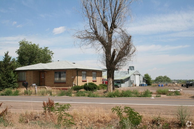
Property Record
6161 E 88Th Ave, Henderson, CO 80640


Save to a Folder
{{folder.Name}}
{{folder.ListingIds.length}} Properties
{{folder.ListingIds.length}} Property
Create a New Folder
Property Detail
6161 E 88Th Ave
1721-20-0-00-042
SECT,TWN,RNG:20-2-67 DESC: PARC IN THE SW COR OF THE SE4 SW4 OF SEC 20 DESC AS FOLS BEG AT THE SW COR OF THE SE4 SW4 OF SEC 20 TH S 89D 57M 30S E ALG THE S LN OF SD SW4 OF SEC 20 A DIST OF 401 FT TO THE TRUE POB TH N 00D 05M 29S E 323/75 FT TH S 89D
Warehouse
Adams
C5
Colorado
B and X Area of moderate flood hazard, usually the area between the limits of the 100-year and 500-year floods.
1.98 AC
2024
North Denver
2025
Denver
008802
Denver-Aurora-Centennial, CO
11,385 SF
NEARBY LISTINGS FOR SALE OR LEASE
DEMOGRAPHICS near 6161 E 88Th Ave
1 mile
3 mile
5 mile
2025 Total Population
2,209
69,621
210,817
2030 Population
2,251
71,832
218,464
Pop Growth 2025-2030
+ 1.90%
+ 3.18%
+ 3.63%
Average Age
34
36
36
2025 Total Households
596
22,456
71,345
HH Growth 2025-2030
+ 2.01%
+ 3.46%
+ 3.91%
Median Household Inc
$70,995
$86,721
$90,037
Avg Household Size
3.40
3.00
2.90
2025 Avg HH Vehicles
3.00
2.00
2.00
Median Home Value
$84,334
$411,056
$448,924
Median Year Built
1989
1980
1986
Nearby Places
Map Layers
Map Styles
 Street
 Aerial
Layers
 Traffic
 Biking
Places
Listings with unknown addresses are not visible on the map
- Restaurants
- Banks
- Shops
- Fitness
- Groceries
PUBLIC TRANSPORTATION
COMMUTER RAIL
Original Thornton - 88Th Station Track 1 (Union Station to Eastlake & 124th Station - Regional Transportation District)
Drive
Walk
Distance
Original Thornton - 88Th Station Track 1 (Union Station to Eastlake & 124th Station - Regional Transportation District)
5 min
2.2 mi
Thornton Crossroads - 104Th Station Track 1 (Union Station to Eastlake & 124th Station - Regional Transportation District)
Drive
Walk
Distance
Thornton Crossroads - 104Th Station Track 1 (Union Station to Eastlake & 124th Station - Regional Transportation District)
6 min
3.3 mi
AIRPORT
Denver International
Drive
Walk
Distance
Denver International
28 min
21.1 mi
Freight Ports
Tulsa Port Of Catoosa
Drive
Walk
Distance
Tulsa Port Of Catoosa
729 min
710.2 mi
SALE & LEASE HISTORY
LISTING DATE
SALE/LEASE

Jan 18, 2022
For Sale
Nearby Properties
Address
Land Use
TOTAL SIZE
Lot Size
Zoning
Address
Land Use
TOTAL SIZE
Lot Size
Zoning
295,558 SF
13.41 AC
Address
Land Use
TOTAL SIZE
Lot Size
Zoning
106,680 SF
17.39 AC
Address
Land Use
TOTAL SIZE
Lot Size
Zoning
140,328 SF
6.54 AC
PUD
Address
Land Use
TOTAL SIZE
Lot Size
Zoning
17,063 SF
2.01 AC
Address
Land Use
TOTAL SIZE
Lot Size
Zoning
649,540 SF
33.65 AC
Address
Land Use
TOTAL SIZE
Lot Size
Zoning
74,106 SF
3.95 AC
PUD
Address
Land Use
TOTAL SIZE
Lot Size
Zoning
296,000 SF
52.44 AC
A3
Address
Land Use
TOTAL SIZE
Lot Size
Zoning
549,866 SF
33.82 AC
Address
Land Use
TOTAL SIZE
Lot Size
Zoning
91,326 SF
5.09 AC
Address
Land Use
TOTAL SIZE
Lot Size
Zoning
94,213 SF
3.84 AC
A1
Address
Land Use
TOTAL SIZE
Lot Size
Zoning
85,738 SF
4.43 AC
Address
Land Use
TOTAL SIZE
Lot Size
Zoning
282,144 SF
4.01 AC
Address
Land Use
TOTAL SIZE
Lot Size
Zoning
616.10 AC
A3
Address
Land Use
TOTAL SIZE
Lot Size
Zoning
328,674 SF
47.13 AC
Address
Land Use
TOTAL SIZE
Lot Size
Zoning
329,940 SF
10.31 AC
Address
Land Use
TOTAL SIZE
Lot Size
Zoning
11,200 SF
36.45 AC
A1
Address
Land Use
TOTAL SIZE
Lot Size
Zoning
250,523 SF
70.73 AC
I1
Address
Land Use
TOTAL SIZE
Lot Size
Zoning
109,372 SF
13.18 AC
Address
Land Use
TOTAL SIZE
Lot Size
Zoning
172,816 SF
59.89 AC
Address
Land Use
TOTAL SIZE
Lot Size
Zoning
459,283 SF
16.88 AC
Address
Land Use
TOTAL SIZE
Lot Size
Zoning
258,279 SF
70.11 AC
I2
Address
Land Use
TOTAL SIZE
Lot Size
Zoning
219,959 SF
10 AC
Address
Land Use
TOTAL SIZE
Lot Size
Zoning
208,864 SF
19.26 AC
Address
Land Use
TOTAL SIZE
Lot Size
Zoning
312,218 SF
31.14 AC
Address
Land Use
TOTAL SIZE
Lot Size
Zoning
2,240 SF
128.54 AC
A1
Address
Land Use
TOTAL SIZE
Lot Size
Zoning
373,767 SF
18.87 AC
Address
Land Use
TOTAL SIZE
Lot Size
Zoning
199,500 SF
15.03 AC
Address
Land Use
TOTAL SIZE
Lot Size
Zoning
204,000 SF
9.96 AC
Address
Land Use
TOTAL SIZE
Lot Size
Zoning
71,966 SF
11.65 AC
R1C
Address
Land Use
TOTAL SIZE
Lot Size
Zoning
119,680 SF
10.10 AC
C5
The World's #1 Commercial Real Estate Marketplace
Connect with us
© 2026 CoStar Group
The information above has been obtained from sources believed reliable. While we do not doubt its accuracy we have not verified it and make no guarantee, warranty or representation about it. It is your responsibility to independently confirm its accuracy and completeness. Any projections, opinions, assumptions, or estimates used are for example only and do not represent the current or future performance of the property. The value of this transaction to you depends on tax and other factors which should be evaluated by your tax, financial, and legal advisors. You and your advisors should conduct a careful, independent investigation of the property to determine to your satisfaction the suitability of the property for your needs.