Property Record
6161 Us Route 127 N, Eaton, OH 45320

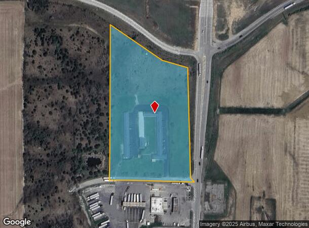
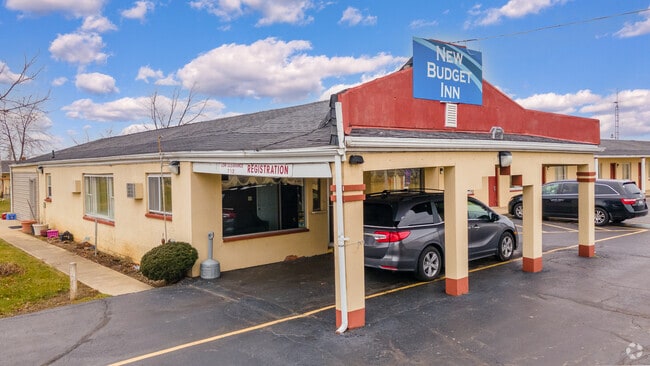
This Property Is For Sale
NEARBY LISTINGS FOR SALE OR LEASE
-
-
View all Eaton listings for sale on LoopNet.com
Property Detail
6161 Us Route 127 N
Officebuilding
CENT PT SW
X
Preble
39135C0135E
Ohio
2024
7.36 AC
2024
Ohio South Area
410100
Cincinnati/Dayton
1,248 SF
I27-9235-3-0-00-000-2000
DEMOGRAPHICS near 6161 Us Route 127 N
1 Mile
3 Mile
5 Mile
2024 Total Population
43
877
6,398
2029 Population
42
864
6,326
Pop Growth 2024-2029
(2.33%)
(1.48%)
(1.13%)
Average Age
42
43
44
2024 Total Households
17
357
2,684
HH Growth 2024-2029
0.00%
(1.40%)
(1.12%)
Median Household Inc
$58,333
$62,738
$61,303
Avg Household Size
2.40
2.50
2.30
2024 Avg HH Vehicles
2.00
2.00
2.00
Median Home Value
$150,000
$165,765
$157,805
Median Year Built
1949
1956
1969
Nearby Places
Map Layers
Map Styles
 Street
 Aerial
- Restaurants
- Banks
- Shops
- Fitness
- Groceries
PUBLIC TRANSPORTATION
AIRPORT
James M Cox Dayton International
DRIVE
WALK
Distance
James M Cox Dayton International
33 min
26.1 mi
Freight Ports
Port of Toledo
DRIVE
WALK
Distance
Port of Toledo
196 min
169.8 mi
Nearby Properties
Address
Land Use
TOTAL SIZE
Lot Size
Zoning
Address
Land Use
TOTAL SIZE
Lot Size
Zoning
2,228 SF
89.79 AC
Address
Land Use
TOTAL SIZE
Lot Size
Zoning
8,000 SF
5.57 AC
Address
Land Use
TOTAL SIZE
Lot Size
Zoning
Address
Land Use
TOTAL SIZE
Lot Size
Zoning
Address
Land Use
TOTAL SIZE
Lot Size
Zoning
128.50 AC
Address
Land Use
TOTAL SIZE
Lot Size
Zoning
119.95 AC
Address
Land Use
TOTAL SIZE
Lot Size
Zoning
119.56 AC
Address
Land Use
TOTAL SIZE
Lot Size
Zoning
115.83 AC
Address
Land Use
TOTAL SIZE
Lot Size
Zoning
121.83 AC
Address
Land Use
TOTAL SIZE
Lot Size
Zoning
105.63 AC
Address
Land Use
TOTAL SIZE
Lot Size
Zoning
Address
Land Use
TOTAL SIZE
Lot Size
Zoning
115.94 AC
Address
Land Use
TOTAL SIZE
Lot Size
Zoning
103.50 AC
Address
Land Use
TOTAL SIZE
Lot Size
Zoning
103.94 AC
Address
Land Use
TOTAL SIZE
Lot Size
Zoning
2,704 SF
74.02 AC
Address
Land Use
TOTAL SIZE
Lot Size
Zoning
6,720 SF
5.06 AC
Address
Land Use
TOTAL SIZE
Lot Size
Zoning
109.62 AC
Address
Land Use
TOTAL SIZE
Lot Size
Zoning
100.68 AC
Address
Land Use
TOTAL SIZE
Lot Size
Zoning
92.98 AC
Address
Land Use
TOTAL SIZE
Lot Size
Zoning
5,800 SF
4 AC
Address
Land Use
TOTAL SIZE
Lot Size
Zoning
85.63 AC
Address
Land Use
TOTAL SIZE
Lot Size
Zoning
Address
Land Use
TOTAL SIZE
Lot Size
Zoning
91.50 AC
Address
Land Use
TOTAL SIZE
Lot Size
Zoning
80.78 AC
Address
Land Use
TOTAL SIZE
Lot Size
Zoning
101.37 AC
Address
Land Use
TOTAL SIZE
Lot Size
Zoning
77.64 AC
Address
Land Use
TOTAL SIZE
Lot Size
Zoning
75.33 AC
Address
Land Use
TOTAL SIZE
Lot Size
Zoning
81.73 AC
Address
Land Use
TOTAL SIZE
Lot Size
Zoning
2,784 SF
43.58 AC
The World's #1 Commercial Real Estate Marketplace
Connect with us
© 2026 CoStar Group
The information above has been obtained from sources believed reliable. While we do not doubt its accuracy we have not verified it and make no guarantee, warranty or representation about it. It is your responsibility to independently confirm its accuracy and completeness. Any projections, opinions, assumptions, or estimates used are for example only and do not represent the current or future performance of the property. The value of this transaction to you depends on tax and other factors which should be evaluated by your tax, financial, and legal advisors. You and your advisors should conduct a careful, independent investigation of the property to determine to your satisfaction the suitability of the property for your needs.