Property Record
6170 Idlewild St, Fort Myers, FL 33966
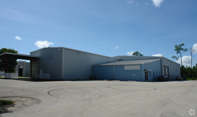


This Property Is For Sale
NEARBY LISTINGS FOR SALE OR LEASE
Property Detail
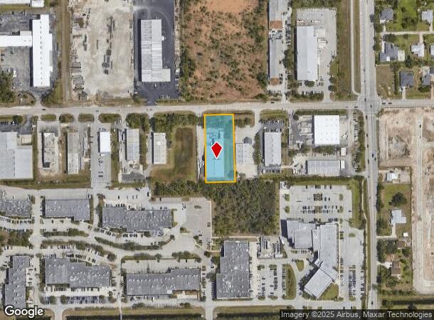
6170 Idlewild St
Cape Coral-Fort Myers, FL
Metro Parkway Corridor
07-45-25-00-00002.0060
BEG NE COR OF NW 1/4 TH W 698.95 FT TO POB TH W 144 FT OR 2436/548
Warehouse
Lee
AH
Florida
12071C0428H
6
2024
1.09 AC
2025
S Ft Myers/San Carlos
001207
Southwest Florida
16,846 SF
DEMOGRAPHICS near 6170 Idlewild St
1 Mile
3 Mile
5 Mile
2024 Total Population
4,240
73,423
155,810
2029 Population
5,214
87,165
185,314
Pop Growth 2024-2029
+ 22.97%
+ 18.72%
+ 18.94%
Average Age
43
42
46
2024 Total Households
1,547
32,357
69,822
HH Growth 2024-2029
+ 22.69%
+ 18.34%
+ 18.72%
Median Household Inc
$83,211
$57,769
$59,870
Avg Household Size
2.60
2.20
2.10
2024 Avg HH Vehicles
2.00
1.00
1.00
Median Home Value
$302,313
$271,301
$285,690
Median Year Built
2004
1991
1992
Nearby Places
- Restaurants
- Banks
- Shops
- Fitness
- Groceries
PUBLIC TRANSPORTATION
AIRPORT
Southwest Florida International
DRIVE
WALK
Distance
Southwest Florida International
19 min
9.8 mi
Punta Gorda
DRIVE
WALK
Distance
Punta Gorda
40 min
30.9 mi
Nearby Properties
Address
Land Use
TOTAL SIZE
Lot Size
Zoning
Address
Land Use
TOTAL SIZE
Lot Size
Zoning
741,488 SF
23.22 AC
CPD
Address
Land Use
TOTAL SIZE
Lot Size
Zoning
1,001,577 SF
140.54 AC
AG-2
Address
Land Use
TOTAL SIZE
Lot Size
Zoning
990,859 SF
38 AC
CI
Address
Land Use
TOTAL SIZE
Lot Size
Zoning
608,522 SF
38.57 AC
CG
Address
Land Use
TOTAL SIZE
Lot Size
Zoning
541,926 SF
54.06 AC
RM2
Address
Land Use
TOTAL SIZE
Lot Size
Zoning
520,572 SF
24.13 AC
CG
Address
Land Use
TOTAL SIZE
Lot Size
Zoning
689,351 SF
42.34 AC
RM-16/
Address
Land Use
TOTAL SIZE
Lot Size
Zoning
425,522 SF
380.73 AC
IL
Address
Land Use
TOTAL SIZE
Lot Size
Zoning
429,703 SF
16.24 AC
PUD
Address
Land Use
TOTAL SIZE
Lot Size
Zoning
331,738 SF
39.51 AC
RM-10
Address
Land Use
TOTAL SIZE
Lot Size
Zoning
445,073 SF
44.82 AC
C-1
Address
Land Use
TOTAL SIZE
Lot Size
Zoning
422,099 SF
1.10 AC
CG
Address
Land Use
TOTAL SIZE
Lot Size
Zoning
16.13 AC
Address
Land Use
TOTAL SIZE
Lot Size
Zoning
427,764 SF
12.73 AC
C1
Address
Land Use
TOTAL SIZE
Lot Size
Zoning
425,658 SF
25.61 AC
CG
Address
Land Use
TOTAL SIZE
Lot Size
Zoning
25.16 AC
RPD
Address
Land Use
TOTAL SIZE
Lot Size
Zoning
749,922 SF
41.78 AC
C1
Address
Land Use
TOTAL SIZE
Lot Size
Zoning
304,258 SF
12.20 AC
CG
Address
Land Use
TOTAL SIZE
Lot Size
Zoning
368,722 SF
18.09 AC
CG
Address
Land Use
TOTAL SIZE
Lot Size
Zoning
305,224 SF
17.11 AC
CG
Address
Land Use
TOTAL SIZE
Lot Size
Zoning
694,188 SF
22.43 AC
PUD
Address
Land Use
TOTAL SIZE
Lot Size
Zoning
364,206 SF
106.76 AC
PUD
Address
Land Use
TOTAL SIZE
Lot Size
Zoning
347,746 SF
29.74 AC
RM-10
Address
Land Use
TOTAL SIZE
Lot Size
Zoning
444,774 SF
36.07 AC
MPD
Address
Land Use
TOTAL SIZE
Lot Size
Zoning
284,371 SF
12.61 AC
CG
Address
Land Use
TOTAL SIZE
Lot Size
Zoning
349,074 SF
39.54 AC
MPD
Address
Land Use
TOTAL SIZE
Lot Size
Zoning
261,340 SF
9.07 AC
CG
Address
Land Use
TOTAL SIZE
Lot Size
Zoning
313,327 SF
29.72 AC
C-1
Address
Land Use
TOTAL SIZE
Lot Size
Zoning
281,781 SF
12.60 AC
C1
Address
Land Use
TOTAL SIZE
Lot Size
Zoning
13.71 AC
The World's #1 Commercial Real Estate Marketplace
Connect with us
© 2025 CoStar Group
The information above has been obtained from sources believed reliable. While we do not doubt its accuracy we have not verified it and make no guarantee, warranty or representation about it. It is your responsibility to independently confirm its accuracy and completeness. Any projections, opinions, assumptions, or estimates used are for example only and do not represent the current or future performance of the property. The value of this transaction to you depends on tax and other factors which should be evaluated by your tax, financial, and legal advisors. You and your advisors should conduct a careful, independent investigation of the property to determine to your satisfaction the suitability of the property for your needs.