Property Record
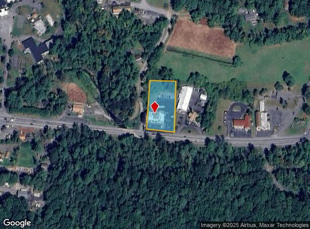
6172 Paradise Valley Rd, Cresco, PA 18326
NEARBY LISTINGS FOR SALE OR LEASE
Property Detail
6172 Paradise Valley Rd
11.5.1.50-15
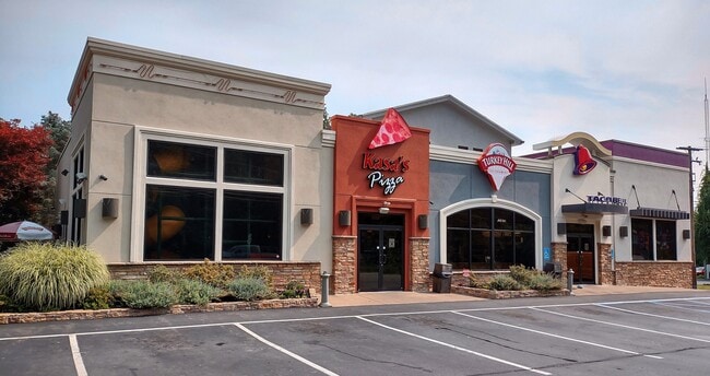
Taco Bell
Restaurantbuilding
Monroe
AE
Pennsylvania
42089C0118E
1.25 AC
2025
Monroe County
2025
Philadelphia
300201
East Stroudsburg, PA
5,570 SF
DEMOGRAPHICS near 6172 Paradise Valley Rd
1 Mile
3 Mile
5 Mile
2024 Total Population
557
7,039
22,742
2029 Population
542
6,985
22,766
Pop Growth 2024-2029
(2.69%)
(0.77%)
+ 0.11%
Average Age
45
43
43
2024 Total Households
220
2,753
8,790
HH Growth 2024-2029
(2.73%)
(0.62%)
+ 0.22%
Median Household Inc
$79,773
$73,694
$72,863
Avg Household Size
2.50
2.50
2.50
2024 Avg HH Vehicles
3.00
2.00
2.00
Median Home Value
$223,077
$189,803
$190,567
Median Year Built
1986
1985
1985
Nearby Places
Map Layers
Map Styles
 Street
 Aerial
- Restaurants
- Banks
- Shops
- Fitness
- Groceries
PUBLIC TRANSPORTATION
AIRPORT
Wilkes-Barre/Scranton International
DRIVE
WALK
Distance
Wilkes-Barre/Scranton International
52 min
38.8 mi
Freight Ports
Maher Terminal
DRIVE
WALK
Distance
Maher Terminal
110 min
81.7 mi
SALE & LEASE HISTORY
LISTING DATE
SALE/LEASE

Mar 01, 2022
For Sale
Feb 22, 2022
For Sale
Nearby Properties
Address
Land Use
TOTAL SIZE
Lot Size
Zoning
Address
Land Use
TOTAL SIZE
Lot Size
Zoning
1,132 SF
212.87 AC
I
Address
Land Use
TOTAL SIZE
Lot Size
Zoning
627,114 SF
896.17 AC
R-2
Address
Land Use
TOTAL SIZE
Lot Size
Zoning
11,060 SF
156.57 AC
R-2
Address
Land Use
TOTAL SIZE
Lot Size
Zoning
1,177,560 SF
77.25 AC
C-2
Address
Land Use
TOTAL SIZE
Lot Size
Zoning
133,288 SF
43.10 AC
R-2
Address
Land Use
TOTAL SIZE
Lot Size
Zoning
40,320 SF
17.79 AC
C
Address
Land Use
TOTAL SIZE
Lot Size
Zoning
64,756 SF
27.30 AC
R-1
Address
Land Use
TOTAL SIZE
Lot Size
Zoning
86,290 SF
6.15 AC
C-2
Address
Land Use
TOTAL SIZE
Lot Size
Zoning
612 SF
3,166 AC
C
Address
Land Use
TOTAL SIZE
Lot Size
Zoning
6,710 SF
5.18 AC
C-2
Address
Land Use
TOTAL SIZE
Lot Size
Zoning
3,400 SF
10.48 AC
C-1
Address
Land Use
TOTAL SIZE
Lot Size
Zoning
37,948 SF
47.53 AC
RR
Address
Land Use
TOTAL SIZE
Lot Size
Zoning
4,696 SF
130.12 AC
B-1
Address
Land Use
TOTAL SIZE
Lot Size
Zoning
1,212 SF
1 AC
C
Address
Land Use
TOTAL SIZE
Lot Size
Zoning
238.65 AC
R-3
Address
Land Use
TOTAL SIZE
Lot Size
Zoning
2,580 SF
437 AC
RR
Address
Land Use
TOTAL SIZE
Lot Size
Zoning
17,217 SF
6.67 AC
R-1
Address
Land Use
TOTAL SIZE
Lot Size
Zoning
26,603 SF
1.53 AC
C-2
Address
Land Use
TOTAL SIZE
Lot Size
Zoning
9,280 SF
0.34 AC
C-2
Address
Land Use
TOTAL SIZE
Lot Size
Zoning
14,502 SF
2.03 AC
C-2
Address
Land Use
TOTAL SIZE
Lot Size
Zoning
18,100 SF
2.72 AC
I
Address
Land Use
TOTAL SIZE
Lot Size
Zoning
2,732 SF
7.86 AC
C-2
Address
Land Use
TOTAL SIZE
Lot Size
Zoning
30,447 SF
111.66 AC
R-1
Address
Land Use
TOTAL SIZE
Lot Size
Zoning
427 AC
RR
Address
Land Use
TOTAL SIZE
Lot Size
Zoning
20,095 SF
1.76 AC
C-2
Address
Land Use
TOTAL SIZE
Lot Size
Zoning
4,732 SF
1.71 AC
C
Address
Land Use
TOTAL SIZE
Lot Size
Zoning
15,476 SF
1.36 AC
MU-V
Address
Land Use
TOTAL SIZE
Lot Size
Zoning
5,739 SF
1.57 AC
C-2
Address
Land Use
TOTAL SIZE
Lot Size
Zoning
6,644 SF
28.49 AC
MU-V
Address
Land Use
TOTAL SIZE
Lot Size
Zoning
2,736 SF
1.04 AC
C-2
The World's #1 Commercial Real Estate Marketplace
Connect with us
© 2025 CoStar Group
The information above has been obtained from sources believed reliable. While we do not doubt its accuracy we have not verified it and make no guarantee, warranty or representation about it. It is your responsibility to independently confirm its accuracy and completeness. Any projections, opinions, assumptions, or estimates used are for example only and do not represent the current or future performance of the property. The value of this transaction to you depends on tax and other factors which should be evaluated by your tax, financial, and legal advisors. You and your advisors should conduct a careful, independent investigation of the property to determine to your satisfaction the suitability of the property for your needs.