Property Record
6316 State Route 128 Rd, Miamitown, OH 45041


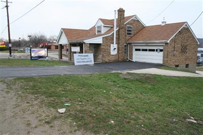
Property Detail
6316 State Route 128 Rd
630-0020-0035
HAMILTON-CLEVES RD 1.004 AC R2-T1-S6 SW R1-T1-S1 SE
Officebuilding
HAMILTON
AE The base floodplain where base flood elevations are provided. AE Zones are now used on new format FIRMs instead of A1-A30 Zones.
Ohio
2025
1 AC
2025
Forest Park/West
026002
Cincinnati/Dayton
3,158 SF
Cincinnati, OH-KY-IN
NEARBY LISTINGS FOR SALE OR LEASE
DEMOGRAPHICS near 6316 State Route 128 Rd
1 mile
3 mile
5 mile
2025 Total Population
1,640
20,540
57,342
2030 Population
1,637
20,655
57,523
Pop Growth 2025-2030
(0.18%)
+ 0.56%
+ 0.32%
Average Age
38
40
42
2025 Total Households
666
8,108
22,164
HH Growth 2025-2030
(0.30%)
+ 0.48%
+ 0.26%
Median Household Inc
$82,584
$85,348
$94,446
Avg Household Size
2.50
2.50
2.50
2025 Avg HH Vehicles
2.00
2.00
2.00
Median Home Value
$337,288
$306,684
$294,711
Median Year Built
1980
1990
1984
Nearby Places
Map Layers
Map Styles
 Street
 Aerial
Layers
 Traffic
 Biking
Places
Listings with unknown addresses are not visible on the map
- Restaurants
- Banks
- Shops
- Fitness
- Groceries
PUBLIC TRANSPORTATION
AIRPORT
Cincinnati/Northern Kentucky International
Drive
Walk
Distance
Cincinnati/Northern Kentucky International
40 min
27.6 mi
Freight Ports
Port of Toledo
Drive
Walk
Distance
Port of Toledo
241 min
207.3 mi
Nearby Properties
Address
Land Use
TOTAL SIZE
Lot Size
Zoning
Address
Land Use
TOTAL SIZE
Lot Size
Zoning
5.38 AC
OO
Address
Land Use
TOTAL SIZE
Lot Size
Zoning
12.23 AC
Address
Land Use
TOTAL SIZE
Lot Size
Zoning
83.15 AC
Address
Land Use
TOTAL SIZE
Lot Size
Zoning
1,671 SF
21.48 AC
CCUP
Address
Land Use
TOTAL SIZE
Lot Size
Zoning
4.68 AC
E
Address
Land Use
TOTAL SIZE
Lot Size
Zoning
29,084 SF
30.10 AC
DD
Address
Land Use
TOTAL SIZE
Lot Size
Zoning
20.34 AC
Address
Land Use
TOTAL SIZE
Lot Size
Zoning
1,966 SF
74.07 AC
Address
Land Use
TOTAL SIZE
Lot Size
Zoning
8,580 SF
19.31 AC
DD
Address
Land Use
TOTAL SIZE
Lot Size
Zoning
35,496 SF
13.86 AC
A
Address
Land Use
TOTAL SIZE
Lot Size
Zoning
8.69 AC
EE
Address
Land Use
TOTAL SIZE
Lot Size
Zoning
2.76 AC
EE
Address
Land Use
TOTAL SIZE
Lot Size
Zoning
Address
Land Use
TOTAL SIZE
Lot Size
Zoning
37,169 SF
12.82 AC
A
Address
Land Use
TOTAL SIZE
Lot Size
Zoning
4,439 SF
1,059.01 AC
AA
Address
Land Use
TOTAL SIZE
Lot Size
Zoning
Address
Land Use
TOTAL SIZE
Lot Size
Zoning
69.35 AC
Address
Land Use
TOTAL SIZE
Lot Size
Zoning
1,208 SF
5.37 AC
EE
Address
Land Use
TOTAL SIZE
Lot Size
Zoning
Address
Land Use
TOTAL SIZE
Lot Size
Zoning
4.14 AC
EE
Address
Land Use
TOTAL SIZE
Lot Size
Zoning
4,679 SF
1.95 AC
Address
Land Use
TOTAL SIZE
Lot Size
Zoning
Address
Land Use
TOTAL SIZE
Lot Size
Zoning
1.12 AC
EE
Address
Land Use
TOTAL SIZE
Lot Size
Zoning
5,282 SF
17.72 AC
Address
Land Use
TOTAL SIZE
Lot Size
Zoning
1.23 AC
E
Address
Land Use
TOTAL SIZE
Lot Size
Zoning
39,402 SF
4.01 AC
E
Address
Land Use
TOTAL SIZE
Lot Size
Zoning
3,382 SF
2.56 AC
Address
Land Use
TOTAL SIZE
Lot Size
Zoning
Address
Land Use
TOTAL SIZE
Lot Size
Zoning
996 SF
2.11 AC
EE
Address
Land Use
TOTAL SIZE
Lot Size
Zoning
3,360 SF
55.67 AC
The World's #1 Commercial Real Estate Marketplace
Connect with us
© 2026 CoStar Group
The information above has been obtained from sources believed reliable. While we do not doubt its accuracy we have not verified it and make no guarantee, warranty or representation about it. It is your responsibility to independently confirm its accuracy and completeness. Any projections, opinions, assumptions, or estimates used are for example only and do not represent the current or future performance of the property. The value of this transaction to you depends on tax and other factors which should be evaluated by your tax, financial, and legal advisors. You and your advisors should conduct a careful, independent investigation of the property to determine to your satisfaction the suitability of the property for your needs.