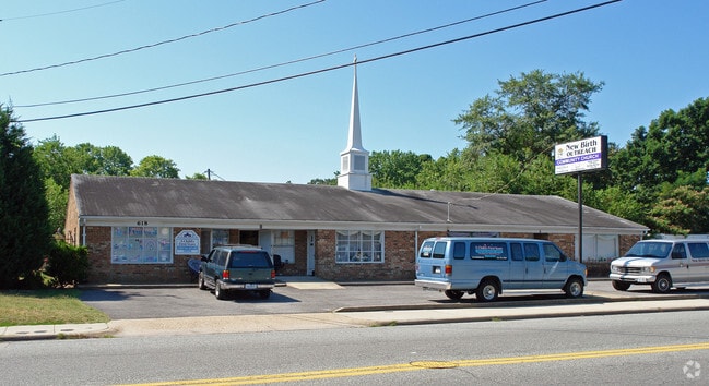
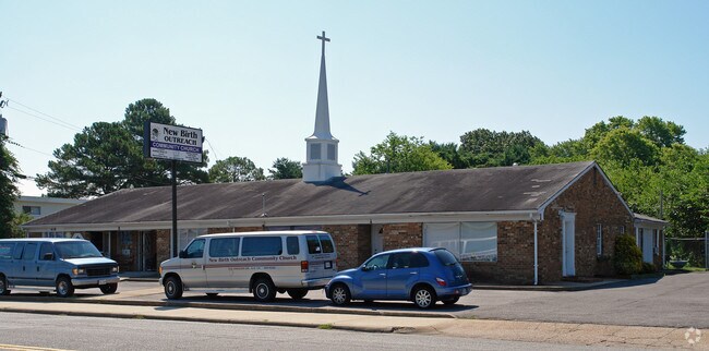
Property Record
618 Dresden Dr, Newport News, VA 23601
NEARBY LISTINGS FOR SALE OR LEASE
Property Detail
618 Dresden Dr
Virginia Beach-Norfolk-Newport News, VA-NC
Ivy Farms
241.00-07-17
G 203.40X250X51.57X292.49
Commercialnec
Newport News
X
Virginia
5155270015H
g
2025
0.73 AC
2025
Oyster Point
031604
Hampton Roads
5,018 SF
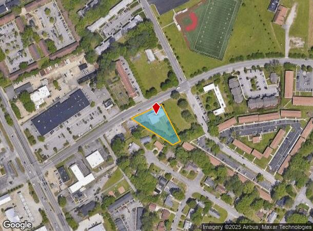
DEMOGRAPHICS near 618 Dresden Dr
1 Mile
3 Mile
5 Mile
2024 Total Population
12,855
76,350
171,350
2029 Population
12,729
75,891
172,324
Pop Growth 2024-2029
(0.98%)
(0.60%)
+ 0.57%
Average Age
39
39
38
2024 Total Households
5,472
31,720
72,236
HH Growth 2024-2029
(1.11%)
(0.69%)
+ 0.45%
Median Household Inc
$58,203
$63,286
$64,266
Avg Household Size
2.30
2.20
2.30
2024 Avg HH Vehicles
2.00
2.00
2.00
Median Home Value
$211,012
$233,234
$251,186
Median Year Built
1969
1976
1982
Nearby Places
Map Layers
Map Styles
 Street
 Aerial
- Restaurants
- Banks
- Shops
- Fitness
- Groceries
PUBLIC TRANSPORTATION
COMMUTER RAIL
Newport News (Northeast Regional - Amtrak)
DRIVE
WALK
Distance
Newport News (Northeast Regional - Amtrak)
6 min
2.8 mi
AIRPORT
Newport News/Williamsburg International
DRIVE
WALK
Distance
Newport News/Williamsburg International
14 min
6.8 mi
Norfolk International
DRIVE
WALK
Distance
Norfolk International
36 min
23.5 mi
Freight Ports
Virginia Port Authority - Newport News
DRIVE
WALK
Distance
Virginia Port Authority - Newport News
12 min
6.3 mi
Nearby Properties
Address
Land Use
TOTAL SIZE
Lot Size
Zoning
Address
Land Use
TOTAL SIZE
Lot Size
Zoning
551,257 SF
53.88 AC
O2 P1
Address
Land Use
TOTAL SIZE
Lot Size
Zoning
15,621 SF
67.16 AC
P1
Address
Land Use
TOTAL SIZE
Lot Size
Zoning
271,000 SF
24.28 AC
P1
Address
Land Use
TOTAL SIZE
Lot Size
Zoning
228,261 SF
48.49 AC
6 R-11 ONE
Address
Land Use
TOTAL SIZE
Lot Size
Zoning
464,936 SF
33.26 AC
R7
Address
Land Use
TOTAL SIZE
Lot Size
Zoning
68,814 SF
462.33 AC
P1
Address
Land Use
TOTAL SIZE
Lot Size
Zoning
35,125 SF
5.81 AC
R9
Address
Land Use
TOTAL SIZE
Lot Size
Zoning
25 AC
R8
Address
Land Use
TOTAL SIZE
Lot Size
Zoning
264,447 SF
2.30 AC
C4
Address
Land Use
TOTAL SIZE
Lot Size
Zoning
13.01 AC
R7
Address
Land Use
TOTAL SIZE
Lot Size
Zoning
4.62 AC
C4
Address
Land Use
TOTAL SIZE
Lot Size
Zoning
22,652 SF
74.72 AC
P1
Address
Land Use
TOTAL SIZE
Lot Size
Zoning
4.10 AC
R9
Address
Land Use
TOTAL SIZE
Lot Size
Zoning
281,232 SF
17.16 AC
9 R-M MULT
Address
Land Use
TOTAL SIZE
Lot Size
Zoning
107,790 SF
5.66 AC
31 HRC-1 H
Address
Land Use
TOTAL SIZE
Lot Size
Zoning
100 SF
14 AC
R7
Address
Land Use
TOTAL SIZE
Lot Size
Zoning
7,362 SF
19.76 AC
9 R-M MULT
Address
Land Use
TOTAL SIZE
Lot Size
Zoning
11.95 AC
R8
Address
Land Use
TOTAL SIZE
Lot Size
Zoning
517,920 SF
1.56 AC
C4
Address
Land Use
TOTAL SIZE
Lot Size
Zoning
8.09 AC
R8
Address
Land Use
TOTAL SIZE
Lot Size
Zoning
20.73 AC
R7
Address
Land Use
TOTAL SIZE
Lot Size
Zoning
44,999 SF
63.89 AC
P1
Address
Land Use
TOTAL SIZE
Lot Size
Zoning
46.94 AC
39 LFA-4 L
Address
Land Use
TOTAL SIZE
Lot Size
Zoning
3.95 AC
C4
Address
Land Use
TOTAL SIZE
Lot Size
Zoning
60,000 SF
1.64 AC
C4
Address
Land Use
TOTAL SIZE
Lot Size
Zoning
4.60 AC
C4
Address
Land Use
TOTAL SIZE
Lot Size
Zoning
129,400 SF
28.73 AC
P1
Address
Land Use
TOTAL SIZE
Lot Size
Zoning
100 SF
11.10 AC
R7
Address
Land Use
TOTAL SIZE
Lot Size
Zoning
15,224 SF
3 AC
R9
Address
Land Use
TOTAL SIZE
Lot Size
Zoning
123,236 SF
24.90 AC
14 C-2 LIM
The World's #1 Commercial Real Estate Marketplace
Connect with us
© 2025 CoStar Group
The information above has been obtained from sources believed reliable. While we do not doubt its accuracy we have not verified it and make no guarantee, warranty or representation about it. It is your responsibility to independently confirm its accuracy and completeness. Any projections, opinions, assumptions, or estimates used are for example only and do not represent the current or future performance of the property. The value of this transaction to you depends on tax and other factors which should be evaluated by your tax, financial, and legal advisors. You and your advisors should conduct a careful, independent investigation of the property to determine to your satisfaction the suitability of the property for your needs.