Property Record
618 N Belt Line Rd, Irving, TX 75061
NEARBY LISTINGS FOR SALE OR LEASE
Property Detail
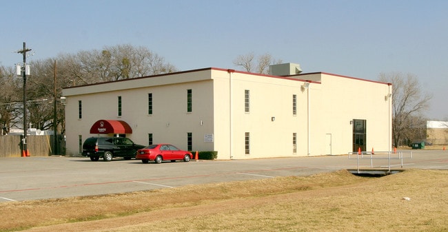
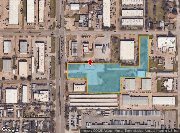
618 N Belt Line Rd
Dallas-Fort Worth-Arlington, TX
Dayspring Family Church Of Christ
320928900A01R0000
DAYSPRING FAMILY CHURCH OF CHRIST BLK A LT 1R ACS 5.285 VOL97066/0334 DD031297 CO-DC 0928900A01R00 1CI0928900A
Religious
Dallas
X
Texas
48113C0305L
1r
0
5.29 AC
2025
West Brookhollow
014406
Dallas/Ft Worth
15,300 SF
DEMOGRAPHICS near 618 N Belt Line Rd
1 Mile
3 Mile
5 Mile
2024 Total Population
18,213
124,091
242,801
2029 Population
17,967
122,361
242,308
Pop Growth 2024-2029
(1.35%)
(1.39%)
(0.20%)
Average Age
36
35
35
2024 Total Households
6,126
41,774
90,219
HH Growth 2024-2029
(1.62%)
(1.64%)
(0.11%)
Median Household Inc
$51,157
$57,045
$63,457
Avg Household Size
2.90
2.90
2.60
2024 Avg HH Vehicles
2.00
2.00
2.00
Median Home Value
$218,294
$215,667
$232,488
Median Year Built
1979
1977
1982
Nearby Places
Map Layers
Map Styles
 Street
 Aerial
- Restaurants
- Banks
- Shops
- Fitness
- Groceries
PUBLIC TRANSPORTATION
COMMUTER RAIL
West Irving (Trinity Railway Express - Dallas Area Rapid Transit (DART))
DRIVE
WALK
Distance
West Irving (Trinity Railway Express - Dallas Area Rapid Transit (DART))
4 min
1.4 mi
DRIVE
WALK
Distance
4 min
1.8 mi
AIRPORT
Dallas-Fort Worth International
DRIVE
WALK
Distance
Dallas-Fort Worth International
15 min
8.4 mi
Dallas Love Field
DRIVE
WALK
Distance
Dallas Love Field
20 min
12.0 mi
Nearby Properties
Address
Land Use
TOTAL SIZE
Lot Size
Zoning
Address
Land Use
TOTAL SIZE
Lot Size
Zoning
12,780,691 SF
0.08 AC
Z392
Address
Land Use
TOTAL SIZE
Lot Size
Zoning
422,880 SF
20.06 AC
Z177
Address
Land Use
TOTAL SIZE
Lot Size
Zoning
738,276 SF
40.57 AC
Z243
Address
Land Use
TOTAL SIZE
Lot Size
Zoning
683,300 SF
40.23 AC
Z01
Address
Land Use
TOTAL SIZE
Lot Size
Zoning
266,586 SF
11.47 AC
Address
Land Use
TOTAL SIZE
Lot Size
Zoning
341,925 SF
17.78 AC
Z49
Address
Land Use
TOTAL SIZE
Lot Size
Zoning
576,000 SF
55.36 AC
Z123
Address
Land Use
TOTAL SIZE
Lot Size
Zoning
336,302 SF
16.74 AC
Z393
Address
Land Use
TOTAL SIZE
Lot Size
Zoning
151,552 SF
16 AC
Z58
Address
Land Use
TOTAL SIZE
Lot Size
Zoning
413,524 SF
24.70 AC
Z198
Address
Land Use
TOTAL SIZE
Lot Size
Zoning
281,078 SF
16.08 AC
Z393
Address
Land Use
TOTAL SIZE
Lot Size
Zoning
585,000 SF
27.06 AC
Z123
Address
Land Use
TOTAL SIZE
Lot Size
Zoning
520,000 SF
28.92 AC
Z123
Address
Land Use
TOTAL SIZE
Lot Size
Zoning
563,300 SF
27.40 AC
Z128
Address
Land Use
TOTAL SIZE
Lot Size
Zoning
344,676 SF
15 AC
Z393
Address
Land Use
TOTAL SIZE
Lot Size
Zoning
500,256 SF
25.64 AC
Z123
Address
Land Use
TOTAL SIZE
Lot Size
Zoning
263,483 SF
11.68 AC
Z393
Address
Land Use
TOTAL SIZE
Lot Size
Zoning
278,600 SF
16.92 AC
Z176
Address
Land Use
TOTAL SIZE
Lot Size
Zoning
193,212 SF
9.68 AC
Z177
Address
Land Use
TOTAL SIZE
Lot Size
Zoning
214,728 SF
12.99 AC
RMR2
Address
Land Use
TOTAL SIZE
Lot Size
Zoning
246,720 SF
16.65 AC
Z198
Address
Land Use
TOTAL SIZE
Lot Size
Zoning
241,780 SF
16.46 AC
RMR2
Address
Land Use
TOTAL SIZE
Lot Size
Zoning
198,036 SF
12.86 AC
RMR2
Address
Land Use
TOTAL SIZE
Lot Size
Zoning
401,600 SF
23.94 AC
Z236
Address
Land Use
TOTAL SIZE
Lot Size
Zoning
643,370 SF
22.95 AC
Z393
Address
Land Use
TOTAL SIZE
Lot Size
Zoning
230,000 SF
12.40 AC
Z393
Address
Land Use
TOTAL SIZE
Lot Size
Zoning
216,265 SF
10.66 AC
Z243
Address
Land Use
TOTAL SIZE
Lot Size
Zoning
197,458 SF
9.10 AC
Z393
Address
Land Use
TOTAL SIZE
Lot Size
Zoning
120,000 SF
9.94 AC
Z393
Address
Land Use
TOTAL SIZE
Lot Size
Zoning
423,700 SF
23.29 AC
Z236
The World's #1 Commercial Real Estate Marketplace
Connect with us
© 2025 CoStar Group
The information above has been obtained from sources believed reliable. While we do not doubt its accuracy we have not verified it and make no guarantee, warranty or representation about it. It is your responsibility to independently confirm its accuracy and completeness. Any projections, opinions, assumptions, or estimates used are for example only and do not represent the current or future performance of the property. The value of this transaction to you depends on tax and other factors which should be evaluated by your tax, financial, and legal advisors. You and your advisors should conduct a careful, independent investigation of the property to determine to your satisfaction the suitability of the property for your needs.