Property Record
618 W Van Buren Ave, Harlingen, TX 78550

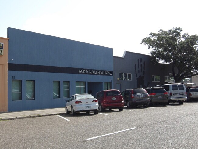
This Property Is For Sale
NEARBY LISTINGS FOR SALE OR LEASE
Property Detail
618 W Van Buren Ave
Brownsville-Harlingen, TX
Harlingen Original Townsite (Vol 2 Pg 14
150000-0640-021000
HARLINGEN ORIGINAL TOWNSITE LTS 21-22 BLK 64
Commercialnec
Cameron
X
Texas
48061C0255F
21-22
2024
0.16 AC
2025
Downtown Harlingen
010900
Brownsville/Harlingen
5,000 SF
DEMOGRAPHICS near 618 W Van Buren Ave
1 Mile
3 Mile
5 Mile
2024 Total Population
12,411
67,793
94,323
2029 Population
12,780
69,339
96,330
Pop Growth 2024-2029
+ 2.97%
+ 2.28%
+ 2.13%
Average Age
37
36
37
2024 Total Households
4,134
23,436
32,403
HH Growth 2024-2029
+ 2.95%
+ 2.28%
+ 2.09%
Median Household Inc
$31,785
$47,265
$51,031
Avg Household Size
2.80
2.80
2.80
2024 Avg HH Vehicles
2.00
2.00
2.00
Median Home Value
$63,885
$93,978
$105,085
Median Year Built
1970
1984
1986
Nearby Places
Map Layers
Map Styles
 Street
 Aerial
- Restaurants
- Banks
- Shops
- Fitness
- Groceries
PUBLIC TRANSPORTATION
AIRPORT
Valley International
DRIVE
WALK
Distance
Valley International
9 min
4.5 mi
Brownsville/South Padre Island International
DRIVE
WALK
Distance
Brownsville/South Padre Island International
38 min
28.1 mi
Freight Ports
Port of Brownsville
DRIVE
WALK
Distance
Port of Brownsville
31 min
25.7 mi
Nearby Properties
Address
Land Use
TOTAL SIZE
Lot Size
Zoning
Address
Land Use
TOTAL SIZE
Lot Size
Zoning
758,640 SF
11.31 AC
Address
Land Use
TOTAL SIZE
Lot Size
Zoning
427,448 SF
6.94 AC
Address
Land Use
TOTAL SIZE
Lot Size
Zoning
186,716 SF
13.31 AC
C
Address
Land Use
TOTAL SIZE
Lot Size
Zoning
246,234 SF
16.40 AC
Address
Land Use
TOTAL SIZE
Lot Size
Zoning
43,540 SF
26.19 AC
C
Address
Land Use
TOTAL SIZE
Lot Size
Zoning
293,886 SF
23.57 AC
Address
Land Use
TOTAL SIZE
Lot Size
Zoning
171,714 SF
16.03 AC
C
Address
Land Use
TOTAL SIZE
Lot Size
Zoning
100,090 SF
15 AC
Address
Land Use
TOTAL SIZE
Lot Size
Zoning
74,848 SF
2.30 AC
Address
Land Use
TOTAL SIZE
Lot Size
Zoning
391,617 SF
23.20 AC
C
Address
Land Use
TOTAL SIZE
Lot Size
Zoning
41,182 SF
34.14 AC
M-R
Address
Land Use
TOTAL SIZE
Lot Size
Zoning
176,365 SF
14.65 AC
Address
Land Use
TOTAL SIZE
Lot Size
Zoning
135,258 SF
4.26 AC
C
Address
Land Use
TOTAL SIZE
Lot Size
Zoning
148,596 SF
1 AC
Address
Land Use
TOTAL SIZE
Lot Size
Zoning
72,063 SF
2.29 AC
Address
Land Use
TOTAL SIZE
Lot Size
Zoning
134,518 SF
10.01 AC
Address
Land Use
TOTAL SIZE
Lot Size
Zoning
152,724 SF
17.78 AC
Address
Land Use
TOTAL SIZE
Lot Size
Zoning
63,450 SF
2.88 AC
Address
Land Use
TOTAL SIZE
Lot Size
Zoning
13,924 SF
31.33 AC
C
Address
Land Use
TOTAL SIZE
Lot Size
Zoning
77,189 SF
3.28 AC
Address
Land Use
TOTAL SIZE
Lot Size
Zoning
177,812 SF
21.40 AC
C
Address
Land Use
TOTAL SIZE
Lot Size
Zoning
15,085 SF
51.10 AC
C
Address
Land Use
TOTAL SIZE
Lot Size
Zoning
62,764 SF
10 AC
Address
Land Use
TOTAL SIZE
Lot Size
Zoning
16,508 SF
347.82 AC
Address
Land Use
TOTAL SIZE
Lot Size
Zoning
61,920 SF
5.60 AC
C
Address
Land Use
TOTAL SIZE
Lot Size
Zoning
76,756 SF
15.35 AC
Address
Land Use
TOTAL SIZE
Lot Size
Zoning
63,381 SF
3.15 AC
Address
Land Use
TOTAL SIZE
Lot Size
Zoning
81,569 SF
36.61 AC
Address
Land Use
TOTAL SIZE
Lot Size
Zoning
91,630 SF
11.17 AC
Address
Land Use
TOTAL SIZE
Lot Size
Zoning
89,508 SF
9.90 AC
The World's #1 Commercial Real Estate Marketplace
Connect with us
© 2026 CoStar Group
The information above has been obtained from sources believed reliable. While we do not doubt its accuracy we have not verified it and make no guarantee, warranty or representation about it. It is your responsibility to independently confirm its accuracy and completeness. Any projections, opinions, assumptions, or estimates used are for example only and do not represent the current or future performance of the property. The value of this transaction to you depends on tax and other factors which should be evaluated by your tax, financial, and legal advisors. You and your advisors should conduct a careful, independent investigation of the property to determine to your satisfaction the suitability of the property for your needs.