Property Record
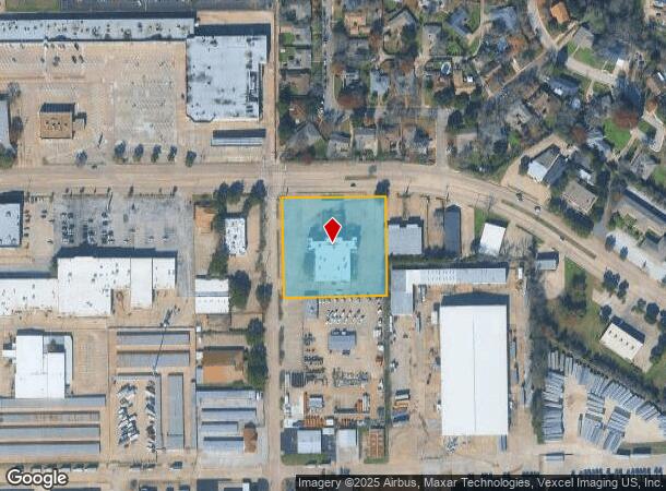
618 W Wheatland Rd, Duncanville, TX 75116

NEARBY LISTINGS FOR SALE OR LEASE
Property Detail
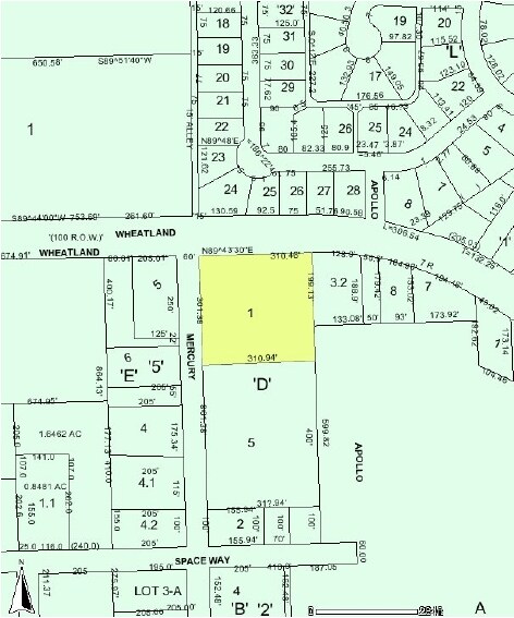
618 W Wheatland Rd
Dallas-Fort Worth-Arlington, TX
Duncanville Ind Dist 4Th Inst
22033500040030000
DUNCANVILLE IND DIST 4TH INST PT LOT D LOT 3 2.1416 AC INT20080087699 DD03142008 CO-DC 0335000400300 6CV03350004
Publicschool
Dallas
X
Texas
48113C0470K
d,3
0
2.14 AC
2025
Southwest Dallas
016513
Dallas/Ft Worth
13,614 SF
DEMOGRAPHICS near 618 W Wheatland Rd
1 Mile
3 Mile
5 Mile
2024 Total Population
10,976
89,240
178,184
2029 Population
10,770
87,776
175,731
Pop Growth 2024-2029
(1.88%)
(1.64%)
(1.38%)
Average Age
38
37
37
2024 Total Households
3,568
30,772
61,388
HH Growth 2024-2029
(2.16%)
(1.81%)
(1.54%)
Median Household Inc
$66,562
$55,235
$59,293
Avg Household Size
3.00
2.80
2.80
2024 Avg HH Vehicles
2.00
2.00
2.00
Median Home Value
$203,206
$220,549
$227,557
Median Year Built
1975
1984
1985
Nearby Places
Map Layers
Map Styles
 Street
 Aerial
- Restaurants
- Banks
- Shops
- Fitness
- Groceries
PUBLIC TRANSPORTATION
AIRPORT
Dallas Love Field
DRIVE
WALK
Distance
Dallas Love Field
30 min
19.6 mi
Dallas-Fort Worth International
DRIVE
WALK
Distance
Dallas-Fort Worth International
34 min
25.2 mi
Nearby Properties
Address
Land Use
TOTAL SIZE
Lot Size
Zoning
Address
Land Use
TOTAL SIZE
Lot Size
Zoning
726,662 SF
44.94 AC
Z239
Address
Land Use
TOTAL SIZE
Lot Size
Zoning
350,000 SF
31.28 AC
Z239
Address
Land Use
TOTAL SIZE
Lot Size
Zoning
399,458 SF
24.51 AC
MF2
Address
Land Use
TOTAL SIZE
Lot Size
Zoning
381,633 SF
21.25 AC
Z239
Address
Land Use
TOTAL SIZE
Lot Size
Zoning
217,510 SF
67.57 AC
Z268
Address
Land Use
TOTAL SIZE
Lot Size
Zoning
172,840 SF
49.65 AC
Z164
Address
Land Use
TOTAL SIZE
Lot Size
Zoning
374,400 SF
6.15 AC
Z150
Address
Land Use
TOTAL SIZE
Lot Size
Zoning
287,697 SF
18.15 AC
Z411
Address
Land Use
TOTAL SIZE
Lot Size
Zoning
274,581 SF
15.55 AC
Z46
Address
Land Use
TOTAL SIZE
Lot Size
Zoning
305,724 SF
7.02 AC
Z357
Address
Land Use
TOTAL SIZE
Lot Size
Zoning
237,127 SF
12.43 AC
Z164
Address
Land Use
TOTAL SIZE
Lot Size
Zoning
350,000 SF
19.77 AC
Z109
Address
Land Use
TOTAL SIZE
Lot Size
Zoning
305,727 SF
25.02 AC
Z06
Address
Land Use
TOTAL SIZE
Lot Size
Zoning
186,100 SF
11.12 AC
Address
Land Use
TOTAL SIZE
Lot Size
Zoning
179,100 SF
9.91 AC
Z163
Address
Land Use
TOTAL SIZE
Lot Size
Zoning
180,659 SF
8.19 AC
Z137
Address
Land Use
TOTAL SIZE
Lot Size
Zoning
220,975 SF
10.52 AC
Z151
Address
Land Use
TOTAL SIZE
Lot Size
Zoning
235,897 SF
7.97 AC
Z150
Address
Land Use
TOTAL SIZE
Lot Size
Zoning
230,513 SF
18.44 AC
Z239
Address
Land Use
TOTAL SIZE
Lot Size
Zoning
160,113 SF
9.45 AC
Z187
Address
Land Use
TOTAL SIZE
Lot Size
Zoning
160,113 SF
10.42 AC
Z187
Address
Land Use
TOTAL SIZE
Lot Size
Zoning
194,837 SF
10.79 AC
Z09
Address
Land Use
TOTAL SIZE
Lot Size
Zoning
161,560 SF
9 AC
Z163
Address
Land Use
TOTAL SIZE
Lot Size
Zoning
189,584 SF
10.09 AC
Z09
Address
Land Use
TOTAL SIZE
Lot Size
Zoning
213,351 SF
9.88 AC
Z164
Address
Land Use
TOTAL SIZE
Lot Size
Zoning
216,983 SF
11.25 AC
Z163
Address
Land Use
TOTAL SIZE
Lot Size
Zoning
210,125 SF
7 AC
Z150
Address
Land Use
TOTAL SIZE
Lot Size
Zoning
189,052 SF
17.95 AC
Z239
Address
Land Use
TOTAL SIZE
Lot Size
Zoning
176,388 SF
6.94 AC
Z150
Address
Land Use
TOTAL SIZE
Lot Size
Zoning
221,090 SF
16.83 AC
Z208
The World's #1 Commercial Real Estate Marketplace
Connect with us
© 2025 CoStar Group
The information above has been obtained from sources believed reliable. While we do not doubt its accuracy we have not verified it and make no guarantee, warranty or representation about it. It is your responsibility to independently confirm its accuracy and completeness. Any projections, opinions, assumptions, or estimates used are for example only and do not represent the current or future performance of the property. The value of this transaction to you depends on tax and other factors which should be evaluated by your tax, financial, and legal advisors. You and your advisors should conduct a careful, independent investigation of the property to determine to your satisfaction the suitability of the property for your needs.