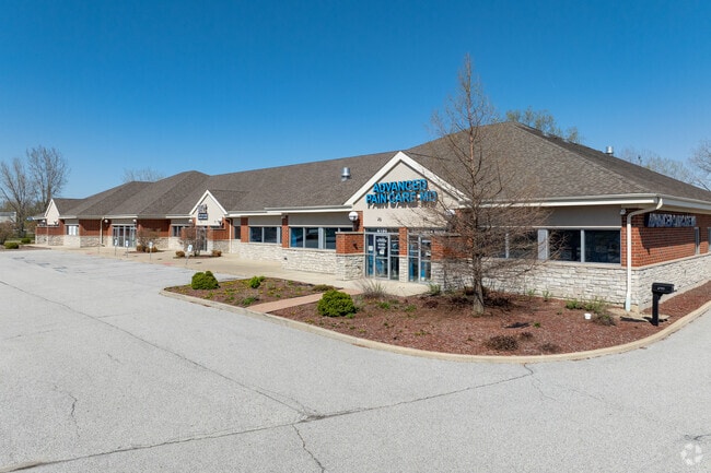
Property Record
6181 Marcella Blvd, Hobart, IN 46342
Current Lease Availabilities
NEARBY LISTINGS FOR SALE OR LEASE
Property Detail
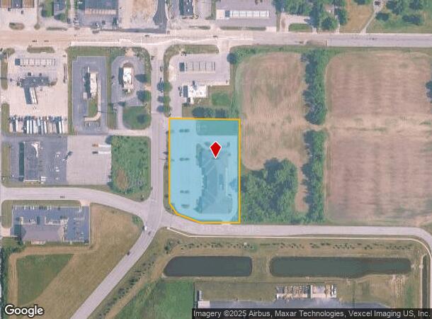
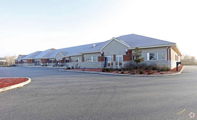
6181 Marcella Blvd
Chicago-Naperville-Elgin, IL-IN-WI
Hobart
45-12-11-102-004.000-046
HOBART SQUARE I
Officebuilding
Lake
X
Indiana
18089C0164E
1
2024
2.77 AC
2025
Indiana
042302
Chicago
23,292 SF
DEMOGRAPHICS near 6181 Marcella Blvd
1 Mile
3 Mile
5 Mile
2024 Total Population
2,772
43,474
109,016
2029 Population
2,741
44,175
110,453
Pop Growth 2024-2029
(1.12%)
+ 1.61%
+ 1.32%
Average Age
40
40
40
2024 Total Households
1,054
16,933
43,407
HH Growth 2024-2029
(1.33%)
+ 1.48%
+ 1.29%
Median Household Inc
$89,130
$51,878
$53,946
Avg Household Size
2.60
2.50
2.40
2024 Avg HH Vehicles
2.00
2.00
2.00
Median Home Value
$217,108
$150,404
$158,886
Median Year Built
1969
1965
1968
Nearby Places
Map Layers
Map Styles
 Street
 Aerial
- Restaurants
- Banks
- Shops
- Fitness
- Groceries
PUBLIC TRANSPORTATION
COMMUTER RAIL
Miller (Gary) Station (South Shore Line - Northern Indiana Commuter Transportation District (South Shore Line))
DRIVE
WALK
Distance
Miller (Gary) Station (South Shore Line - Northern Indiana Commuter Transportation District (South Shore Line))
14 min
9.3 mi
AIRPORT
Chicago Midway International
DRIVE
WALK
Distance
Chicago Midway International
58 min
38.5 mi
Freight Ports
Port Milwaukee
DRIVE
WALK
Distance
Port Milwaukee
158 min
123.8 mi
Nearby Properties
Address
Land Use
TOTAL SIZE
Lot Size
Zoning
Address
Land Use
TOTAL SIZE
Lot Size
Zoning
722,810 SF
64.65 AC
R33
Address
Land Use
TOTAL SIZE
Lot Size
Zoning
713,953 SF
39.61 AC
Address
Land Use
TOTAL SIZE
Lot Size
Zoning
552,100 SF
49.14 AC
Address
Land Use
TOTAL SIZE
Lot Size
Zoning
590,274 SF
48.18 AC
Address
Land Use
TOTAL SIZE
Lot Size
Zoning
862,805 SF
36.93 AC
R33
Address
Land Use
TOTAL SIZE
Lot Size
Zoning
623,283 SF
44.38 AC
Address
Land Use
TOTAL SIZE
Lot Size
Zoning
359,024 SF
43 AC
Address
Land Use
TOTAL SIZE
Lot Size
Zoning
159,548 SF
16.18 AC
Address
Land Use
TOTAL SIZE
Lot Size
Zoning
177,628 SF
12.95 AC
R3
Address
Land Use
TOTAL SIZE
Lot Size
Zoning
237,204 SF
28.82 AC
Address
Land Use
TOTAL SIZE
Lot Size
Zoning
194,027 SF
13.55 AC
Address
Land Use
TOTAL SIZE
Lot Size
Zoning
171,546 SF
19 AC
Address
Land Use
TOTAL SIZE
Lot Size
Zoning
108,193 SF
2.42 AC
Address
Land Use
TOTAL SIZE
Lot Size
Zoning
190,352 SF
12.36 AC
Address
Land Use
TOTAL SIZE
Lot Size
Zoning
126,603 SF
8.81 AC
Address
Land Use
TOTAL SIZE
Lot Size
Zoning
153,602 SF
15.81 AC
R33
Address
Land Use
TOTAL SIZE
Lot Size
Zoning
102,255 SF
3.96 AC
R33
Address
Land Use
TOTAL SIZE
Lot Size
Zoning
149,808 SF
15.07 AC
Address
Land Use
TOTAL SIZE
Lot Size
Zoning
97,674 SF
29.16 AC
Address
Land Use
TOTAL SIZE
Lot Size
Zoning
199,154 SF
15.70 AC
Address
Land Use
TOTAL SIZE
Lot Size
Zoning
159,117 SF
14.85 AC
R33
Address
Land Use
TOTAL SIZE
Lot Size
Zoning
62,076 SF
6.23 AC
Address
Land Use
TOTAL SIZE
Lot Size
Zoning
77,383 SF
2.92 AC
Address
Land Use
TOTAL SIZE
Lot Size
Zoning
185,876 SF
11.60 AC
R33
Address
Land Use
TOTAL SIZE
Lot Size
Zoning
109,220 SF
6.42 AC
Address
Land Use
TOTAL SIZE
Lot Size
Zoning
34,306 SF
9.56 AC
Address
Land Use
TOTAL SIZE
Lot Size
Zoning
153,352 SF
23.97 AC
Address
Land Use
TOTAL SIZE
Lot Size
Zoning
159,134 SF
22 AC
Address
Land Use
TOTAL SIZE
Lot Size
Zoning
112,309 SF
7.24 AC
Address
Land Use
TOTAL SIZE
Lot Size
Zoning
103,356 SF
7 AC
The World's #1 Commercial Real Estate Marketplace
Connect with us
© 2026 CoStar Group
The information above has been obtained from sources believed reliable. While we do not doubt its accuracy we have not verified it and make no guarantee, warranty or representation about it. It is your responsibility to independently confirm its accuracy and completeness. Any projections, opinions, assumptions, or estimates used are for example only and do not represent the current or future performance of the property. The value of this transaction to you depends on tax and other factors which should be evaluated by your tax, financial, and legal advisors. You and your advisors should conduct a careful, independent investigation of the property to determine to your satisfaction the suitability of the property for your needs.