Property Record
6185 Huntley Rd, Columbus, OH 43229

Save to a Folder
{{folder.Name}}
{{folder.ListingIds.length}} Properties
{{folder.ListingIds.length}} Property
Create a New Folder
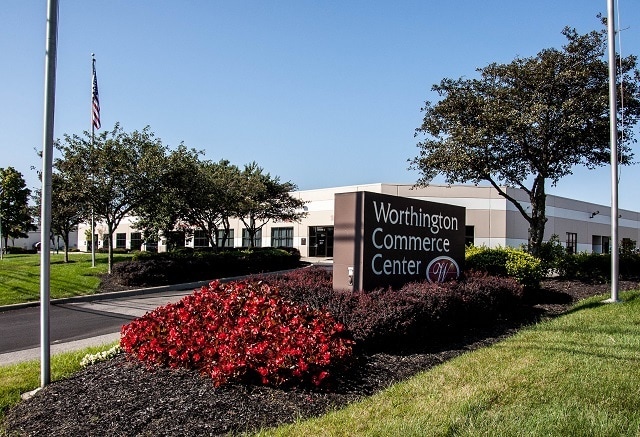
Property Detail
6185 Huntley Rd
100-006549
WORTHINGTON COMMERCE CENTER CONDOMINIUMS UNIT 6185 E
Commercialcondominium
FRANKLIN
B and X Area of moderate flood hazard, usually the area between the limits of the 100-year and 500-year floods.
Ohio
2024
0.09 AC
2025
Worthington
006722
Columbus
1,699 SF
Columbus, OH
NEARBY LISTINGS FOR SALE OR LEASE
DEMOGRAPHICS near 6185 Huntley Rd
1 mile
3 mile
5 mile
2025 Total Population
11,451
117,503
318,385
2030 Population
11,713
119,829
326,959
Pop Growth 2025-2030
+ 2.29%
+ 1.98%
+ 2.69%
Average Age
38
39
38
2025 Total Households
4,937
49,111
133,383
HH Growth 2025-2030
+ 2.41%
+ 2.17%
+ 2.88%
Median Household Inc
$59,112
$72,328
$76,807
Avg Household Size
2.30
2.30
2.30
2025 Avg HH Vehicles
2.00
2.00
2.00
Median Home Value
$351,679
$305,563
$317,694
Median Year Built
1966
1972
1976
Nearby Places
Map Layers
Map Styles
 Street
 Aerial
Layers
 Traffic
 Biking
Places
Listings with unknown addresses are not visible on the map
- Restaurants
- Banks
- Shops
- Fitness
- Groceries
PUBLIC TRANSPORTATION
AIRPORT
John Glenn Columbus International
Drive
Walk
Distance
John Glenn Columbus International
20 min
14.4 mi
Rickenbacker International
Drive
Walk
Distance
Rickenbacker International
34 min
23.5 mi
Freight Ports
Port of Toledo
Drive
Walk
Distance
Port of Toledo
173 min
135.9 mi
SALE & LEASE HISTORY
LISTING DATE
SALE/LEASE

May 16, 2025
For Lease
Jun 06, 2017
For Lease
Jun 03, 2022
For Lease
Jul 18, 2019
For Lease
Jan 13, 2021
For Lease
Nearby Properties
Address
Land Use
TOTAL SIZE
Lot Size
Zoning
Address
Land Use
TOTAL SIZE
Lot Size
Zoning
133,425 SF
0.44 AC
Address
Land Use
TOTAL SIZE
Lot Size
Zoning
320,155 SF
84.68 AC
Address
Land Use
TOTAL SIZE
Lot Size
Zoning
206,724 SF
7.60 AC
Address
Land Use
TOTAL SIZE
Lot Size
Zoning
356,770 SF
2.65 AC
Address
Land Use
TOTAL SIZE
Lot Size
Zoning
286,169 SF
11.08 AC
Address
Land Use
TOTAL SIZE
Lot Size
Zoning
425,872 SF
10.05 AC
Address
Land Use
TOTAL SIZE
Lot Size
Zoning
166,396 SF
11.68 AC
Address
Land Use
TOTAL SIZE
Lot Size
Zoning
413,781 SF
78.36 AC
Address
Land Use
TOTAL SIZE
Lot Size
Zoning
244,602 SF
27.30 AC
Address
Land Use
TOTAL SIZE
Lot Size
Zoning
162,728 SF
4.80 AC
Address
Land Use
TOTAL SIZE
Lot Size
Zoning
187,562 SF
8.76 AC
Address
Land Use
TOTAL SIZE
Lot Size
Zoning
62,702 SF
38.69 AC
Address
Land Use
TOTAL SIZE
Lot Size
Zoning
167,479 SF
36.79 AC
Address
Land Use
TOTAL SIZE
Lot Size
Zoning
273,264 SF
7.35 AC
Address
Land Use
TOTAL SIZE
Lot Size
Zoning
147,582 SF
5.75 AC
Address
Land Use
TOTAL SIZE
Lot Size
Zoning
168,427 SF
6.70 AC
Address
Land Use
TOTAL SIZE
Lot Size
Zoning
170,237 SF
97.38 AC
Address
Land Use
TOTAL SIZE
Lot Size
Zoning
368,077 SF
7.87 AC
Address
Land Use
TOTAL SIZE
Lot Size
Zoning
184,756 SF
23.53 AC
Address
Land Use
TOTAL SIZE
Lot Size
Zoning
358,264 SF
10.88 AC
Address
Land Use
TOTAL SIZE
Lot Size
Zoning
148.89 AC
Address
Land Use
TOTAL SIZE
Lot Size
Zoning
85,228 SF
45.03 AC
Address
Land Use
TOTAL SIZE
Lot Size
Zoning
111,168 SF
19.43 AC
Address
Land Use
TOTAL SIZE
Lot Size
Zoning
85,530 SF
11.75 AC
Address
Land Use
TOTAL SIZE
Lot Size
Zoning
65,125 SF
11.98 AC
Address
Land Use
TOTAL SIZE
Lot Size
Zoning
242,825 SF
3.22 AC
Address
Land Use
TOTAL SIZE
Lot Size
Zoning
407,325 SF
27.53 AC
Address
Land Use
TOTAL SIZE
Lot Size
Zoning
35,172 SF
0.93 AC
Address
Land Use
TOTAL SIZE
Lot Size
Zoning
130,059 SF
25.97 AC
Address
Land Use
TOTAL SIZE
Lot Size
Zoning
140,912 SF
36.59 AC
The World's #1 Commercial Real Estate Marketplace
Connect with us
© 2026 CoStar Group
The information above has been obtained from sources believed reliable. While we do not doubt its accuracy we have not verified it and make no guarantee, warranty or representation about it. It is your responsibility to independently confirm its accuracy and completeness. Any projections, opinions, assumptions, or estimates used are for example only and do not represent the current or future performance of the property. The value of this transaction to you depends on tax and other factors which should be evaluated by your tax, financial, and legal advisors. You and your advisors should conduct a careful, independent investigation of the property to determine to your satisfaction the suitability of the property for your needs.