Property Record
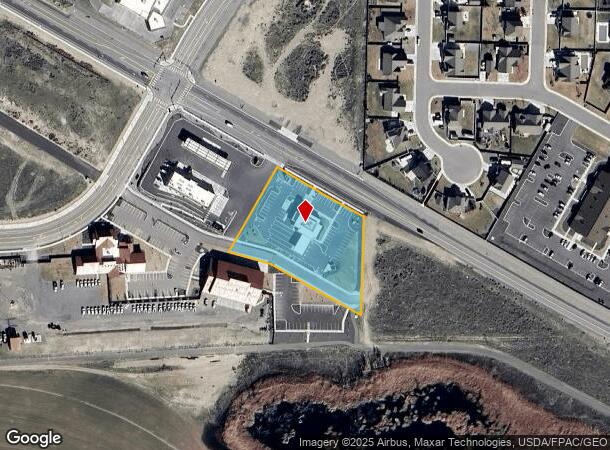
6185 Keene Rd, West Richland, WA 99353
NEARBY LISTINGS FOR SALE OR LEASE
Property Detail
6185 Keene Rd
Other Market Areas
Belmont Business District
Kennewick-Richland, WA
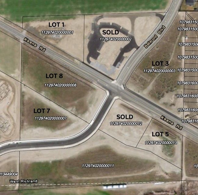
LOT 5, BELMONT BUSINESS DISTRICT ACCORDING OT THE RECORD OF SURVEY FOR A BOUNDARY LINE ADJUSTMENT RECORDED IN VOLUME 1 OF SURVEYS, PAGE 4841, RECORDS OF BENTON COUNTY, WASHINGTON. TOGETHER WITH: THAT PORTION OF LOT 4, BELMONT BUSINESS DISTRICT ACCORD
112974020000013
Benton
Financialbuilding
Washington
2024
5
2024
1.83 AC
010701
Yakima/Kennewick
4,222 SF
DEMOGRAPHICS near 6185 Keene Rd
1 Mile
3 Mile
5 Mile
2024 Total Population
6,131
22,736
62,146
2029 Population
6,562
24,547
66,820
Pop Growth 2024-2029
+ 7.03%
+ 7.97%
+ 7.52%
Average Age
37
38
38
2024 Total Households
2,068
7,849
23,268
HH Growth 2024-2029
+ 7.06%
+ 8.01%
+ 7.52%
Median Household Inc
$119,413
$120,900
$98,009
Avg Household Size
3.00
2.90
2.60
2024 Avg HH Vehicles
2.00
3.00
2.00
Median Home Value
$377,535
$395,885
$377,827
Median Year Built
2003
2000
1991
Nearby Places
Map Layers
Map Styles
 Street
 Aerial
- Restaurants
- Banks
- Shops
- Fitness
- Groceries
PUBLIC TRANSPORTATION
AIRPORT
Tri-Cities
DRIVE
WALK
Distance
Tri-Cities
23 min
14.8 mi
Freight Ports
Port of Tacoma
DRIVE
WALK
Distance
Port of Tacoma
259 min
224.6 mi
SALE & LEASE HISTORY
LISTING DATE
SALE/LEASE

Mar 12, 2019
For Sale
Nearby Properties
Address
Land Use
TOTAL SIZE
Lot Size
Zoning
Address
Land Use
TOTAL SIZE
Lot Size
Zoning
118,956 SF
30.48 AC
Address
Land Use
TOTAL SIZE
Lot Size
Zoning
82,226 SF
40 AC
G.M.A. AGR
Address
Land Use
TOTAL SIZE
Lot Size
Zoning
216,270 SF
22.32 AC
Address
Land Use
TOTAL SIZE
Lot Size
Zoning
113,052 SF
3.32 AC
Address
Land Use
TOTAL SIZE
Lot Size
Zoning
109,517 SF
4.67 AC
Address
Land Use
TOTAL SIZE
Lot Size
Zoning
76,389 SF
14.43 AC
Address
Land Use
TOTAL SIZE
Lot Size
Zoning
102,146 SF
40 AC
Address
Land Use
TOTAL SIZE
Lot Size
Zoning
126,251 SF
7 AC
Address
Land Use
TOTAL SIZE
Lot Size
Zoning
81,928 SF
4.49 AC
Address
Land Use
TOTAL SIZE
Lot Size
Zoning
74,920 SF
4.57 AC
Address
Land Use
TOTAL SIZE
Lot Size
Zoning
42,782 SF
72.06 AC
Address
Land Use
TOTAL SIZE
Lot Size
Zoning
127,195 SF
9.16 AC
Address
Land Use
TOTAL SIZE
Lot Size
Zoning
74,352 SF
13.55 AC
RICHLAND -
Address
Land Use
TOTAL SIZE
Lot Size
Zoning
123,936 SF
5.66 AC
Address
Land Use
TOTAL SIZE
Lot Size
Zoning
62,733 SF
14.60 AC
Address
Land Use
TOTAL SIZE
Lot Size
Zoning
35,488 SF
4.99 AC
Address
Land Use
TOTAL SIZE
Lot Size
Zoning
56,700 SF
6.47 AC
Address
Land Use
TOTAL SIZE
Lot Size
Zoning
71,700 SF
9.33 AC
Address
Land Use
TOTAL SIZE
Lot Size
Zoning
Address
Land Use
TOTAL SIZE
Lot Size
Zoning
59,102 SF
5.39 AC
WEST RICHL
Address
Land Use
TOTAL SIZE
Lot Size
Zoning
Address
Land Use
TOTAL SIZE
Lot Size
Zoning
39,096 SF
2.18 AC
Address
Land Use
TOTAL SIZE
Lot Size
Zoning
28,865 SF
8.42 AC
Address
Land Use
TOTAL SIZE
Lot Size
Zoning
11,625 SF
29.71 AC
Address
Land Use
TOTAL SIZE
Lot Size
Zoning
54,283 SF
12 AC
Address
Land Use
TOTAL SIZE
Lot Size
Zoning
56,902 SF
3.69 AC
Address
Land Use
TOTAL SIZE
Lot Size
Zoning
24,000 SF
5.45 AC
Address
Land Use
TOTAL SIZE
Lot Size
Zoning
23,347 SF
5 AC
Address
Land Use
TOTAL SIZE
Lot Size
Zoning
28.83 AC
Address
Land Use
TOTAL SIZE
Lot Size
Zoning
28.65 AC
The World's #1 Commercial Real Estate Marketplace
Connect with us
© 2025 CoStar Group
The information above has been obtained from sources believed reliable. While we do not doubt its accuracy we have not verified it and make no guarantee, warranty or representation about it. It is your responsibility to independently confirm its accuracy and completeness. Any projections, opinions, assumptions, or estimates used are for example only and do not represent the current or future performance of the property. The value of this transaction to you depends on tax and other factors which should be evaluated by your tax, financial, and legal advisors. You and your advisors should conduct a careful, independent investigation of the property to determine to your satisfaction the suitability of the property for your needs.