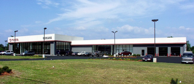
Property Record
618A Route 303, Blauvelt, NY 10913
NEARBY LISTINGS FOR SALE OR LEASE
Property Detail
618A Route 303
New York-Jersey City-White Plains, NY-NJ
45/101/841/9.1
392489-065-018-0001-008-000-0000
Rockland
Residentialacreage
New York
X
8.0
36087C0179G
0.03 AC
2023
Orangetown
2024
Northern New Jersey
013002
DEMOGRAPHICS near 618A Route 303
1 Mile
3 Mile
5 Mile
2024 Total Population
2,384
41,661
144,755
2029 Population
2,376
41,413
143,818
Pop Growth 2024-2029
(0.34%)
(0.60%)
(0.65%)
Average Age
41
43
42
2024 Total Households
758
15,391
51,312
HH Growth 2024-2029
(0.40%)
(0.70%)
(0.75%)
Median Household Inc
$132,459
$121,115
$119,620
Avg Household Size
3.00
2.60
2.70
2024 Avg HH Vehicles
2.00
2.00
2.00
Median Home Value
$655,147
$595,074
$590,121
Median Year Built
1968
1963
1965
Nearby Places
- Restaurants
- Banks
- Shops
- Fitness
- Groceries
PUBLIC TRANSPORTATION
COMMUTER RAIL
Nanuet (Pascack Valley Line - NJ Transit Commuter Rail (NJ Transit))
DRIVE
WALK
Distance
Nanuet (Pascack Valley Line - NJ Transit Commuter Rail (NJ Transit))
9 min
5.1 mi
Pearl River (Pascack Valley Line - NJ Transit Commuter Rail (NJ Transit))
DRIVE
WALK
Distance
Pearl River (Pascack Valley Line - NJ Transit Commuter Rail (NJ Transit))
12 min
7.0 mi
AIRPORT
Westchester County
DRIVE
WALK
Distance
Westchester County
29 min
20.3 mi
LaGuardia
DRIVE
WALK
Distance
LaGuardia
46 min
28.5 mi
Newark Liberty International
DRIVE
WALK
Distance
Newark Liberty International
42 min
32.1 mi
Freight Ports
NY - Red Hook Container Terminal
DRIVE
WALK
Distance
NY - Red Hook Container Terminal
56 min
34.4 mi
Nearby Properties
Address
Land Use
TOTAL SIZE
Lot Size
Zoning
Address
Land Use
TOTAL SIZE
Lot Size
Zoning
415,374 SF
8.43 AC
H
Address
Land Use
TOTAL SIZE
Lot Size
Zoning
4,540,462 SF
30.89 AC
Address
Land Use
TOTAL SIZE
Lot Size
Zoning
220,594 SF
22.30 AC
R-40
Address
Land Use
TOTAL SIZE
Lot Size
Zoning
237,408 SF
14.97 AC
R-40
Address
Land Use
TOTAL SIZE
Lot Size
Zoning
298,975 SF
63.32 AC
03 - MULTI
Address
Land Use
TOTAL SIZE
Lot Size
Zoning
231,978 SF
48.30 AC
R-40
Address
Land Use
TOTAL SIZE
Lot Size
Zoning
191,148 SF
32.26 AC
R-40
Address
Land Use
TOTAL SIZE
Lot Size
Zoning
114,520 SF
6.71 AC
R4
Address
Land Use
TOTAL SIZE
Lot Size
Zoning
25.52 AC
Address
Land Use
TOTAL SIZE
Lot Size
Zoning
50,280 SF
24.37 AC
Address
Land Use
TOTAL SIZE
Lot Size
Zoning
108,264 SF
14.90 AC
R-18
Address
Land Use
TOTAL SIZE
Lot Size
Zoning
67,962 SF
8.30 AC
02 - SINGL
Address
Land Use
TOTAL SIZE
Lot Size
Zoning
31.50 AC
R-15
Address
Land Use
TOTAL SIZE
Lot Size
Zoning
302.70 AC
R-40
Address
Land Use
TOTAL SIZE
Lot Size
Zoning
63,268 SF
104.70 AC
R-40
Address
Land Use
TOTAL SIZE
Lot Size
Zoning
66,920 SF
17.70 AC
LO
Address
Land Use
TOTAL SIZE
Lot Size
Zoning
345,670 SF
49.40 AC
Address
Land Use
TOTAL SIZE
Lot Size
Zoning
247,496 SF
24.20 AC
Address
Land Use
TOTAL SIZE
Lot Size
Zoning
1.10 AC
R-3
Address
Land Use
TOTAL SIZE
Lot Size
Zoning
56,436 SF
7.06 AC
R-40
Address
Land Use
TOTAL SIZE
Lot Size
Zoning
249,150 SF
61.41 AC
R-40
Address
Land Use
TOTAL SIZE
Lot Size
Zoning
984 SF
3.10 AC
LI
Address
Land Use
TOTAL SIZE
Lot Size
Zoning
1,887 SF
245.60 AC
02 - SINGL
Address
Land Use
TOTAL SIZE
Lot Size
Zoning
441.47 AC
R-40
Address
Land Use
TOTAL SIZE
Lot Size
Zoning
112,628 SF
11.80 AC
LO
Address
Land Use
TOTAL SIZE
Lot Size
Zoning
500,448 SF
29.92 AC
Address
Land Use
TOTAL SIZE
Lot Size
Zoning
4,621 SF
134.83 AC
Address
Land Use
TOTAL SIZE
Lot Size
Zoning
142,608 SF
5.60 AC
HRA
Address
Land Use
TOTAL SIZE
Lot Size
Zoning
Address
Land Use
TOTAL SIZE
Lot Size
Zoning
184.50 AC
R-40
The World's #1 Commercial Real Estate Marketplace
Connect with us
© 2025 CoStar Group
The information above has been obtained from sources believed reliable. While we do not doubt its accuracy we have not verified it and make no guarantee, warranty or representation about it. It is your responsibility to independently confirm its accuracy and completeness. Any projections, opinions, assumptions, or estimates used are for example only and do not represent the current or future performance of the property. The value of this transaction to you depends on tax and other factors which should be evaluated by your tax, financial, and legal advisors. You and your advisors should conduct a careful, independent investigation of the property to determine to your satisfaction the suitability of the property for your needs.