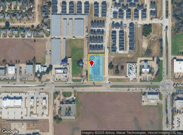
Property Record
619 E Belt Line Rd, Cedar Hill, TX 75104

NEARBY LISTINGS FOR SALE OR LEASE
Property Detail
619 E Belt Line Rd
Dallas-Fort Worth-Arlington, TX
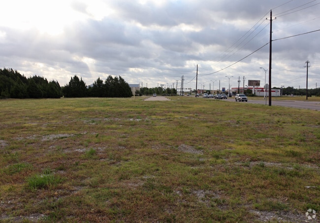
Snapclean Carwash
167506300A0010000
SNAPCLEAN CARWASH BLK A LT 1 ACS 1.171 INT201800208686 DD08032018 CO-DC 7506300A00100 5CH7506300A
Carwash
Dallas
X
Texas
48139C0035G
1
2024
1.17 AC
2025
C Hill/Dunc'vlle/Deso
016629
Dallas/Ft Worth
4,512 SF
DEMOGRAPHICS near 619 E Belt Line Rd
1 Mile
3 Mile
5 Mile
2024 Total Population
14,240
62,898
144,111
2029 Population
13,956
61,962
144,028
Pop Growth 2024-2029
(1.99%)
(1.49%)
(0.06%)
Average Age
36
38
38
2024 Total Households
4,786
20,971
49,193
HH Growth 2024-2029
(2.15%)
(1.65%)
(0.21%)
Median Household Inc
$70,008
$81,707
$73,938
Avg Household Size
2.90
2.90
2.90
2024 Avg HH Vehicles
2.00
2.00
2.00
Median Home Value
$209,667
$245,530
$239,377
Median Year Built
1992
1994
1990
Nearby Places
Map Layers
Map Styles
 Street
 Aerial
- Restaurants
- Banks
- Shops
- Fitness
- Groceries
PUBLIC TRANSPORTATION
AIRPORT
Dallas Love Field
DRIVE
WALK
Distance
Dallas Love Field
32 min
22.3 mi
Dallas-Fort Worth International
DRIVE
WALK
Distance
Dallas-Fort Worth International
37 min
27.2 mi
Freight Ports
Port of Shreveport
DRIVE
WALK
Distance
Port of Shreveport
222 min
206.7 mi
Nearby Properties
Address
Land Use
TOTAL SIZE
Lot Size
Zoning
Address
Land Use
TOTAL SIZE
Lot Size
Zoning
446,164 SF
13.45 AC
Z137
Address
Land Use
TOTAL SIZE
Lot Size
Zoning
494,366 SF
43.30 AC
Z137
Address
Land Use
TOTAL SIZE
Lot Size
Zoning
374,277 SF
17.41 AC
Z137
Address
Land Use
TOTAL SIZE
Lot Size
Zoning
217,510 SF
67.57 AC
Z268
Address
Land Use
TOTAL SIZE
Lot Size
Zoning
248,819 SF
92.33 AC
AA1
Address
Land Use
TOTAL SIZE
Lot Size
Zoning
219,128 SF
11.62 AC
Z160
Address
Land Use
TOTAL SIZE
Lot Size
Zoning
219,152 SF
14.31 AC
Z160
Address
Land Use
TOTAL SIZE
Lot Size
Zoning
188,600 SF
13.52 AC
Z160
Address
Land Use
TOTAL SIZE
Lot Size
Zoning
115,000 SF
15.89 AC
Z137
Address
Land Use
TOTAL SIZE
Lot Size
Zoning
223,899 SF
10 AC
Z160
Address
Land Use
TOTAL SIZE
Lot Size
Zoning
180,659 SF
8.19 AC
Z137
Address
Land Use
TOTAL SIZE
Lot Size
Zoning
168,476 SF
8.15 AC
Z137
Address
Land Use
TOTAL SIZE
Lot Size
Zoning
299,986 SF
26.32 AC
Z137
Address
Land Use
TOTAL SIZE
Lot Size
Zoning
176,010 SF
16.72 AC
Z137
Address
Land Use
TOTAL SIZE
Lot Size
Zoning
347,760 SF
21.61 AC
Z109
Address
Land Use
TOTAL SIZE
Lot Size
Zoning
174,708 SF
9.78 AC
Z360
Address
Land Use
TOTAL SIZE
Lot Size
Zoning
308,880 SF
19.03 AC
Z109
Address
Land Use
TOTAL SIZE
Lot Size
Zoning
177,692 SF
9.07 AC
Z09
Address
Land Use
TOTAL SIZE
Lot Size
Zoning
118,617 SF
23.20 AC
Z360
Address
Land Use
TOTAL SIZE
Lot Size
Zoning
321,600 SF
19.58 AC
Z109
Address
Land Use
TOTAL SIZE
Lot Size
Zoning
93,342 SF
8.19 AC
Z97
Address
Land Use
TOTAL SIZE
Lot Size
Zoning
148,971 SF
15.11 AC
Z137
Address
Land Use
TOTAL SIZE
Lot Size
Zoning
135,000 SF
23.91 AC
Z360
Address
Land Use
TOTAL SIZE
Lot Size
Zoning
156,000 SF
11.31 AC
Z14
Address
Land Use
TOTAL SIZE
Lot Size
Zoning
30,926 SF
109.20 AC
AA1
Address
Land Use
TOTAL SIZE
Lot Size
Zoning
42,218 SF
10.03 AC
Z137
Address
Land Use
TOTAL SIZE
Lot Size
Zoning
223,789 SF
25.66 AC
Z137
Address
Land Use
TOTAL SIZE
Lot Size
Zoning
123,120 SF
10.02 AC
Z109
Address
Land Use
TOTAL SIZE
Lot Size
Zoning
209,051 SF
37.20 AC
Z312
Address
Land Use
TOTAL SIZE
Lot Size
Zoning
143,331 SF
12.74 AC
Z363
The World's #1 Commercial Real Estate Marketplace
Connect with us
© 2026 CoStar Group
The information above has been obtained from sources believed reliable. While we do not doubt its accuracy we have not verified it and make no guarantee, warranty or representation about it. It is your responsibility to independently confirm its accuracy and completeness. Any projections, opinions, assumptions, or estimates used are for example only and do not represent the current or future performance of the property. The value of this transaction to you depends on tax and other factors which should be evaluated by your tax, financial, and legal advisors. You and your advisors should conduct a careful, independent investigation of the property to determine to your satisfaction the suitability of the property for your needs.