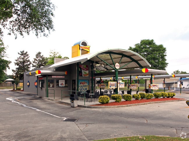
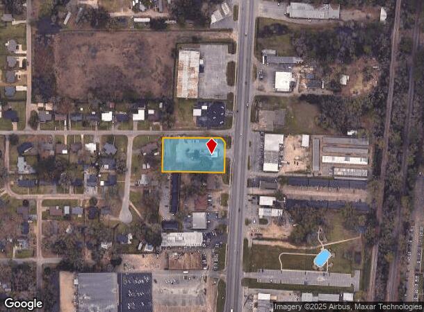
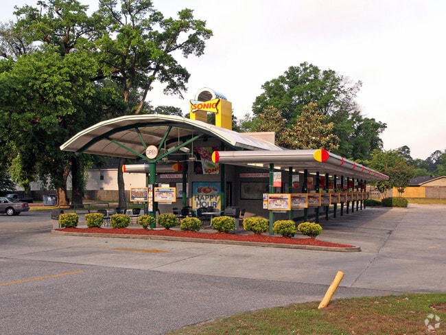
Property Record
619 Saraland Blvd S, Saraland, AL 36571
NEARBY LISTINGS FOR SALE OR LEASE
Property Detail
619 Saraland Blvd S
Mobile, AL
Fast Foodrestaurant Site
22-02-03-3-000-065.001
BEG AT NE COR OF LOT 37 CRAIG PL ACCD TO MBK 16/65 SD PT BEING ON S R/W/L OF CRAIG DR RUN S 89 DEG 44 MIN 35 SEC E ALG SD S R/W/L OF CRAIG DR 274.8 FT TO PC OF A CURV TO RT HAVIN A CEN ANG OF 92 DEG 57 MIN 35 SEC & A RAD 23.74 FT TH CONT ALG SD S R/W
Restaurantdrivein
Mobile
X
Alabama
01097C0437L
35-37
2025
1.14 AC
2024
Prichard/Saraland
005400
Mobile
1,346 SF
DEMOGRAPHICS near 619 Saraland Blvd S
1 Mile
3 Mile
5 Mile
2024 Total Population
4,419
15,753
39,132
2029 Population
4,366
15,498
39,017
Pop Growth 2024-2029
(1.20%)
(1.62%)
(0.29%)
Average Age
38
39
40
2024 Total Households
1,852
6,325
15,309
HH Growth 2024-2029
(1.30%)
(1.71%)
(0.32%)
Median Household Inc
$44,272
$52,343
$42,724
Avg Household Size
2.40
2.50
2.50
2024 Avg HH Vehicles
2.00
2.00
2.00
Median Home Value
$141,620
$147,261
$136,038
Median Year Built
1973
1972
1973
Nearby Places
Map Layers
Map Styles
 Street
 Aerial
- Restaurants
- Banks
- Shops
- Fitness
- Groceries
PUBLIC TRANSPORTATION
AIRPORT
Mobile International
DRIVE
WALK
Distance
Mobile International
24 min
14.2 mi
Mobile Regional
DRIVE
WALK
Distance
Mobile Regional
34 min
19.5 mi
Nearby Properties
Address
Land Use
TOTAL SIZE
Lot Size
Zoning
Address
Land Use
TOTAL SIZE
Lot Size
Zoning
66,138 SF
35.24 AC
Address
Land Use
TOTAL SIZE
Lot Size
Zoning
9,100 SF
34.07 AC
Address
Land Use
TOTAL SIZE
Lot Size
Zoning
35,775 SF
22.48 AC
Address
Land Use
TOTAL SIZE
Lot Size
Zoning
26,871 SF
26.30 AC
Address
Land Use
TOTAL SIZE
Lot Size
Zoning
187,257 SF
33.10 AC
Address
Land Use
TOTAL SIZE
Lot Size
Zoning
21,700 SF
6.98 AC
Address
Land Use
TOTAL SIZE
Lot Size
Zoning
197,471 SF
15.90 AC
Address
Land Use
TOTAL SIZE
Lot Size
Zoning
66,678 SF
2.29 AC
Address
Land Use
TOTAL SIZE
Lot Size
Zoning
57,084 SF
1.97 AC
Address
Land Use
TOTAL SIZE
Lot Size
Zoning
45,980 SF
10.72 AC
Address
Land Use
TOTAL SIZE
Lot Size
Zoning
1,104 SF
6.01 AC
Address
Land Use
TOTAL SIZE
Lot Size
Zoning
116,512 SF
9.60 AC
Address
Land Use
TOTAL SIZE
Lot Size
Zoning
125,239 SF
11.20 AC
Address
Land Use
TOTAL SIZE
Lot Size
Zoning
35,952 SF
5.37 AC
Address
Land Use
TOTAL SIZE
Lot Size
Zoning
54,965 SF
1.97 AC
Address
Land Use
TOTAL SIZE
Lot Size
Zoning
294,193 SF
7.06 AC
Address
Land Use
TOTAL SIZE
Lot Size
Zoning
18,818 SF
6.21 AC
Address
Land Use
TOTAL SIZE
Lot Size
Zoning
86,174 SF
9.30 AC
Address
Land Use
TOTAL SIZE
Lot Size
Zoning
40,245 SF
1.99 AC
Address
Land Use
TOTAL SIZE
Lot Size
Zoning
114,942 SF
28.61 AC
Address
Land Use
TOTAL SIZE
Lot Size
Zoning
73,680 SF
27 AC
Address
Land Use
TOTAL SIZE
Lot Size
Zoning
5,384 SF
18 AC
Address
Land Use
TOTAL SIZE
Lot Size
Zoning
48,304 SF
3.28 AC
Address
Land Use
TOTAL SIZE
Lot Size
Zoning
128,250 SF
13.83 AC
Address
Land Use
TOTAL SIZE
Lot Size
Zoning
21,800 SF
6 AC
Address
Land Use
TOTAL SIZE
Lot Size
Zoning
76,682 SF
9.62 AC
Address
Land Use
TOTAL SIZE
Lot Size
Zoning
34,504 SF
12 AC
Address
Land Use
TOTAL SIZE
Lot Size
Zoning
50,740 SF
1.57 AC
Address
Land Use
TOTAL SIZE
Lot Size
Zoning
200,472 SF
9.18 AC
Address
Land Use
TOTAL SIZE
Lot Size
Zoning
59,400 SF
16.72 AC
The World's #1 Commercial Real Estate Marketplace
Connect with us
© 2025 CoStar Group
The information above has been obtained from sources believed reliable. While we do not doubt its accuracy we have not verified it and make no guarantee, warranty or representation about it. It is your responsibility to independently confirm its accuracy and completeness. Any projections, opinions, assumptions, or estimates used are for example only and do not represent the current or future performance of the property. The value of this transaction to you depends on tax and other factors which should be evaluated by your tax, financial, and legal advisors. You and your advisors should conduct a careful, independent investigation of the property to determine to your satisfaction the suitability of the property for your needs.