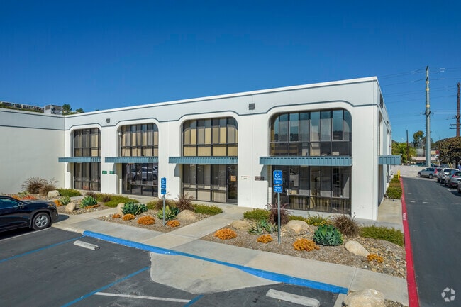
Property Record
6190 Fairmount Ave, San Diego, CA 92120


Current Lease Availabilities
NEARBY LISTINGS FOR SALE OR LEASE
Property Detail
6190 Fairmount Ave
461-150-10
Parcel Map No 12483
Industrialgeneral
PAR 1 TR PM12483
AE
San Diego
06073C1636H
California
2024
3.69 AC
2025
Mission Gorge
009603
San Diego
34,131 SF
San Diego-Carlsbad, CA
DEMOGRAPHICS near 6190 Fairmount Ave
1 Mile
3 Mile
5 Mile
2024 Total Population
17,786
209,529
469,239
2029 Population
17,991
209,038
467,746
Pop Growth 2024-2029
+ 1.15%
(0.23%)
(0.32%)
Average Age
37
36
38
2024 Total Households
8,541
83,104
191,377
HH Growth 2024-2029
+ 1.11%
(0.28%)
(0.36%)
Median Household Inc
$79,416
$76,549
$80,916
Avg Household Size
2.00
2.40
2.30
2024 Avg HH Vehicles
2.00
2.00
2.00
Median Home Value
$633,541
$746,672
$727,715
Median Year Built
1981
1975
1973
Nearby Places
Map Layers
Map Styles
 Street
 Aerial
- Restaurants
- Banks
- Shops
- Fitness
- Groceries
PUBLIC TRANSPORTATION
COMMUTER RAIL
Old Town Transit Center (Coaster - San Diego North County Transit District (Coaster/Sprinter/Breeze))
DRIVE
WALK
Distance
Old Town Transit Center (Coaster - San Diego North County Transit District (Coaster/Sprinter/Breeze))
12 min
7.4 mi
San Diego (Santa Fe Depot) (Coaster - San Diego North County Transit District (Coaster/Sprinter/Breeze))
DRIVE
WALK
Distance
San Diego (Santa Fe Depot) (Coaster - San Diego North County Transit District (Coaster/Sprinter/Breeze))
14 min
9.0 mi
AIRPORT
San Diego International
DRIVE
WALK
Distance
San Diego International
15 min
8.0 mi
Nearby Properties
Address
Land Use
TOTAL SIZE
Lot Size
Zoning
Address
Land Use
TOTAL SIZE
Lot Size
Zoning
4,774 SF
74.75 AC
RM-2-5
Address
Land Use
TOTAL SIZE
Lot Size
Zoning
17.88 AC
CO-1-2
Address
Land Use
TOTAL SIZE
Lot Size
Zoning
46.03 AC
IH-2-1
Address
Land Use
TOTAL SIZE
Lot Size
Zoning
4.41 AC
CC-3-8
Address
Land Use
TOTAL SIZE
Lot Size
Zoning
8.23 AC
CUPD-CU-2-
Address
Land Use
TOTAL SIZE
Lot Size
Zoning
9.90 AC
RM-3-7
Address
Land Use
TOTAL SIZE
Lot Size
Zoning
18.70 AC
RS-1-7
Address
Land Use
TOTAL SIZE
Lot Size
Zoning
19.25 AC
CC-3-5
Address
Land Use
TOTAL SIZE
Lot Size
Zoning
5.02 AC
CC-3-8
Address
Land Use
TOTAL SIZE
Lot Size
Zoning
7.48 AC
RM-3-9
Address
Land Use
TOTAL SIZE
Lot Size
Zoning
54,240 SF
8.18 AC
MVPD-MVR-2
Address
Land Use
TOTAL SIZE
Lot Size
Zoning
13.45 AC
IL-2-1
Address
Land Use
TOTAL SIZE
Lot Size
Zoning
3.97 AC
C
Address
Land Use
TOTAL SIZE
Lot Size
Zoning
7.69 AC
MVPD-MV-M/
Address
Land Use
TOTAL SIZE
Lot Size
Zoning
13.04 AC
RM-2-5
Address
Land Use
TOTAL SIZE
Lot Size
Zoning
7.19 AC
MVPD-MV-M/
Address
Land Use
TOTAL SIZE
Lot Size
Zoning
902,919 SF
45.23 AC
MVPD-MV-CR
Address
Land Use
TOTAL SIZE
Lot Size
Zoning
6.68 AC
RM-3-7
Address
Land Use
TOTAL SIZE
Lot Size
Zoning
5.02 AC
RM-4-10
Address
Land Use
TOTAL SIZE
Lot Size
Zoning
3.36 AC
RM-4-10
Address
Land Use
TOTAL SIZE
Lot Size
Zoning
19.67 AC
RM-2-5
Address
Land Use
TOTAL SIZE
Lot Size
Zoning
2.46 AC
CC-3-5
Address
Land Use
TOTAL SIZE
Lot Size
Zoning
7.10 AC
MVPD-MV-CO
Address
Land Use
TOTAL SIZE
Lot Size
Zoning
10.20 AC
CC-3-5
Address
Land Use
TOTAL SIZE
Lot Size
Zoning
7.43 AC
MVPD-MV-CV
Address
Land Use
TOTAL SIZE
Lot Size
Zoning
7.75 AC
MVPD-MV-CO
Address
Land Use
TOTAL SIZE
Lot Size
Zoning
7.31 AC
RM-2-5
Address
Land Use
TOTAL SIZE
Lot Size
Zoning
3.99 AC
RM-3-9
Address
Land Use
TOTAL SIZE
Lot Size
Zoning
19.56 AC
RM-2-5
Address
Land Use
TOTAL SIZE
Lot Size
Zoning
1.19 AC
RM-3-9
The World's #1 Commercial Real Estate Marketplace
Connect with us
© 2025 CoStar Group
The information above has been obtained from sources believed reliable. While we do not doubt its accuracy we have not verified it and make no guarantee, warranty or representation about it. It is your responsibility to independently confirm its accuracy and completeness. Any projections, opinions, assumptions, or estimates used are for example only and do not represent the current or future performance of the property. The value of this transaction to you depends on tax and other factors which should be evaluated by your tax, financial, and legal advisors. You and your advisors should conduct a careful, independent investigation of the property to determine to your satisfaction the suitability of the property for your needs.