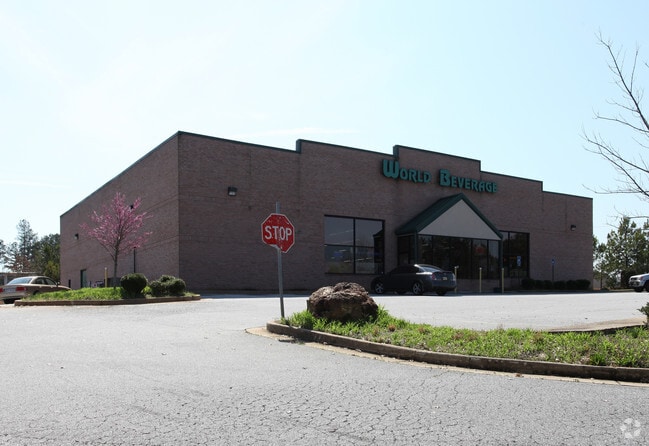
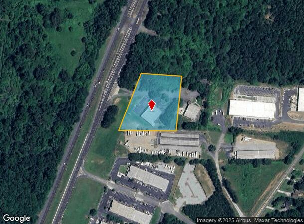
Property Record
6190 Georgia Highway 400, Cumming, GA 30028


NEARBY LISTINGS FOR SALE OR LEASE
Property Detail
6190 Georgia Highway 400
Atlanta-Sandy Springs-Roswell, GA
Hubbard Town Settingdown
250-035
14-1 423-504
Commercialnec
Forsyth
X
Georgia
13117C0060G
423
2024
2.66 AC
2025
Cumming/Forsyth Cnty
130204
Atlanta
115 SF
DEMOGRAPHICS near 6190 Georgia Highway 400
1 Mile
3 Mile
5 Mile
2024 Total Population
4,208
22,832
50,142
2029 Population
4,964
27,649
60,585
Pop Growth 2024-2029
+ 17.97%
+ 21.10%
+ 20.83%
Average Age
38
38
39
2024 Total Households
1,379
7,794
17,197
HH Growth 2024-2029
+ 18.06%
+ 21.43%
+ 21.22%
Median Household Inc
$113,804
$103,052
$102,681
Avg Household Size
3.00
2.90
2.90
2024 Avg HH Vehicles
2.00
2.00
2.00
Median Home Value
$397,344
$351,488
$369,615
Median Year Built
2005
2005
2003
Nearby Places
Map Layers
Map Styles
 Street
 Aerial
- Restaurants
- Banks
- Shops
- Fitness
- Groceries
SALE & LEASE HISTORY
LISTING DATE
SALE/LEASE

Sep 24, 2016
For Sale
Apr 16, 2024
For Sale
Nearby Properties
Address
Land Use
TOTAL SIZE
Lot Size
Zoning
Address
Land Use
TOTAL SIZE
Lot Size
Zoning
57,180 SF
61.71 AC
RES6
Address
Land Use
TOTAL SIZE
Lot Size
Zoning
28.74 AC
MP
Address
Land Use
TOTAL SIZE
Lot Size
Zoning
70,312 SF
61.79 AC
C-HB
Address
Land Use
TOTAL SIZE
Lot Size
Zoning
12,090 SF
21.69 AC
C-PCD
Address
Land Use
TOTAL SIZE
Lot Size
Zoning
24,092 SF
40 AC
RA
Address
Land Use
TOTAL SIZE
Lot Size
Zoning
57,666 SF
19.39 AC
Address
Land Use
TOTAL SIZE
Lot Size
Zoning
93,514 SF
30.24 AC
Address
Land Use
TOTAL SIZE
Lot Size
Zoning
122,225 SF
14.72 AC
C-HB
Address
Land Use
TOTAL SIZE
Lot Size
Zoning
50,875 SF
420.29 AC
A1
Address
Land Use
TOTAL SIZE
Lot Size
Zoning
19.21 AC
M1
Address
Land Use
TOTAL SIZE
Lot Size
Zoning
6,086 SF
14.85 AC
O&I
Address
Land Use
TOTAL SIZE
Lot Size
Zoning
197,360 SF
24.24 AC
C-PCD
Address
Land Use
TOTAL SIZE
Lot Size
Zoning
59,534 SF
16.93 AC
CBD
Address
Land Use
TOTAL SIZE
Lot Size
Zoning
23,424 SF
18.33 AC
C-HB
Address
Land Use
TOTAL SIZE
Lot Size
Zoning
54,674 SF
7.65 AC
UV
Address
Land Use
TOTAL SIZE
Lot Size
Zoning
84,304 SF
19.76 AC
C-PCD
Address
Land Use
TOTAL SIZE
Lot Size
Zoning
130,686 SF
41.98 AC
R2R
Address
Land Use
TOTAL SIZE
Lot Size
Zoning
229.24 AC
M1
Address
Land Use
TOTAL SIZE
Lot Size
Zoning
119,116 SF
17.01 AC
C-PCD
Address
Land Use
TOTAL SIZE
Lot Size
Zoning
23,625 SF
6.31 AC
C-HB
Address
Land Use
TOTAL SIZE
Lot Size
Zoning
39,251 SF
109.39 AC
A1
Address
Land Use
TOTAL SIZE
Lot Size
Zoning
69,903 SF
19.99 AC
RA
Address
Land Use
TOTAL SIZE
Lot Size
Zoning
53,284 SF
1.43 AC
C-HB
Address
Land Use
TOTAL SIZE
Lot Size
Zoning
37,784 SF
8 AC
C-HB
Address
Land Use
TOTAL SIZE
Lot Size
Zoning
174,860 SF
17.82 AC
C-IR
Address
Land Use
TOTAL SIZE
Lot Size
Zoning
3.90 AC
M1
Address
Land Use
TOTAL SIZE
Lot Size
Zoning
54,090 SF
8.70 AC
CBD
Address
Land Use
TOTAL SIZE
Lot Size
Zoning
40,092 SF
3.35 AC
M1
Address
Land Use
TOTAL SIZE
Lot Size
Zoning
108,800 SF
7.44 AC
C-IR
Address
Land Use
TOTAL SIZE
Lot Size
Zoning
31,423 SF
4.30 AC
CBD
The World's #1 Commercial Real Estate Marketplace
Connect with us
© 2025 CoStar Group
The information above has been obtained from sources believed reliable. While we do not doubt its accuracy we have not verified it and make no guarantee, warranty or representation about it. It is your responsibility to independently confirm its accuracy and completeness. Any projections, opinions, assumptions, or estimates used are for example only and do not represent the current or future performance of the property. The value of this transaction to you depends on tax and other factors which should be evaluated by your tax, financial, and legal advisors. You and your advisors should conduct a careful, independent investigation of the property to determine to your satisfaction the suitability of the property for your needs.