Property Record
6194 Section Rd, Ottawa Lake, MI 49267
NEARBY LISTINGS FOR SALE OR LEASE
-
-
View all Ottawa Lake listings for sale on LoopNet.com
Property Detail
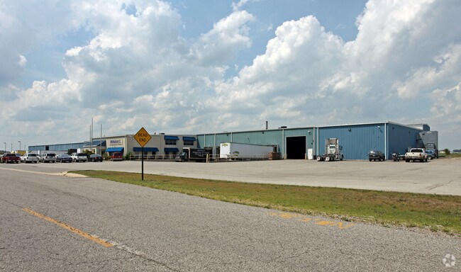
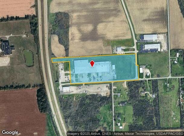
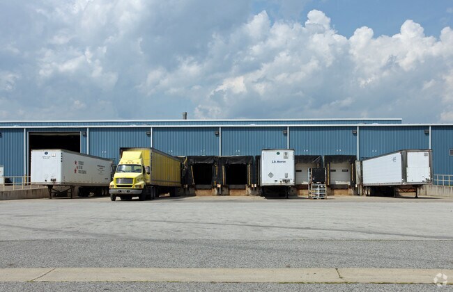
6194 Section Rd
15-034-001-20
A PARCEL OF LAND SITUATED IN WHITEFORD TOWNSHIP, MONROE COUNTY, MICHIGAN PART OF THE NE 1/4 OF SEC 34, T8S,R6E, DESCRIBED AS:
Lightindustrial
Monroe
X
Michigan
26115C0452E
15.70 AC
2024
Monroe County
2025
Detroit
833000
Monroe, MI
160,740 SF
DEMOGRAPHICS near 6194 Section Rd
1 Mile
3 Mile
5 Mile
2024 Total Population
235
23,599
83,615
2029 Population
232
23,133
82,142
Pop Growth 2024-2029
(1.28%)
(1.97%)
(1.76%)
Average Age
45
42
42
2024 Total Households
100
9,501
34,557
HH Growth 2024-2029
(2.00%)
(2.01%)
(1.84%)
Median Household Inc
$80,921
$84,341
$78,505
Avg Household Size
2.40
2.40
2.40
2024 Avg HH Vehicles
2.00
2.00
2.00
Median Home Value
$244,642
$198,687
$195,683
Median Year Built
1963
1970
1971
Nearby Places
Map Layers
Map Styles
 Street
 Aerial
- Restaurants
- Banks
- Shops
- Fitness
- Groceries
PUBLIC TRANSPORTATION
AIRPORT
Eugene F Kranz Toledo Express
DRIVE
WALK
Distance
Eugene F Kranz Toledo Express
35 min
21.1 mi
Nearby Properties
Address
Land Use
TOTAL SIZE
Lot Size
Zoning
Address
Land Use
TOTAL SIZE
Lot Size
Zoning
607,717 SF
7.39 AC
31-R3
Address
Land Use
TOTAL SIZE
Lot Size
Zoning
460,266 SF
85.36 AC
31-R1
Address
Land Use
TOTAL SIZE
Lot Size
Zoning
15.79 AC
31-B4
Address
Land Use
TOTAL SIZE
Lot Size
Zoning
312,089 SF
6.34 AC
31-B5
Address
Land Use
TOTAL SIZE
Lot Size
Zoning
238,200 SF
32.90 AC
31-R1
Address
Land Use
TOTAL SIZE
Lot Size
Zoning
106,064 SF
332 AC
M2
Address
Land Use
TOTAL SIZE
Lot Size
Zoning
174,890 SF
19.86 AC
31-R3
Address
Land Use
TOTAL SIZE
Lot Size
Zoning
135,978 SF
14.01 AC
31-B2
Address
Land Use
TOTAL SIZE
Lot Size
Zoning
78,266 SF
13.57 AC
20-S1
Address
Land Use
TOTAL SIZE
Lot Size
Zoning
70,483 SF
8.53 AC
31-R1
Address
Land Use
TOTAL SIZE
Lot Size
Zoning
54,085 SF
0.81 AC
20-S1
Address
Land Use
TOTAL SIZE
Lot Size
Zoning
62,831 SF
7.79 AC
31-R1
Address
Land Use
TOTAL SIZE
Lot Size
Zoning
41,200 SF
9.45 AC
31-MX
Address
Land Use
TOTAL SIZE
Lot Size
Zoning
61,404 SF
3.77 AC
31-R1
Address
Land Use
TOTAL SIZE
Lot Size
Zoning
99,366 SF
1.57 AC
10-RS12
Address
Land Use
TOTAL SIZE
Lot Size
Zoning
20 AC
31-R3
Address
Land Use
TOTAL SIZE
Lot Size
Zoning
9,298 SF
87.83 AC
31-R2
Address
Land Use
TOTAL SIZE
Lot Size
Zoning
118,630 SF
29.29 AC
31-R3
Address
Land Use
TOTAL SIZE
Lot Size
Zoning
12,204 SF
1 AC
31-B3
Address
Land Use
TOTAL SIZE
Lot Size
Zoning
114,755 SF
6.46 AC
31-R4
Address
Land Use
TOTAL SIZE
Lot Size
Zoning
116,704 SF
31.87 AC
Address
Land Use
TOTAL SIZE
Lot Size
Zoning
111,872 SF
3.38 AC
31-R3
Address
Land Use
TOTAL SIZE
Lot Size
Zoning
27 AC
31-R3
Address
Land Use
TOTAL SIZE
Lot Size
Zoning
36,604 SF
2.27 AC
31-R1
Address
Land Use
TOTAL SIZE
Lot Size
Zoning
73,956 SF
4.54 AC
31-R3
Address
Land Use
TOTAL SIZE
Lot Size
Zoning
48,522 SF
1.50 AC
31-R1
Address
Land Use
TOTAL SIZE
Lot Size
Zoning
176,061 SF
6.17 AC
31-R3
Address
Land Use
TOTAL SIZE
Lot Size
Zoning
48,928 SF
2.80 AC
31-B2
Address
Land Use
TOTAL SIZE
Lot Size
Zoning
67,806 SF
4.20 AC
31-B2
The World's #1 Commercial Real Estate Marketplace
Connect with us
© 2026 CoStar Group
The information above has been obtained from sources believed reliable. While we do not doubt its accuracy we have not verified it and make no guarantee, warranty or representation about it. It is your responsibility to independently confirm its accuracy and completeness. Any projections, opinions, assumptions, or estimates used are for example only and do not represent the current or future performance of the property. The value of this transaction to you depends on tax and other factors which should be evaluated by your tax, financial, and legal advisors. You and your advisors should conduct a careful, independent investigation of the property to determine to your satisfaction the suitability of the property for your needs.