Property Record
6196 N La Cholla Blvd, Tucson, AZ 85741
NEARBY LISTINGS FOR SALE OR LEASE
Property Detail
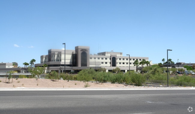
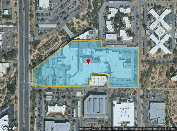
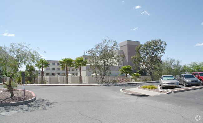
6196 N La Cholla Blvd
102-12-005E
PTN W2 NW4 12.62 AC SEC 10-13-13
Hospitalpublic
Pima
X
Arizona
04019C1660L
100
2025
12.62 AC
2025
North Tucson/Oro Valley
004613
Tucson
373,270 SF
Tucson, AZ
DEMOGRAPHICS near 6196 N La Cholla Blvd
1 Mile
3 Mile
5 Mile
2024 Total Population
8,000
68,951
169,374
2029 Population
8,304
71,154
175,441
Pop Growth 2024-2029
+ 3.80%
+ 3.20%
+ 3.58%
Average Age
45
41
41
2024 Total Households
3,123
29,580
73,538
HH Growth 2024-2029
+ 4.35%
+ 3.23%
+ 3.61%
Median Household Inc
$67,056
$60,111
$58,112
Avg Household Size
2.30
2.20
2.20
2024 Avg HH Vehicles
2.00
2.00
2.00
Median Home Value
$297,641
$246,650
$267,003
Median Year Built
1987
1982
1984
Nearby Places
Map Layers
Map Styles
 Street
 Aerial
- Restaurants
- Banks
- Shops
- Fitness
- Groceries
PUBLIC TRANSPORTATION
COMMUTER RAIL
Tucson Amtrak Station (Sunset Limited - Amtrak, Texas Eagle - Amtrak)
DRIVE
WALK
Distance
Tucson Amtrak Station (Sunset Limited - Amtrak, Texas Eagle - Amtrak)
15 min
10.0 mi
AIRPORT
Tucson International
DRIVE
WALK
Distance
Tucson International
28 min
17.5 mi
Freight Ports
Port of San Diego
DRIVE
WALK
Distance
Port of San Diego
427 min
402.4 mi
Nearby Properties
Address
Land Use
TOTAL SIZE
Lot Size
Zoning
Address
Land Use
TOTAL SIZE
Lot Size
Zoning
65,294 SF
9.58 AC
SR
Address
Land Use
TOTAL SIZE
Lot Size
Zoning
35,300 SF
5.20 AC
SR
Address
Land Use
TOTAL SIZE
Lot Size
Zoning
390,339 SF
35.51 AC
Address
Land Use
TOTAL SIZE
Lot Size
Zoning
39,508 SF
7.29 AC
MU
Address
Land Use
TOTAL SIZE
Lot Size
Zoning
131,575 SF
25.97 AC
SR
Address
Land Use
TOTAL SIZE
Lot Size
Zoning
50,340 SF
14.37 AC
HI
Address
Land Use
TOTAL SIZE
Lot Size
Zoning
22,114 SF
49.39 AC
CR1
Address
Land Use
TOTAL SIZE
Lot Size
Zoning
290,039 SF
1.98 AC
C3
Address
Land Use
TOTAL SIZE
Lot Size
Zoning
232,740 SF
177.79 AC
Address
Land Use
TOTAL SIZE
Lot Size
Zoning
5,618 SF
3.15 AC
Address
Land Use
TOTAL SIZE
Lot Size
Zoning
122,413 SF
21.85 AC
I1
Address
Land Use
TOTAL SIZE
Lot Size
Zoning
375,887 SF
28.70 AC
CR4
Address
Land Use
TOTAL SIZE
Lot Size
Zoning
388,226 SF
22 AC
CR5
Address
Land Use
TOTAL SIZE
Lot Size
Zoning
310,258 SF
17.11 AC
TR
Address
Land Use
TOTAL SIZE
Lot Size
Zoning
12,962 SF
2.80 AC
C3
Address
Land Use
TOTAL SIZE
Lot Size
Zoning
222,779 SF
8.83 AC
CR5
Address
Land Use
TOTAL SIZE
Lot Size
Zoning
19,892 SF
3.36 AC
CB1
Address
Land Use
TOTAL SIZE
Lot Size
Zoning
209,131 SF
18.55 AC
CB2
Address
Land Use
TOTAL SIZE
Lot Size
Zoning
189,753 SF
18.18 AC
VC
Address
Land Use
TOTAL SIZE
Lot Size
Zoning
280,281 SF
12.85 AC
TR
Address
Land Use
TOTAL SIZE
Lot Size
Zoning
319,196 SF
18.26 AC
TR
Address
Land Use
TOTAL SIZE
Lot Size
Zoning
24,100 SF
4.96 AC
MU
Address
Land Use
TOTAL SIZE
Lot Size
Zoning
223,640 SF
18.06 AC
CB1
Address
Land Use
TOTAL SIZE
Lot Size
Zoning
21,000 SF
9.34 AC
Address
Land Use
TOTAL SIZE
Lot Size
Zoning
278,458 SF
13.49 AC
TR
Address
Land Use
TOTAL SIZE
Lot Size
Zoning
239,878 SF
11.65 AC
TR
Address
Land Use
TOTAL SIZE
Lot Size
Zoning
311,175 SF
13.09 AC
SP
Address
Land Use
TOTAL SIZE
Lot Size
Zoning
279,055 SF
18.03 AC
CR4
Address
Land Use
TOTAL SIZE
Lot Size
Zoning
313,820 SF
18.68 AC
TR
The World's #1 Commercial Real Estate Marketplace
Connect with us
© 2026 CoStar Group
The information above has been obtained from sources believed reliable. While we do not doubt its accuracy we have not verified it and make no guarantee, warranty or representation about it. It is your responsibility to independently confirm its accuracy and completeness. Any projections, opinions, assumptions, or estimates used are for example only and do not represent the current or future performance of the property. The value of this transaction to you depends on tax and other factors which should be evaluated by your tax, financial, and legal advisors. You and your advisors should conduct a careful, independent investigation of the property to determine to your satisfaction the suitability of the property for your needs.