Property Record
62 Maritime Dr, Mystic, CT 06355


NEARBY LISTINGS FOR SALE OR LEASE
-
-
View all Mystic listings for sale on LoopNet.com
Property Detail
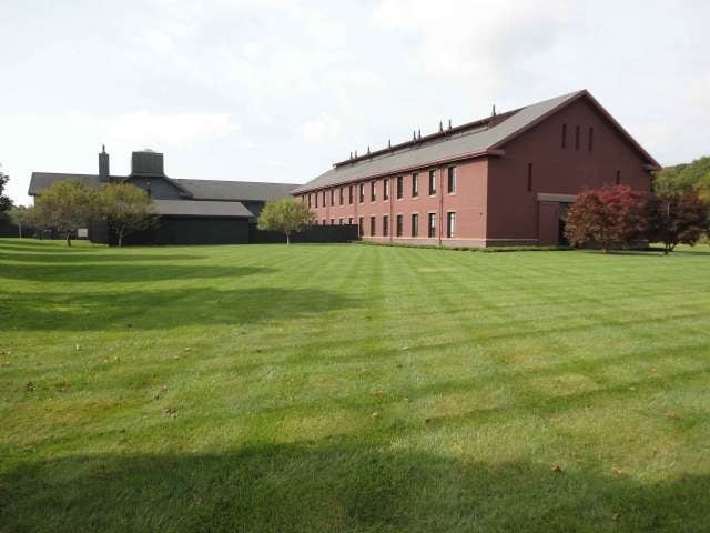
62 Maritime Dr
STON-000163-000001-000028E
New London
Industrialgeneral
Connecticut
X
28e
09011C0527J
15.63 AC
2025
SE New London
2025
Hartford
705300
Norwich-New London, CT
74,984 SF
DEMOGRAPHICS near 62 Maritime Dr
1 Mile
3 Mile
5 Mile
2024 Total Population
2,887
16,214
31,930
2029 Population
2,984
16,373
32,128
Pop Growth 2024-2029
+ 3.36%
+ 0.98%
+ 0.62%
Average Age
51
48
47
2024 Total Households
1,122
6,973
13,926
HH Growth 2024-2029
+ 3.12%
+ 0.83%
+ 0.62%
Median Household Inc
$115,026
$111,087
$100,389
Avg Household Size
2.10
2.20
2.20
2024 Avg HH Vehicles
2.00
2.00
2.00
Median Home Value
$410,191
$394,410
$379,936
Median Year Built
1982
1967
1969
Nearby Places
Map Layers
Map Styles
 Street
 Aerial
- Restaurants
- Banks
- Shops
- Fitness
- Groceries
PUBLIC TRANSPORTATION
COMMUTER RAIL
Mystic Amtrak (Northeast Regional - Amtrak)
DRIVE
WALK
Distance
Mystic Amtrak (Northeast Regional - Amtrak)
6 min
2.6 mi
Westerly Amtrak Station (Northeast Regional - Amtrak)
DRIVE
WALK
Distance
Westerly Amtrak Station (Northeast Regional - Amtrak)
14 min
8.0 mi
Freight Ports
Port of Davisville, RI
DRIVE
WALK
Distance
Port of Davisville, RI
59 min
43.3 mi
SALE & LEASE HISTORY
LISTING DATE
SALE/LEASE

Sep 24, 2016
For Sale
Dec 05, 2019
For Sale
Nearby Properties
Address
Land Use
TOTAL SIZE
Lot Size
Zoning
Address
Land Use
TOTAL SIZE
Lot Size
Zoning
18.02 AC
RM-15
Address
Land Use
TOTAL SIZE
Lot Size
Zoning
32.59 AC
RA-40
Address
Land Use
TOTAL SIZE
Lot Size
Zoning
18.17 AC
TC-80
Address
Land Use
TOTAL SIZE
Lot Size
Zoning
138,366 SF
11.20 AC
GDD
Address
Land Use
TOTAL SIZE
Lot Size
Zoning
74,433 SF
47.37 AC
RS-20
Address
Land Use
TOTAL SIZE
Lot Size
Zoning
139,952 SF
5.81 AC
GDD
Address
Land Use
TOTAL SIZE
Lot Size
Zoning
74,328 SF
19.50 AC
RR-80
Address
Land Use
TOTAL SIZE
Lot Size
Zoning
45,795 SF
5.60 AC
GDD
Address
Land Use
TOTAL SIZE
Lot Size
Zoning
120,243 SF
9.06 AC
TC-80
Address
Land Use
TOTAL SIZE
Lot Size
Zoning
40.80 AC
M-1
Address
Land Use
TOTAL SIZE
Lot Size
Zoning
7.35 AC
TC-80
Address
Land Use
TOTAL SIZE
Lot Size
Zoning
85,073 SF
17.60 AC
RA-20
Address
Land Use
TOTAL SIZE
Lot Size
Zoning
58,739 SF
21.85 AC
RU-40
Address
Land Use
TOTAL SIZE
Lot Size
Zoning
7.40 AC
M-1
Address
Land Use
TOTAL SIZE
Lot Size
Zoning
59,024 SF
3.24 AC
RS-12
Address
Land Use
TOTAL SIZE
Lot Size
Zoning
68,206 SF
6.40 AC
M-1
Address
Land Use
TOTAL SIZE
Lot Size
Zoning
19,274 SF
1.36 AC
GB-130
Address
Land Use
TOTAL SIZE
Lot Size
Zoning
1,880 SF
166.33 AC
IM
Address
Land Use
TOTAL SIZE
Lot Size
Zoning
55,089 SF
2.63 AC
GC-60
Address
Land Use
TOTAL SIZE
Lot Size
Zoning
25.88 AC
RR-80
Address
Land Use
TOTAL SIZE
Lot Size
Zoning
14.50 AC
GC-60
Address
Land Use
TOTAL SIZE
Lot Size
Zoning
46,652 SF
12.23 AC
RC-120
Address
Land Use
TOTAL SIZE
Lot Size
Zoning
0.77 AC
DB-5
Address
Land Use
TOTAL SIZE
Lot Size
Zoning
35,520 SF
1.61 AC
MDD
Address
Land Use
TOTAL SIZE
Lot Size
Zoning
39,667 SF
8.41 AC
RS-20
Address
Land Use
TOTAL SIZE
Lot Size
Zoning
48.70 AC
GB-130
Address
Land Use
TOTAL SIZE
Lot Size
Zoning
7,500 SF
2.87 AC
MC-80
Address
Land Use
TOTAL SIZE
Lot Size
Zoning
4.88 AC
TC-80
Address
Land Use
TOTAL SIZE
Lot Size
Zoning
51,929 SF
77.39 AC
RU-80
The World's #1 Commercial Real Estate Marketplace
Connect with us
© 2025 CoStar Group
The information above has been obtained from sources believed reliable. While we do not doubt its accuracy we have not verified it and make no guarantee, warranty or representation about it. It is your responsibility to independently confirm its accuracy and completeness. Any projections, opinions, assumptions, or estimates used are for example only and do not represent the current or future performance of the property. The value of this transaction to you depends on tax and other factors which should be evaluated by your tax, financial, and legal advisors. You and your advisors should conduct a careful, independent investigation of the property to determine to your satisfaction the suitability of the property for your needs.