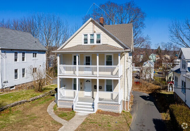
Property Record
62 S Street Ext, Bristol, CT 06010

NEARBY LISTINGS FOR SALE OR LEASE
Property Detail
62 S Street Ext
Hartford-West Hartford-East Hartford, CT
Hartford
BRIS-000029-000000-000348-000002
Connecticut
Triplex
0.21 AC
X
Bristol/Plainville
09009C0040H
Hartford
1,911 SF
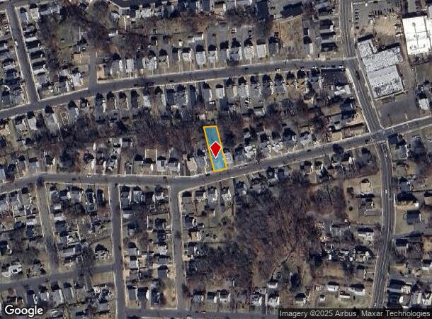
DEMOGRAPHICS near 62 S Street Ext
1 Mile
3 Mile
5 Mile
2024 Total Population
14,703
54,000
102,184
2029 Population
14,733
53,980
101,938
Pop Growth 2024-2029
+ 0.20%
(0.04%)
(0.24%)
Average Age
39
41
42
2024 Total Households
6,191
22,700
42,638
HH Growth 2024-2029
+ 0.16%
(0.07%)
(0.27%)
Median Household Inc
$64,919
$71,141
$78,491
Avg Household Size
2.30
2.30
2.30
2024 Avg HH Vehicles
1.00
2.00
2.00
Median Home Value
$194,853
$224,793
$246,433
Median Year Built
1956
1965
1968
Nearby Places
Map Layers
Map Styles
 Street
 Aerial
- Restaurants
- Banks
- Shops
- Fitness
- Groceries
PUBLIC TRANSPORTATION
AIRPORT
Bradley International
DRIVE
WALK
Distance
Bradley International
57 min
32.1 mi
Tweed/New Haven
DRIVE
WALK
Distance
Tweed/New Haven
49 min
32.8 mi
Freight Ports
Port of New Haven
DRIVE
WALK
Distance
Port of New Haven
45 min
30.5 mi
SALE & LEASE HISTORY
LISTING DATE
SALE/LEASE

Jun 17, 2019
For Sale
Nearby Properties
Address
Land Use
TOTAL SIZE
Lot Size
Zoning
Address
Land Use
TOTAL SIZE
Lot Size
Zoning
77,001 SF
54.59 AC
IP-1
Address
Land Use
TOTAL SIZE
Lot Size
Zoning
349,054 SF
12.03 AC
R-15
Address
Land Use
TOTAL SIZE
Lot Size
Zoning
139 AC
IP-25
Address
Land Use
TOTAL SIZE
Lot Size
Zoning
58,473 SF
18.20 AC
IP-1
Address
Land Use
TOTAL SIZE
Lot Size
Zoning
145,719 SF
17.90 AC
R-15
Address
Land Use
TOTAL SIZE
Lot Size
Zoning
121,917 SF
28.60 AC
R-15
Address
Land Use
TOTAL SIZE
Lot Size
Zoning
114,375 SF
12.72 AC
IP-1
Address
Land Use
TOTAL SIZE
Lot Size
Zoning
330,400 SF
36.90 AC
IP-1
Address
Land Use
TOTAL SIZE
Lot Size
Zoning
12,892 SF
20.91 AC
A
Address
Land Use
TOTAL SIZE
Lot Size
Zoning
56,184 SF
19.42 AC
BG
Address
Land Use
TOTAL SIZE
Lot Size
Zoning
171,826 SF
36.60 AC
R-15
Address
Land Use
TOTAL SIZE
Lot Size
Zoning
199,744 SF
44.70 AC
R-15
Address
Land Use
TOTAL SIZE
Lot Size
Zoning
62,232 SF
0.90 AC
BD-1
Address
Land Use
TOTAL SIZE
Lot Size
Zoning
169,727 SF
23.90 AC
R-25
Address
Land Use
TOTAL SIZE
Lot Size
Zoning
4,000 SF
13.78 AC
BG
Address
Land Use
TOTAL SIZE
Lot Size
Zoning
120,801 SF
8.35 AC
R-40
Address
Land Use
TOTAL SIZE
Lot Size
Zoning
3,084 SF
14.90 AC
BG
Address
Land Use
TOTAL SIZE
Lot Size
Zoning
133,720 SF
7.34 AC
IP-1
Address
Land Use
TOTAL SIZE
Lot Size
Zoning
51,851 SF
1.32 AC
BD-1
Address
Land Use
TOTAL SIZE
Lot Size
Zoning
52,128 SF
7.20 AC
A
Address
Land Use
TOTAL SIZE
Lot Size
Zoning
1,250 SF
14.90 AC
I
Address
Land Use
TOTAL SIZE
Lot Size
Zoning
47,218 SF
3.62 AC
BD-1
Address
Land Use
TOTAL SIZE
Lot Size
Zoning
4,209 SF
14.60 AC
A
Address
Land Use
TOTAL SIZE
Lot Size
Zoning
80,776 SF
2.49 AC
BD-1
Address
Land Use
TOTAL SIZE
Lot Size
Zoning
60,935 SF
0.92 AC
BD-1
Address
Land Use
TOTAL SIZE
Lot Size
Zoning
134,955 SF
3.30 AC
BD-2
Address
Land Use
TOTAL SIZE
Lot Size
Zoning
63,101 SF
15.50 AC
R-25
Address
Land Use
TOTAL SIZE
Lot Size
Zoning
45,377 SF
91.90 AC
R-40
Address
Land Use
TOTAL SIZE
Lot Size
Zoning
97,356 SF
3.40 AC
I
Address
Land Use
TOTAL SIZE
Lot Size
Zoning
128,759 SF
13.88 AC
IP-1
The World's #1 Commercial Real Estate Marketplace
Connect with us
© 2025 CoStar Group
The information above has been obtained from sources believed reliable. While we do not doubt its accuracy we have not verified it and make no guarantee, warranty or representation about it. It is your responsibility to independently confirm its accuracy and completeness. Any projections, opinions, assumptions, or estimates used are for example only and do not represent the current or future performance of the property. The value of this transaction to you depends on tax and other factors which should be evaluated by your tax, financial, and legal advisors. You and your advisors should conduct a careful, independent investigation of the property to determine to your satisfaction the suitability of the property for your needs.