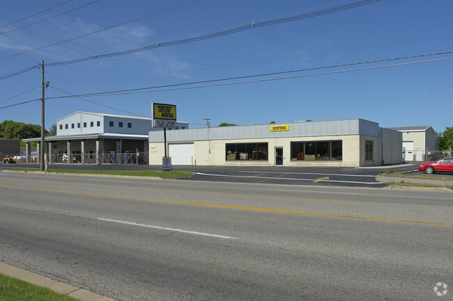
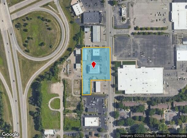
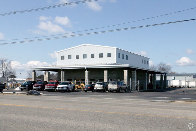
Property Record
62 S Waverly Rd, Holland, MI 49423
NEARBY LISTINGS FOR SALE OR LEASE
Property Detail
62 S Waverly Rd
Grand Rapids-Wyoming, MI
Village Of Cedar Swamp
70-16-28-299-050
PART OF LOT 4 VILLAGE OF CEDAR SWAMP COM N 0D 35M 10S W 159604 FT FROM E 1/4 COR, TH S 89D 54M W 18527 FT, S 0D 14M 25S E 130
Autorepair
Ottawa
X
Michigan
26005C0040G
4
2024
1.89 AC
2025
Holland East
025101
West Michigan
14,150 SF
DEMOGRAPHICS near 62 S Waverly Rd
1 Mile
3 Mile
5 Mile
2024 Total Population
4,723
58,225
97,574
2029 Population
4,902
60,733
101,701
Pop Growth 2024-2029
+ 3.79%
+ 4.31%
+ 4.23%
Average Age
39
38
38
2024 Total Households
1,920
21,594
36,194
HH Growth 2024-2029
+ 3.91%
+ 4.49%
+ 4.36%
Median Household Inc
$58,333
$68,310
$72,432
Avg Household Size
2.30
2.50
2.60
2024 Avg HH Vehicles
2.00
2.00
2.00
Median Home Value
$203,854
$222,093
$235,329
Median Year Built
1977
1982
1984
Nearby Places
Map Layers
Map Styles
 Street
 Aerial
- Restaurants
- Banks
- Shops
- Fitness
- Groceries
PUBLIC TRANSPORTATION
COMMUTER RAIL
Holland Amtrak Station (Pere Marquette - Amtrak)
DRIVE
WALK
Distance
Holland Amtrak Station (Pere Marquette - Amtrak)
3 min
1.5 mi
AIRPORT
Gerald R Ford International
DRIVE
WALK
Distance
Gerald R Ford International
42 min
32.6 mi
Freight Ports
Port Milwaukee
DRIVE
WALK
Distance
Port Milwaukee
278 min
237.0 mi
Nearby Properties
Address
Land Use
TOTAL SIZE
Lot Size
Zoning
Address
Land Use
TOTAL SIZE
Lot Size
Zoning
1,599,294 SF
Address
Land Use
TOTAL SIZE
Lot Size
Zoning
572,832 SF
10.89 AC
PUD
Address
Land Use
TOTAL SIZE
Lot Size
Zoning
682,378 SF
99.60 AC
NA
Address
Land Use
TOTAL SIZE
Lot Size
Zoning
662,015 SF
177 AC
SEE MAP
Address
Land Use
TOTAL SIZE
Lot Size
Zoning
377,049 SF
24.47 AC
I-2
Address
Land Use
TOTAL SIZE
Lot Size
Zoning
198,712 SF
Address
Land Use
TOTAL SIZE
Lot Size
Zoning
630,943 SF
28.50 AC
Address
Land Use
TOTAL SIZE
Lot Size
Zoning
346,440 SF
32.15 AC
PUD
Address
Land Use
TOTAL SIZE
Lot Size
Zoning
362,916 SF
19.23 AC
I-2
Address
Land Use
TOTAL SIZE
Lot Size
Zoning
391,255 SF
40.67 AC
I-2
Address
Land Use
TOTAL SIZE
Lot Size
Zoning
249,051 SF
24.77 AC
LDR
Address
Land Use
TOTAL SIZE
Lot Size
Zoning
660,002 SF
32.13 AC
I-2
Address
Land Use
TOTAL SIZE
Lot Size
Zoning
218,722 SF
8.59 AC
AGR
Address
Land Use
TOTAL SIZE
Lot Size
Zoning
320,270 SF
33.25 AC
PUD
Address
Land Use
TOTAL SIZE
Lot Size
Zoning
329,784 SF
38.51 AC
I-2
Address
Land Use
TOTAL SIZE
Lot Size
Zoning
226,347 SF
19.44 AC
I-2
Address
Land Use
TOTAL SIZE
Lot Size
Zoning
674,052 SF
79.30 AC
Address
Land Use
TOTAL SIZE
Lot Size
Zoning
132,127 SF
42.69 AC
SEE MAP
Address
Land Use
TOTAL SIZE
Lot Size
Zoning
239,465 SF
Address
Land Use
TOTAL SIZE
Lot Size
Zoning
19.20 AC
AG
Address
Land Use
TOTAL SIZE
Lot Size
Zoning
210,792 SF
22.91 AC
C-2
Address
Land Use
TOTAL SIZE
Lot Size
Zoning
94,790 SF
1.74 AC
C-2
Address
Land Use
TOTAL SIZE
Lot Size
Zoning
58,710 SF
6.96 AC
C-2
Address
Land Use
TOTAL SIZE
Lot Size
Zoning
150,822 SF
Address
Land Use
TOTAL SIZE
Lot Size
Zoning
209,455 SF
17 AC
C-2
Address
Land Use
TOTAL SIZE
Lot Size
Zoning
177,800 SF
12.34 AC
I-2
Address
Land Use
TOTAL SIZE
Lot Size
Zoning
134,490 SF
15.76 AC
C-2
Address
Land Use
TOTAL SIZE
Lot Size
Zoning
149,348 SF
9.22 AC
I-2
Address
Land Use
TOTAL SIZE
Lot Size
Zoning
136,520 SF
13.55 AC
PUD
Address
Land Use
TOTAL SIZE
Lot Size
Zoning
65.75 AC
PUD
The World's #1 Commercial Real Estate Marketplace
Connect with us
© 2025 CoStar Group
The information above has been obtained from sources believed reliable. While we do not doubt its accuracy we have not verified it and make no guarantee, warranty or representation about it. It is your responsibility to independently confirm its accuracy and completeness. Any projections, opinions, assumptions, or estimates used are for example only and do not represent the current or future performance of the property. The value of this transaction to you depends on tax and other factors which should be evaluated by your tax, financial, and legal advisors. You and your advisors should conduct a careful, independent investigation of the property to determine to your satisfaction the suitability of the property for your needs.