Property Record
62 State Route 101A, Amherst, NH 03031
NEARBY LISTINGS FOR SALE OR LEASE
Property Detail
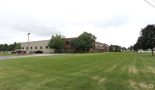
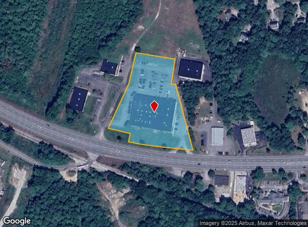
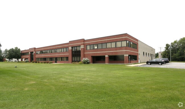
62 State Route 101A
Warehouse
Hillsborough
X
New Hampshire
33011C0487D
3.93 AC
2024
Hillsborough
2024
Boston
015200
Manchester-Nashua, NH
48,381 SF
AMHS-000002-000086
DEMOGRAPHICS near 62 State Route 101A
1 Mile
3 Mile
5 Mile
2024 Total Population
1,425
13,560
46,236
2029 Population
1,437
13,864
47,424
Pop Growth 2024-2029
+ 0.84%
+ 2.24%
+ 2.57%
Average Age
46
42
42
2024 Total Households
587
5,273
18,290
HH Growth 2024-2029
+ 0.85%
+ 2.28%
+ 2.59%
Median Household Inc
$145,172
$116,901
$114,582
Avg Household Size
2.40
2.50
2.50
2024 Avg HH Vehicles
2.00
2.00
2.00
Median Home Value
$397,352
$442,807
$410,430
Median Year Built
1978
1983
1982
Nearby Places
Map Layers
Map Styles
 Street
 Aerial
- Restaurants
- Banks
- Shops
- Fitness
- Groceries
PUBLIC TRANSPORTATION
AIRPORT
Manchester Boston Regional
DRIVE
WALK
Distance
Manchester Boston Regional
29 min
15.1 mi
Freight Ports
Port of Boston
DRIVE
WALK
Distance
Port of Boston
80 min
56.0 mi
Nearby Properties
Address
Land Use
TOTAL SIZE
Lot Size
Zoning
Address
Land Use
TOTAL SIZE
Lot Size
Zoning
259,644 SF
42.18 AC
RR
Address
Land Use
TOTAL SIZE
Lot Size
Zoning
337,000 SF
24.26 AC
PI
Address
Land Use
TOTAL SIZE
Lot Size
Zoning
360,491 SF
40.23 AC
IND
Address
Land Use
TOTAL SIZE
Lot Size
Zoning
125,916 SF
10.05 AC
GB
Address
Land Use
TOTAL SIZE
Lot Size
Zoning
227,260 SF
35 AC
PI
Address
Land Use
TOTAL SIZE
Lot Size
Zoning
307,560 SF
23 AC
PI
Address
Land Use
TOTAL SIZE
Lot Size
Zoning
200,012 SF
31.83 AC
C
Address
Land Use
TOTAL SIZE
Lot Size
Zoning
29,952 SF
12.50 AC
B
Address
Land Use
TOTAL SIZE
Lot Size
Zoning
132,836 SF
8.61 AC
GB
Address
Land Use
TOTAL SIZE
Lot Size
Zoning
44,520 SF
8.51 AC
PI
Address
Land Use
TOTAL SIZE
Lot Size
Zoning
128,215 SF
13.55 AC
GB
Address
Land Use
TOTAL SIZE
Lot Size
Zoning
19,968 SF
5.91 AC
B
Address
Land Use
TOTAL SIZE
Lot Size
Zoning
67,994 SF
8.60 AC
PI
Address
Land Use
TOTAL SIZE
Lot Size
Zoning
16.10 AC
PI
Address
Land Use
TOTAL SIZE
Lot Size
Zoning
34,844 SF
15.89 AC
GB
Address
Land Use
TOTAL SIZE
Lot Size
Zoning
15,616 SF
6.06 AC
B
Address
Land Use
TOTAL SIZE
Lot Size
Zoning
132,637 SF
14.16 AC
C
Address
Land Use
TOTAL SIZE
Lot Size
Zoning
64,589 SF
26.11 AC
RR11
Address
Land Use
TOTAL SIZE
Lot Size
Zoning
181,590 SF
12.79 AC
ICI
Address
Land Use
TOTAL SIZE
Lot Size
Zoning
150,052 SF
10.50 AC
PI
Address
Land Use
TOTAL SIZE
Lot Size
Zoning
131,191 SF
51.10 AC
C2- GE
Address
Land Use
TOTAL SIZE
Lot Size
Zoning
110,892 SF
18.38 AC
C2- GE
Address
Land Use
TOTAL SIZE
Lot Size
Zoning
72,384 SF
6.26 AC
A
Address
Land Use
TOTAL SIZE
Lot Size
Zoning
70,612 SF
6.42 AC
C
Address
Land Use
TOTAL SIZE
Lot Size
Zoning
4.19 AC
IND
Address
Land Use
TOTAL SIZE
Lot Size
Zoning
66,088 SF
12.48 AC
ICI
Address
Land Use
TOTAL SIZE
Lot Size
Zoning
91,234 SF
8.92 AC
C
Address
Land Use
TOTAL SIZE
Lot Size
Zoning
23,040 SF
4.57 AC
LC
Address
Land Use
TOTAL SIZE
Lot Size
Zoning
75,400 SF
12.46 AC
PI
Address
Land Use
TOTAL SIZE
Lot Size
Zoning
55,580 SF
8.68 AC
PI
The World's #1 Commercial Real Estate Marketplace
Connect with us
© 2026 CoStar Group
The information above has been obtained from sources believed reliable. While we do not doubt its accuracy we have not verified it and make no guarantee, warranty or representation about it. It is your responsibility to independently confirm its accuracy and completeness. Any projections, opinions, assumptions, or estimates used are for example only and do not represent the current or future performance of the property. The value of this transaction to you depends on tax and other factors which should be evaluated by your tax, financial, and legal advisors. You and your advisors should conduct a careful, independent investigation of the property to determine to your satisfaction the suitability of the property for your needs.