Property Record
620 1St St, Hershey, NE 69143
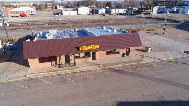

This Property Is For Sale
Property Detail
620 1St St
North Platte, NE
WATER CO. ADD. VAC. PORTION OF GRANT AVE. A; MAP NUMBER: 2873-00-0-00000-000-9475
0079475.00
LINCOLN
Taxexempt
Nebraska
B and X Area of moderate flood hazard, usually the area between the limits of the 100-year and 500-year floods.
0.13 AC
0
I-80 Corridor
2025
Other Market Areas
959800
NEARBY LISTINGS FOR SALE OR LEASE
-
-
View all Hershey listings for sale on LoopNet.com
DEMOGRAPHICS near 620 1St St
1 mile
3 mile
5 mile
2025 Total Population
630
962
1,296
2030 Population
606
933
1,261
Pop Growth 2025-2030
(3.81%)
(3.01%)
(2.70%)
Average Age
42
42
43
2025 Total Households
265
403
539
HH Growth 2025-2030
(3.77%)
(3.23%)
(2.78%)
Median Household Inc
$71,666
$73,943
$74,662
Avg Household Size
2.40
2.40
2.40
2025 Avg HH Vehicles
2.00
3.00
3.00
Median Home Value
$246,250
$247,142
$246,464
Median Year Built
1968
1969
1969
Nearby Places
Map Layers
Map Styles
 Street
 Aerial
Layers
 Traffic
 Biking
Places
Listings with unknown addresses are not visible on the map
- Restaurants
- Banks
- Shops
- Fitness
- Groceries
Nearby Properties
Address
Land Use
TOTAL SIZE
Lot Size
Zoning
Address
Land Use
TOTAL SIZE
Lot Size
Zoning
53,000 SF
34.28 AC
COMMERCIAL
Address
Land Use
TOTAL SIZE
Lot Size
Zoning
4,800 SF
8.28 AC
COMMERCIAL
Address
Land Use
TOTAL SIZE
Lot Size
Zoning
320 AC
AGRICULTUR
Address
Land Use
TOTAL SIZE
Lot Size
Zoning
168 SF
156.85 AC
AGRICULTUR
Address
Land Use
TOTAL SIZE
Lot Size
Zoning
10,668 SF
9.29 AC
COMMERCIAL
Address
Land Use
TOTAL SIZE
Lot Size
Zoning
245.19 AC
AGRICULTUR
Address
Land Use
TOTAL SIZE
Lot Size
Zoning
149.54 AC
AGRICULTUR
Address
Land Use
TOTAL SIZE
Lot Size
Zoning
150.92 AC
AGRICULTUR
Address
Land Use
TOTAL SIZE
Lot Size
Zoning
150.10 AC
AGRICULTUR
Address
Land Use
TOTAL SIZE
Lot Size
Zoning
1,200 SF
160 AC
AGRICULTUR
Address
Land Use
TOTAL SIZE
Lot Size
Zoning
160 AC
AGRICULTUR
Address
Land Use
TOTAL SIZE
Lot Size
Zoning
160.69 AC
AGRICULTUR
Address
Land Use
TOTAL SIZE
Lot Size
Zoning
139.36 AC
AGRICULTUR
Address
Land Use
TOTAL SIZE
Lot Size
Zoning
142.31 AC
AGRICULTUR
Address
Land Use
TOTAL SIZE
Lot Size
Zoning
113.77 AC
AGRICULTUR
Address
Land Use
TOTAL SIZE
Lot Size
Zoning
2,499 SF
120 AC
AGRICULTUR
Address
Land Use
TOTAL SIZE
Lot Size
Zoning
7,592 SF
0.21 AC
COMMERCIAL
Address
Land Use
TOTAL SIZE
Lot Size
Zoning
120 AC
AGRICULTUR
Address
Land Use
TOTAL SIZE
Lot Size
Zoning
120 AC
AGRICULTUR
Address
Land Use
TOTAL SIZE
Lot Size
Zoning
80 AC
AGRICULTUR
Address
Land Use
TOTAL SIZE
Lot Size
Zoning
69.15 AC
AGRICULTUR
Address
Land Use
TOTAL SIZE
Lot Size
Zoning
1,290 SF
67.18 AC
AGRICULTUR
Address
Land Use
TOTAL SIZE
Lot Size
Zoning
79 AC
AGRICULTUR
Address
Land Use
TOTAL SIZE
Lot Size
Zoning
160 AC
AGRICULTUR
Address
Land Use
TOTAL SIZE
Lot Size
Zoning
160 AC
AGRICULTUR
Address
Land Use
TOTAL SIZE
Lot Size
Zoning
768 SF
3.38 AC
COMMERCIAL
Address
Land Use
TOTAL SIZE
Lot Size
Zoning
672 SF
53.71 AC
SINGLE-FAM
Address
Land Use
TOTAL SIZE
Lot Size
Zoning
667 SF
140.75 AC
AGRICULTUR
Address
Land Use
TOTAL SIZE
Lot Size
Zoning
60 AC
AGRICULTUR
Address
Land Use
TOTAL SIZE
Lot Size
Zoning
79 AC
AGRICULTUR
The World's #1 Commercial Real Estate Marketplace
Connect with us
© 2026 CoStar Group
The information above has been obtained from sources believed reliable. While we do not doubt its accuracy we have not verified it and make no guarantee, warranty or representation about it. It is your responsibility to independently confirm its accuracy and completeness. Any projections, opinions, assumptions, or estimates used are for example only and do not represent the current or future performance of the property. The value of this transaction to you depends on tax and other factors which should be evaluated by your tax, financial, and legal advisors. You and your advisors should conduct a careful, independent investigation of the property to determine to your satisfaction the suitability of the property for your needs.