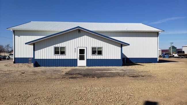
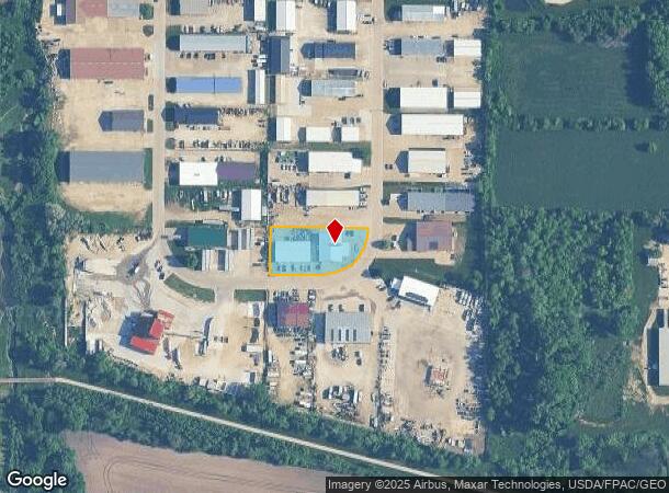
Property Record
620 51St St, Marion, IA 52302

NEARBY LISTINGS FOR SALE OR LEASE
-
-
View all Marion listings for lease on LoopNet.com
Property Detail
620 51St St
Cedar Rapids, IA
Foxs 1St
15042-29014-00000
FOXS 1ST LOT 8
Miningfacilityoilgasmineralpreciousmetals
Linn
X
Iowa
19113C0318E
8
2024
2.04 AC
2025
Iowa City/Waterloo
000103
Other Market Areas
13,268 SF
DEMOGRAPHICS near 620 51St St
1 Mile
3 Mile
5 Mile
2024 Total Population
5,256
31,767
69,644
2029 Population
5,294
31,511
69,284
Pop Growth 2024-2029
+ 0.72%
(0.81%)
(0.52%)
Average Age
40
41
41
2024 Total Households
2,141
13,243
29,169
HH Growth 2024-2029
+ 0.61%
(0.82%)
(0.56%)
Median Household Inc
$65,392
$70,876
$72,220
Avg Household Size
2.40
2.30
2.30
2024 Avg HH Vehicles
2.00
2.00
2.00
Median Home Value
$168,230
$190,600
$198,360
Median Year Built
1996
1986
1980
Nearby Places
Map Layers
Map Styles
 Street
 Aerial
- Restaurants
- Banks
- Shops
- Fitness
- Groceries
PUBLIC TRANSPORTATION
AIRPORT
The Eastern Iowa
DRIVE
WALK
Distance
The Eastern Iowa
30 min
20.9 mi
Freight Ports
Port Milwaukee
DRIVE
WALK
Distance
Port Milwaukee
280 min
237.3 mi
SALE & LEASE HISTORY
LISTING DATE
SALE/LEASE

Mar 11, 2020
For Lease
Nearby Properties
Address
Land Use
TOTAL SIZE
Lot Size
Zoning
Address
Land Use
TOTAL SIZE
Lot Size
Zoning
4,413,839 SF
3,841.80 AC
Address
Land Use
TOTAL SIZE
Lot Size
Zoning
585,444 SF
95.41 AC
Address
Land Use
TOTAL SIZE
Lot Size
Zoning
980,058 SF
107.75 AC
Address
Land Use
TOTAL SIZE
Lot Size
Zoning
180,790 SF
24.39 AC
Address
Land Use
TOTAL SIZE
Lot Size
Zoning
22,809 SF
21.48 AC
Address
Land Use
TOTAL SIZE
Lot Size
Zoning
203,166 SF
14.16 AC
Address
Land Use
TOTAL SIZE
Lot Size
Zoning
106,317 SF
8.84 AC
Address
Land Use
TOTAL SIZE
Lot Size
Zoning
155,200 SF
32.40 AC
Address
Land Use
TOTAL SIZE
Lot Size
Zoning
50,344 SF
2.92 AC
Address
Land Use
TOTAL SIZE
Lot Size
Zoning
218,390 SF
50.24 AC
Address
Land Use
TOTAL SIZE
Lot Size
Zoning
155,200 SF
28.66 AC
Address
Land Use
TOTAL SIZE
Lot Size
Zoning
155,185 SF
171 AC
AG
Address
Land Use
TOTAL SIZE
Lot Size
Zoning
1,472,473 SF
395.89 AC
Address
Land Use
TOTAL SIZE
Lot Size
Zoning
154,687 SF
59.08 AC
Address
Land Use
TOTAL SIZE
Lot Size
Zoning
1,440 SF
82.59 AC
Address
Land Use
TOTAL SIZE
Lot Size
Zoning
92,704 SF
10.30 AC
Address
Land Use
TOTAL SIZE
Lot Size
Zoning
20,870 SF
28 AC
Address
Land Use
TOTAL SIZE
Lot Size
Zoning
195,744 SF
4.44 AC
Address
Land Use
TOTAL SIZE
Lot Size
Zoning
202,224 SF
81.20 AC
Address
Land Use
TOTAL SIZE
Lot Size
Zoning
202,224 SF
102.24 AC
Address
Land Use
TOTAL SIZE
Lot Size
Zoning
202,653 SF
35.12 AC
Address
Land Use
TOTAL SIZE
Lot Size
Zoning
22,068 SF
5.06 AC
Address
Land Use
TOTAL SIZE
Lot Size
Zoning
29,960 SF
45 AC
Address
Land Use
TOTAL SIZE
Lot Size
Zoning
53,994 SF
4.40 AC
Address
Land Use
TOTAL SIZE
Lot Size
Zoning
57,277 SF
6.78 AC
Address
Land Use
TOTAL SIZE
Lot Size
Zoning
110,746 SF
8.72 AC
Address
Land Use
TOTAL SIZE
Lot Size
Zoning
808,173 SF
91.74 AC
Address
Land Use
TOTAL SIZE
Lot Size
Zoning
20,710 SF
4.96 AC
Address
Land Use
TOTAL SIZE
Lot Size
Zoning
3,960 SF
5.58 AC
Address
Land Use
TOTAL SIZE
Lot Size
Zoning
52,141 SF
5.98 AC
The World's #1 Commercial Real Estate Marketplace
Connect with us
© 2025 CoStar Group
The information above has been obtained from sources believed reliable. While we do not doubt its accuracy we have not verified it and make no guarantee, warranty or representation about it. It is your responsibility to independently confirm its accuracy and completeness. Any projections, opinions, assumptions, or estimates used are for example only and do not represent the current or future performance of the property. The value of this transaction to you depends on tax and other factors which should be evaluated by your tax, financial, and legal advisors. You and your advisors should conduct a careful, independent investigation of the property to determine to your satisfaction the suitability of the property for your needs.