Property Record
620 6Th St, Braddock, PA 15104
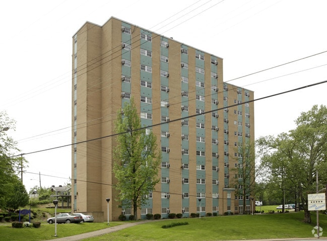

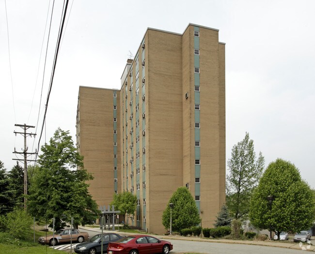
Property Detail
620 6Th St
Pittsburgh, PA
COALMONT PLAN PURPT 5 0.92 ACRES LD 6TH ST
0301-N-00166-0000-00
Allegheny
Countyproperty
Pennsylvania
B and X Area of moderate flood hazard, usually the area between the limits of the 100-year and 500-year floods.
166
2023
0.92 AC
2025
Braddock
513000
Pittsburgh
NEARBY LISTINGS FOR SALE OR LEASE
-
-
-
-
-
-
No Photo
-
-
View all Braddock listings for sale on LoopNet.com
DEMOGRAPHICS near 620 6Th St
1 mile
3 mile
5 mile
2025 Total Population
8,528
92,988
247,247
2030 Population
8,631
92,732
246,656
Pop Growth 2025-2030
+ 1.21%
(0.28%)
(0.24%)
Average Age
40
43
42
2025 Total Households
4,035
44,881
114,197
HH Growth 2025-2030
+ 1.14%
(0.32%)
(0.34%)
Median Household Inc
$33,649
$55,635
$58,511
Avg Household Size
2.00
2.00
2.10
2025 Avg HH Vehicles
1.00
1.00
1.00
Median Home Value
$77,977
$147,275
$156,056
Median Year Built
1949
1950
1951
Nearby Places
Map Layers
Map Styles
 Street
 Aerial
Transit
 Traffic
 Biking
Places
Listings with unknown addresses are not visible on the map
- Restaurants
- Banks
- Shops
- Fitness
- Groceries
PUBLIC TRANSPORTATION
COMMUTER RAIL
Pittsburgh Amtrak Station (Capitol Limited - Amtrak, Pennsylvanian - Amtrak)
Drive
Walk
Distance
Pittsburgh Amtrak Station (Capitol Limited - Amtrak, Pennsylvanian - Amtrak)
16 min
9.0 mi
AIRPORT
Pittsburgh International
Drive
Walk
Distance
Pittsburgh International
39 min
25.5 mi
Arnold Palmer Regional
Drive
Walk
Distance
Arnold Palmer Regional
56 min
29.6 mi
Freight Ports
Port of Baltimore
Drive
Walk
Distance
Port of Baltimore
283 min
235.3 mi
Nearby Properties
Address
Land Use
TOTAL SIZE
Lot Size
Zoning
Address
Land Use
TOTAL SIZE
Lot Size
Zoning
42.65 AC
Address
Land Use
TOTAL SIZE
Lot Size
Zoning
Address
Land Use
TOTAL SIZE
Lot Size
Zoning
Address
Land Use
TOTAL SIZE
Lot Size
Zoning
23.87 AC
Address
Land Use
TOTAL SIZE
Lot Size
Zoning
Address
Land Use
TOTAL SIZE
Lot Size
Zoning
1.39 AC
Address
Land Use
TOTAL SIZE
Lot Size
Zoning
2.92 AC
Address
Land Use
TOTAL SIZE
Lot Size
Zoning
19.85 AC
Address
Land Use
TOTAL SIZE
Lot Size
Zoning
121.64 AC
Address
Land Use
TOTAL SIZE
Lot Size
Zoning
Address
Land Use
TOTAL SIZE
Lot Size
Zoning
Address
Land Use
TOTAL SIZE
Lot Size
Zoning
17.52 AC
Address
Land Use
TOTAL SIZE
Lot Size
Zoning
19.54 AC
Address
Land Use
TOTAL SIZE
Lot Size
Zoning
10.93 AC
Address
Land Use
TOTAL SIZE
Lot Size
Zoning
1.48 AC
Address
Land Use
TOTAL SIZE
Lot Size
Zoning
3.54 AC
Address
Land Use
TOTAL SIZE
Lot Size
Zoning
24.63 AC
Address
Land Use
TOTAL SIZE
Lot Size
Zoning
Address
Land Use
TOTAL SIZE
Lot Size
Zoning
Address
Land Use
TOTAL SIZE
Lot Size
Zoning
Address
Land Use
TOTAL SIZE
Lot Size
Zoning
18.09 AC
Address
Land Use
TOTAL SIZE
Lot Size
Zoning
Address
Land Use
TOTAL SIZE
Lot Size
Zoning
Address
Land Use
TOTAL SIZE
Lot Size
Zoning
Address
Land Use
TOTAL SIZE
Lot Size
Zoning
66.40 AC
Address
Land Use
TOTAL SIZE
Lot Size
Zoning
Address
Land Use
TOTAL SIZE
Lot Size
Zoning
10.13 AC
Address
Land Use
TOTAL SIZE
Lot Size
Zoning
1.51 AC
Address
Land Use
TOTAL SIZE
Lot Size
Zoning
1.65 AC
The World's #1 Commercial Real Estate Marketplace
Connect with us
© 2026 CoStar Group
The information above has been obtained from sources believed reliable. While we do not doubt its accuracy we have not verified it and make no guarantee, warranty or representation about it. It is your responsibility to independently confirm its accuracy and completeness. Any projections, opinions, assumptions, or estimates used are for example only and do not represent the current or future performance of the property. The value of this transaction to you depends on tax and other factors which should be evaluated by your tax, financial, and legal advisors. You and your advisors should conduct a careful, independent investigation of the property to determine to your satisfaction the suitability of the property for your needs.