Property Record
620 E 4Th St, Monroe, MI 48161
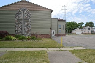

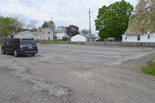
Property Detail
620 E 4Th St
Monroe, MI
ISADORE NAVARRE FARM E 16 FT OF N 142 FT OF LOT 82 AND W 70 FT OF N 142 FT OF LOT 83
55-49-00760-000
Monroe
Commercialnec
Michigan
R-1A
82-83
B and X Area of moderate flood hazard, usually the area between the limits of the 100-year and 500-year floods.
0.28 AC
0
Monroe County
2025
Detroit
832000
NEARBY LISTINGS FOR SALE OR LEASE
-
-
View all Monroe listings for sale on LoopNet.com
DEMOGRAPHICS near 620 E 4Th St
1 mile
3 mile
5 mile
2025 Total Population
10,992
37,691
52,396
2030 Population
11,045
37,700
52,612
Pop Growth 2025-2030
+ 0.48%
+ 0.02%
+ 0.41%
Average Age
39
42
42
2025 Total Households
4,262
15,666
21,494
HH Growth 2025-2030
+ 0.49%
(0.02%)
+ 0.38%
Median Household Inc
$54,346
$56,666
$64,117
Avg Household Size
2.30
2.30
2.30
2025 Avg HH Vehicles
2.00
2.00
2.00
Median Home Value
$148,576
$174,822
$193,143
Median Year Built
1947
1964
1967
Nearby Places
Map Layers
Map Styles
 Street
 Aerial
Layers
 Traffic
 Biking
Places
Listings with unknown addresses are not visible on the map
- Restaurants
- Banks
- Shops
- Fitness
- Groceries
PUBLIC TRANSPORTATION
AIRPORT
Detroit Metro Wayne County
Drive
Walk
Distance
Detroit Metro Wayne County
34 min
24.2 mi
Freight Ports
Port of Toledo
Drive
Walk
Distance
Port of Toledo
36 min
23.5 mi
SALE & LEASE HISTORY
LISTING DATE
SALE/LEASE

Jan 20, 2017
For Sale
Nearby Properties
Address
Land Use
TOTAL SIZE
Lot Size
Zoning
Address
Land Use
TOTAL SIZE
Lot Size
Zoning
97.18 AC
Address
Land Use
TOTAL SIZE
Lot Size
Zoning
5,088 SF
123.61 AC
R-1A
Address
Land Use
TOTAL SIZE
Lot Size
Zoning
48,845 SF
163.20 AC
R-1A
Address
Land Use
TOTAL SIZE
Lot Size
Zoning
200,000 SF
94.63 AC
CO
Address
Land Use
TOTAL SIZE
Lot Size
Zoning
409,765 SF
41.46 AC
Address
Land Use
TOTAL SIZE
Lot Size
Zoning
95.60 AC
Address
Land Use
TOTAL SIZE
Lot Size
Zoning
Address
Land Use
TOTAL SIZE
Lot Size
Zoning
195,744 SF
32.62 AC
C-2-COMMER
Address
Land Use
TOTAL SIZE
Lot Size
Zoning
109,073 SF
47.32 AC
Address
Land Use
TOTAL SIZE
Lot Size
Zoning
Address
Land Use
TOTAL SIZE
Lot Size
Zoning
183,508 SF
70 AC
Address
Land Use
TOTAL SIZE
Lot Size
Zoning
315,000 SF
24.47 AC
Address
Land Use
TOTAL SIZE
Lot Size
Zoning
3.97 AC
Address
Land Use
TOTAL SIZE
Lot Size
Zoning
13.60 AC
Address
Land Use
TOTAL SIZE
Lot Size
Zoning
108,575 SF
38.21 AC
R-1A
Address
Land Use
TOTAL SIZE
Lot Size
Zoning
43,528 SF
16.06 AC
MHP
Address
Land Use
TOTAL SIZE
Lot Size
Zoning
507.34 AC
R-1A
Address
Land Use
TOTAL SIZE
Lot Size
Zoning
317,482 SF
20.53 AC
Address
Land Use
TOTAL SIZE
Lot Size
Zoning
134,464 SF
34.35 AC
Address
Land Use
TOTAL SIZE
Lot Size
Zoning
2,195 SF
86.71 AC
MHP
Address
Land Use
TOTAL SIZE
Lot Size
Zoning
192,917 SF
15.81 AC
R3B-MULTIF
Address
Land Use
TOTAL SIZE
Lot Size
Zoning
69,590 SF
11.55 AC
C-2-COMMER
Address
Land Use
TOTAL SIZE
Lot Size
Zoning
148,343 SF
15.15 AC
Address
Land Use
TOTAL SIZE
Lot Size
Zoning
3,822 SF
16.60 AC
R-1A
Address
Land Use
TOTAL SIZE
Lot Size
Zoning
Address
Land Use
TOTAL SIZE
Lot Size
Zoning
189,314 SF
28.56 AC
Address
Land Use
TOTAL SIZE
Lot Size
Zoning
94,324 SF
10.11 AC
Address
Land Use
TOTAL SIZE
Lot Size
Zoning
62,459 SF
2.59 AC
Address
Land Use
TOTAL SIZE
Lot Size
Zoning
41 AC
MHP
Address
Land Use
TOTAL SIZE
Lot Size
Zoning
412,877 SF
22.35 AC
R-1A
The World's #1 Commercial Real Estate Marketplace
Connect with us
© 2026 CoStar Group
The information above has been obtained from sources believed reliable. While we do not doubt its accuracy we have not verified it and make no guarantee, warranty or representation about it. It is your responsibility to independently confirm its accuracy and completeness. Any projections, opinions, assumptions, or estimates used are for example only and do not represent the current or future performance of the property. The value of this transaction to you depends on tax and other factors which should be evaluated by your tax, financial, and legal advisors. You and your advisors should conduct a careful, independent investigation of the property to determine to your satisfaction the suitability of the property for your needs.