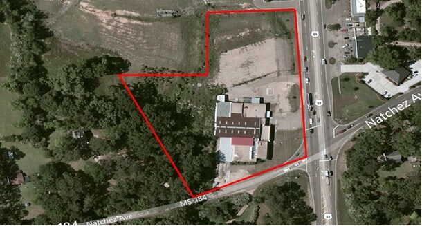
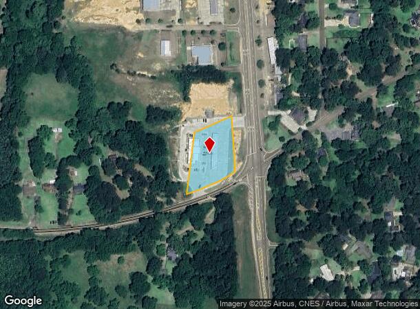
Property Record
620 Highway 51 S, Brookhaven, MS 39601
NEARBY LISTINGS FOR SALE OR LEASE
-
-
View all Brookhaven listings for sale on LoopNet.com
Property Detail
620 Highway 51 S
B77-13-3-017
Section 13-7-7
Storebuilding
BEG AT INTERSEC OF HW 84 & HW 51, RUN W 200', N 318', E 200', S 315' TO BEG, BEING IN SE1/4 OF SW1/4 SECTION 13-7-7 0140
X
Lincoln
28085C0179D
Mississippi
2025
1.45 AC
2024
Hattiesburg/South Area
950601
Other Market Areas
6,218 SF
Brookhaven, MS
DEMOGRAPHICS near 620 Highway 51 S
1 Mile
3 Mile
5 Mile
2024 Total Population
3,459
11,734
16,891
2029 Population
3,443
11,643
16,707
Pop Growth 2024-2029
(0.46%)
(0.78%)
(1.09%)
Average Age
42
40
41
2024 Total Households
1,484
4,772
6,837
HH Growth 2024-2029
(0.34%)
(0.73%)
(1.04%)
Median Household Inc
$44,814
$35,778
$38,683
Avg Household Size
2.30
2.30
2.40
2024 Avg HH Vehicles
2.00
2.00
2.00
Median Home Value
$139,749
$95,345
$105,657
Median Year Built
1973
1975
1978
Nearby Places
Map Layers
Map Styles
 Street
 Aerial
- Restaurants
- Banks
- Shops
- Fitness
- Groceries
PUBLIC TRANSPORTATION
COMMUTER RAIL
Brookhaven Amtrak Station (City of New Orleans - Amtrak)
DRIVE
WALK
Distance
Brookhaven Amtrak Station (City of New Orleans - Amtrak)
4 min
1.9 mi
Freight Ports
Port of Greater Baton Rouge
DRIVE
WALK
Distance
Port of Greater Baton Rouge
139 min
122.7 mi
SALE & LEASE HISTORY
LISTING DATE
SALE/LEASE

Sep 24, 2016
For Sale
Mar 20, 2017
For Sale
Feb 09, 2017
For Sale
Feb 09, 2017
For Sale
Nearby Properties
Address
Land Use
TOTAL SIZE
Lot Size
Zoning
Address
Land Use
TOTAL SIZE
Lot Size
Zoning
56,350 SF
12 AC
Address
Land Use
TOTAL SIZE
Lot Size
Zoning
8.21 AC
Address
Land Use
TOTAL SIZE
Lot Size
Zoning
200,176 SF
24.52 AC
Address
Land Use
TOTAL SIZE
Lot Size
Zoning
4,965 SF
19.24 AC
Address
Land Use
TOTAL SIZE
Lot Size
Zoning
9,487 SF
0.67 AC
Address
Land Use
TOTAL SIZE
Lot Size
Zoning
6,066 SF
1.83 AC
Address
Land Use
TOTAL SIZE
Lot Size
Zoning
6,800 SF
0.79 AC
Address
Land Use
TOTAL SIZE
Lot Size
Zoning
8,334 SF
0.87 AC
Address
Land Use
TOTAL SIZE
Lot Size
Zoning
15,968 SF
52.20 AC
Address
Land Use
TOTAL SIZE
Lot Size
Zoning
10,202 SF
0.23 AC
Address
Land Use
TOTAL SIZE
Lot Size
Zoning
80,976 SF
10.90 AC
Address
Land Use
TOTAL SIZE
Lot Size
Zoning
5,907 SF
4 AC
Address
Land Use
TOTAL SIZE
Lot Size
Zoning
8,000 SF
4.10 AC
Address
Land Use
TOTAL SIZE
Lot Size
Zoning
46,353 SF
4.06 AC
Address
Land Use
TOTAL SIZE
Lot Size
Zoning
35,283 SF
4.08 AC
Address
Land Use
TOTAL SIZE
Lot Size
Zoning
2,040 SF
15 AC
Address
Land Use
TOTAL SIZE
Lot Size
Zoning
38,528 SF
6.47 AC
Address
Land Use
TOTAL SIZE
Lot Size
Zoning
2,210 SF
10.98 AC
Address
Land Use
TOTAL SIZE
Lot Size
Zoning
31,491 SF
2.50 AC
Address
Land Use
TOTAL SIZE
Lot Size
Zoning
36,262 SF
4.13 AC
Address
Land Use
TOTAL SIZE
Lot Size
Zoning
7,644 SF
1.40 AC
Address
Land Use
TOTAL SIZE
Lot Size
Zoning
5.85 AC
Address
Land Use
TOTAL SIZE
Lot Size
Zoning
18,493 SF
46.96 AC
Address
Land Use
TOTAL SIZE
Lot Size
Zoning
0.25 AC
Address
Land Use
TOTAL SIZE
Lot Size
Zoning
8,536 SF
6.50 AC
Address
Land Use
TOTAL SIZE
Lot Size
Zoning
32,537 SF
4.45 AC
Address
Land Use
TOTAL SIZE
Lot Size
Zoning
4,373 SF
1.36 AC
Address
Land Use
TOTAL SIZE
Lot Size
Zoning
9,865 SF
0.55 AC
Address
Land Use
TOTAL SIZE
Lot Size
Zoning
15,747 SF
6.89 AC
Address
Land Use
TOTAL SIZE
Lot Size
Zoning
7,248 SF
0.59 AC
The World's #1 Commercial Real Estate Marketplace
Connect with us
© 2026 CoStar Group
The information above has been obtained from sources believed reliable. While we do not doubt its accuracy we have not verified it and make no guarantee, warranty or representation about it. It is your responsibility to independently confirm its accuracy and completeness. Any projections, opinions, assumptions, or estimates used are for example only and do not represent the current or future performance of the property. The value of this transaction to you depends on tax and other factors which should be evaluated by your tax, financial, and legal advisors. You and your advisors should conduct a careful, independent investigation of the property to determine to your satisfaction the suitability of the property for your needs.