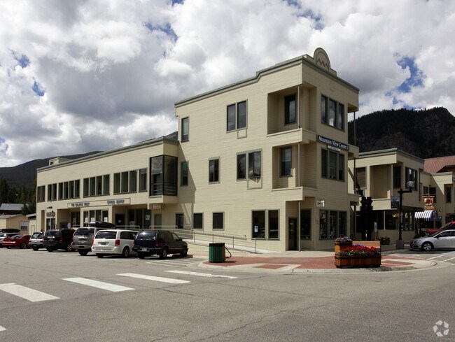
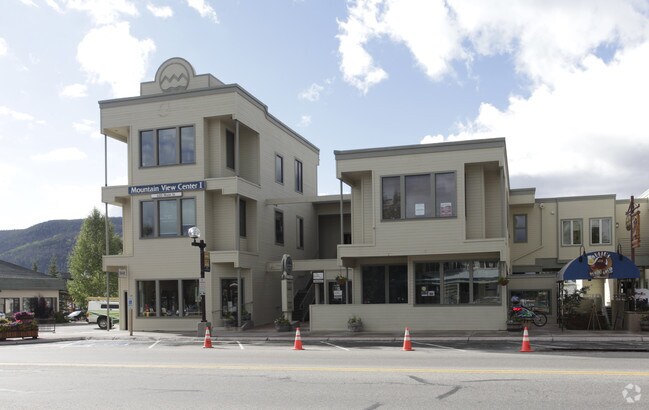
Property Record
620 Main St, Frisco, CO 80443

Save to a Folder
{{folder.Name}}
{{folder.ListingIds.length}} Properties
{{folder.ListingIds.length}} Property
Create a New Folder
Property Detail
620 Main St
Breckenridge, CO
IN MOUNTAIN VIEW CENTER AMENDED COMMON AREA
6513892
SUMMIT
Residentialacreage
Colorado
CC
area
B and X Area of moderate flood hazard, usually the area between the limits of the 100-year and 500-year floods.
0.32 AC
0
Colorado Ski Area
2025
Other Market Areas
000302
NEARBY LISTINGS FOR SALE OR LEASE
DEMOGRAPHICS near 620 Main St
1 mile
3 mile
5 mile
2025 Total Population
3,289
5,288
15,228
2030 Population
3,153
5,154
15,007
Pop Growth 2025-2030
(4.13%)
(2.53%)
(1.45%)
Average Age
42
41
40
2025 Total Households
1,392
2,293
6,233
HH Growth 2025-2030
(5.17%)
(3.01%)
(1.57%)
Median Household Inc
$114,417
$117,156
$117,207
Avg Household Size
2.00
2.10
2.30
2025 Avg HH Vehicles
2.00
2.00
2.00
Median Home Value
$868,804
$909,982
$901,728
Median Year Built
1985
1987
1990
Nearby Places
Map Layers
Map Styles
 Street
 Aerial
Layers
 Traffic
 Biking
Places
Listings with unknown addresses are not visible on the map
- Restaurants
- Banks
- Shops
- Fitness
- Groceries
Nearby Properties
Address
Land Use
TOTAL SIZE
Lot Size
Zoning
Address
Land Use
TOTAL SIZE
Lot Size
Zoning
54,915 SF
1.98 AC
PUD
Address
Land Use
TOTAL SIZE
Lot Size
Zoning
31,068 SF
3.79 AC
Address
Land Use
TOTAL SIZE
Lot Size
Zoning
83,981 SF
2.99 AC
FGW
Address
Land Use
TOTAL SIZE
Lot Size
Zoning
32,423 SF
FGW
Address
Land Use
TOTAL SIZE
Lot Size
Zoning
22,910 SF
0.83 AC
MU
Address
Land Use
TOTAL SIZE
Lot Size
Zoning
74,964 SF
5.60 AC
CO
Address
Land Use
TOTAL SIZE
Lot Size
Zoning
127,470 SF
4.43 AC
FGW
Address
Land Use
TOTAL SIZE
Lot Size
Zoning
4,932 SF
0.56 AC
CC
Address
Land Use
TOTAL SIZE
Lot Size
Zoning
15,620 SF
1.60 AC
CO
Address
Land Use
TOTAL SIZE
Lot Size
Zoning
14,403 SF
FGW
Address
Land Use
TOTAL SIZE
Lot Size
Zoning
21,894 SF
FGW
Address
Land Use
TOTAL SIZE
Lot Size
Zoning
3,533 SF
0.07 AC
CC
Address
Land Use
TOTAL SIZE
Lot Size
Zoning
10,412 SF
11.54 AC
PUD
Address
Land Use
TOTAL SIZE
Lot Size
Zoning
1 AC
MU
Address
Land Use
TOTAL SIZE
Lot Size
Zoning
15,441 SF
1.07 AC
PUD
Address
Land Use
TOTAL SIZE
Lot Size
Zoning
20,200 SF
1.29 AC
PUD
Address
Land Use
TOTAL SIZE
Lot Size
Zoning
9,896 SF
4.05 AC
PUD
Address
Land Use
TOTAL SIZE
Lot Size
Zoning
3.80 AC
FLI
Address
Land Use
TOTAL SIZE
Lot Size
Zoning
2,460 SF
2.48 AC
FLI
Address
Land Use
TOTAL SIZE
Lot Size
Zoning
46,899 SF
2.72 AC
CO
Address
Land Use
TOTAL SIZE
Lot Size
Zoning
8,547 SF
4.05 AC
PUD
Address
Land Use
TOTAL SIZE
Lot Size
Zoning
15,402 SF
FGW
Address
Land Use
TOTAL SIZE
Lot Size
Zoning
20,402 SF
0.94 AC
FLI
Address
Land Use
TOTAL SIZE
Lot Size
Zoning
8,875 SF
FGW
Address
Land Use
TOTAL SIZE
Lot Size
Zoning
13,226 SF
0.32 AC
CC
Address
Land Use
TOTAL SIZE
Lot Size
Zoning
7,501 SF
0.95 AC
PUD
Address
Land Use
TOTAL SIZE
Lot Size
Zoning
1,865 SF
0.03 AC
PUD
Address
Land Use
TOTAL SIZE
Lot Size
Zoning
15,634 SF
0.48 AC
CC
Address
Land Use
TOTAL SIZE
Lot Size
Zoning
967 SF
0.24 AC
RH
Address
Land Use
TOTAL SIZE
Lot Size
Zoning
5,203 SF
1.02 AC
FGW
The World's #1 Commercial Real Estate Marketplace
Connect with us
© 2026 CoStar Group
The information above has been obtained from sources believed reliable. While we do not doubt its accuracy we have not verified it and make no guarantee, warranty or representation about it. It is your responsibility to independently confirm its accuracy and completeness. Any projections, opinions, assumptions, or estimates used are for example only and do not represent the current or future performance of the property. The value of this transaction to you depends on tax and other factors which should be evaluated by your tax, financial, and legal advisors. You and your advisors should conduct a careful, independent investigation of the property to determine to your satisfaction the suitability of the property for your needs.