Property Record
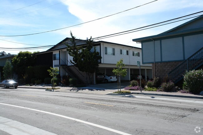
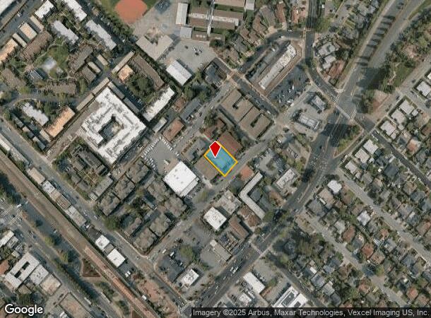
620 Masonic Way, Belmont, CA 94002
This Property Is For Sale
NEARBY LISTINGS FOR SALE OR LEASE
Property Detail
620 Masonic Way
San Francisco-Redwood City-South San Francisco, CA
Sterling Downs Unit No 2A
040-312-160
ON NWLY LN OF MASONIC WAY COM 83.63 FT SWLY FR LOT 3 BLK 2 OF STERLING DOWNS UNIT NO 2A ACREAGE CITY OF BELMONT
Multifamilydwelling
San Mateo
X
California
06081C0169G
3
2024
0.23 AC
2025
Belmont
608600
San Francisco
9,233 SF
DEMOGRAPHICS near 620 Masonic Way
1 Mile
3 Mile
5 Mile
2024 Total Population
17,252
146,816
276,457
2029 Population
16,392
140,055
264,003
Pop Growth 2024-2029
(4.98%)
(4.61%)
(4.50%)
Average Age
41
41
41
2024 Total Households
6,565
56,276
102,769
HH Growth 2024-2029
(5.27%)
(4.79%)
(4.66%)
Median Household Inc
$153,081
$169,979
$150,590
Avg Household Size
2.50
2.50
2.60
2024 Avg HH Vehicles
2.00
2.00
2.00
Median Home Value
$1,125,057
$1,131,982
$1,127,899
Median Year Built
1966
1971
1968
Nearby Places
Map Layers
Map Styles
 Street
 Aerial
- Restaurants
- Banks
- Shops
- Fitness
- Groceries
PUBLIC TRANSPORTATION
COMMUTER RAIL
Belmont Caltrain Station Southbound (Local Weekday - Caltrain (Caltrain), Local Weekend - Caltrain (Caltrain))
DRIVE
WALK
Distance
Belmont Caltrain Station Southbound (Local Weekday - Caltrain (Caltrain), Local Weekend - Caltrain (Caltrain))
0 min
4 min
0.2 mi
Belmont (Caltrain - Caltrain (Caltrain))
DRIVE
WALK
Distance
Belmont (Caltrain - Caltrain (Caltrain))
1 min
5 min
0.3 mi
AIRPORT
San Francisco International
DRIVE
WALK
Distance
San Francisco International
15 min
10.8 mi
Norman Y Mineta San Jose International
DRIVE
WALK
Distance
Norman Y Mineta San Jose International
30 min
23.1 mi
Metro Oakland International
DRIVE
WALK
Distance
Metro Oakland International
34 min
26.5 mi
Freight Ports
Port of Redwood City
DRIVE
WALK
Distance
Port of Redwood City
10 min
6.0 mi
Nearby Properties
Address
Land Use
TOTAL SIZE
Lot Size
Zoning
Address
Land Use
TOTAL SIZE
Lot Size
Zoning
1,068,445 SF
39.82 AC
Address
Land Use
TOTAL SIZE
Lot Size
Zoning
239,107 SF
2.37 AC
Address
Land Use
TOTAL SIZE
Lot Size
Zoning
738,000 SF
56.46 AC
TP0000
Address
Land Use
TOTAL SIZE
Lot Size
Zoning
568,423 SF
16.07 AC
Address
Land Use
TOTAL SIZE
Lot Size
Zoning
491,030 SF
2.74 AC
Address
Land Use
TOTAL SIZE
Lot Size
Zoning
399,422 SF
5.94 AC
Address
Land Use
TOTAL SIZE
Lot Size
Zoning
Address
Land Use
TOTAL SIZE
Lot Size
Zoning
260,547 SF
2.23 AC
Address
Land Use
TOTAL SIZE
Lot Size
Zoning
223,321 SF
8.39 AC
M10000
Address
Land Use
TOTAL SIZE
Lot Size
Zoning
397,793 SF
10.48 AC
CL00C1
Address
Land Use
TOTAL SIZE
Lot Size
Zoning
400,000 SF
4.39 AC
C10000
Address
Land Use
TOTAL SIZE
Lot Size
Zoning
417,200 SF
29.07 AC
R300PD
Address
Land Use
TOTAL SIZE
Lot Size
Zoning
40,000 SF
1.60 AC
Address
Land Use
TOTAL SIZE
Lot Size
Zoning
219,318 SF
4.77 AC
Address
Land Use
TOTAL SIZE
Lot Size
Zoning
190,245 SF
16.88 AC
M10000
Address
Land Use
TOTAL SIZE
Lot Size
Zoning
2,020 SF
2.64 AC
Address
Land Use
TOTAL SIZE
Lot Size
Zoning
2,024 SF
2.07 AC
Address
Land Use
TOTAL SIZE
Lot Size
Zoning
326,432 SF
10.27 AC
CL0C21
Address
Land Use
TOTAL SIZE
Lot Size
Zoning
245,260 SF
9.08 AC
Address
Land Use
TOTAL SIZE
Lot Size
Zoning
218,249 SF
2.15 AC
Address
Land Use
TOTAL SIZE
Lot Size
Zoning
177,000 SF
6.24 AC
Address
Land Use
TOTAL SIZE
Lot Size
Zoning
1,849 SF
4.72 AC
CB0000
Address
Land Use
TOTAL SIZE
Lot Size
Zoning
395,010 SF
15.11 AC
R003S3
Address
Land Use
TOTAL SIZE
Lot Size
Zoning
Address
Land Use
TOTAL SIZE
Lot Size
Zoning
12,944 SF
12.37 AC
Address
Land Use
TOTAL SIZE
Lot Size
Zoning
196,504 SF
1.98 AC
Address
Land Use
TOTAL SIZE
Lot Size
Zoning
187,781 SF
6.67 AC
CP0000
Address
Land Use
TOTAL SIZE
Lot Size
Zoning
192,054 SF
4.54 AC
Address
Land Use
TOTAL SIZE
Lot Size
Zoning
12.14 AC
Address
Land Use
TOTAL SIZE
Lot Size
Zoning
233,788 SF
3.35 AC
The World's #1 Commercial Real Estate Marketplace
Connect with us
© 2026 CoStar Group
The information above has been obtained from sources believed reliable. While we do not doubt its accuracy we have not verified it and make no guarantee, warranty or representation about it. It is your responsibility to independently confirm its accuracy and completeness. Any projections, opinions, assumptions, or estimates used are for example only and do not represent the current or future performance of the property. The value of this transaction to you depends on tax and other factors which should be evaluated by your tax, financial, and legal advisors. You and your advisors should conduct a careful, independent investigation of the property to determine to your satisfaction the suitability of the property for your needs.